weatherwiz
-
Posts
79,820 -
Joined
-
Last visited
Content Type
Profiles
Blogs
Forums
American Weather
Media Demo
Store
Gallery
Everything posted by weatherwiz
-

Significant Miller B Nor'easter watch, Apr 3rd-4th
weatherwiz replied to Typhoon Tip's topic in New England
This is some insane inflow ~80 knots feeding into -7C to -8C air at 850...oh my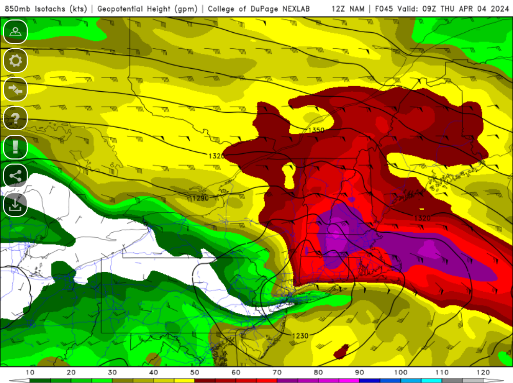
-
Significant Miller B Nor'easter watch, Apr 3rd-4th
weatherwiz replied to Typhoon Tip's topic in New England
That is one wonky thermal profile from like 800mb to 660mb or so. Looks like the NAM is trying to dynamically cool the column though on the 12z run around 42hr? -
Significant Miller B Nor'easter watch, Apr 3rd-4th
weatherwiz replied to Typhoon Tip's topic in New England
Fair -
Significant Miller B Nor'easter watch, Apr 3rd-4th
weatherwiz replied to Typhoon Tip's topic in New England
Because it's not the final solution. Certainly it doesn't bode well for borderline areas but subtle changes (in either direction) could be huge. -
Significant Miller B Nor'easter watch, Apr 3rd-4th
weatherwiz replied to Typhoon Tip's topic in New England
gotcha...should have been more clear. Meant it could be good for those riding the line as it at least keeps them in the game, it doesn't completely end hope (accounting for the possibility of more favorable ticks). -
Significant Miller B Nor'easter watch, Apr 3rd-4th
weatherwiz replied to Typhoon Tip's topic in New England
Well I guess it depends on perspective/expectations Someone somewhere is going to get whacked pretty good, unfortunately it's probably a small amount of people and a very small percent of the forum so I can understand the excitement may not be high. But at least from a meteorological perspective, this is going to be a blast to watch unfold. Storms like this though are a phenomenal learning tool. I wish in school there was a class or course (maybe there is in grad school) then was dedicated to studying historical storms. Just watching how everything evolves, interacts, and how all the processes involved lead to the evolution...anyone interested in forecasting could substantially boost their knowledge from these systems. -
Significant Miller B Nor'easter watch, Apr 3rd-4th
weatherwiz replied to Typhoon Tip's topic in New England
The NAM may be the way to go with this. It's doing a damn good job I think with the handling of the convection and evolution of the convection across the Ohio Valley. The NAM is quite scary today with the extent of the potential for severe weather and strong tornadoes. If the convection today becomes as robust as the NAM indicates that is good news for the interior and maybe for areas that are borderline currently. -
Significant Miller B Nor'easter watch, Apr 3rd-4th
weatherwiz replied to Typhoon Tip's topic in New England
yeah right -
Significant Miller B Nor'easter watch, Apr 3rd-4th
weatherwiz replied to Typhoon Tip's topic in New England
The NAM has trended significantly robust with the convective tomorrow. Going to be interesting to see what impact that has, does it rob moisture? Does it influence main low/secondary development? This is going to be a heck of an evolution to watch -
30 days Crazy how we're within a month until severe weather season and in 2 weeks the end of the GFS run will peak into May. IT'S COMING!!!
-
Significant Miller B Nor'easter watch, Apr 3rd-4th
weatherwiz replied to Typhoon Tip's topic in New England
The increase in severe weather potential and quite a bit northward shift in severe weather potential for tomorrow is wrecking some havoc. This could be a sign for a stronger primary into western Michigan at least as that would favor the warm front lifting this far north to warrant these severe probs. It will be fun later today, tonight, and tomorrow to watch in real time how the convection is influencing the upper levels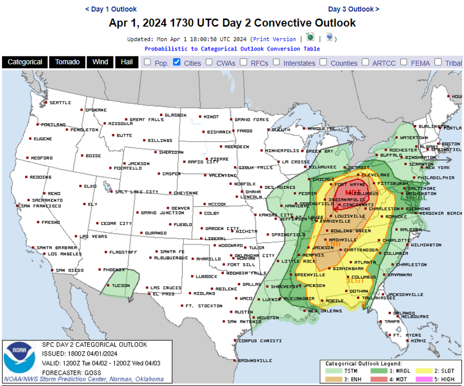
-
Significant Miller B Nor'easter watch, Apr 3rd-4th
weatherwiz replied to Typhoon Tip's topic in New England
I hardly ever look at the Canadian but this would be pretty sweet if that verified. That would be a nuking for some -
Significant Miller B Nor'easter watch, Apr 3rd-4th
weatherwiz replied to Typhoon Tip's topic in New England
There is a big of divergence between the models with this convection in the Ohio Valley. The NAM/GFS shifted north with where the bulk of the convection occurs while the HRRR is further south. This is why I think its important to closely assess where the warm front ends up today because that's where the convection will be focused. South of the warm front there may be capping issues. The NAM warm tongue would make sense if the convective solution pans out as advertised. There isn't a whole lot going on right now which could help with a farther north warm front into the Ohio Valley. -
Significant Miller B Nor'easter watch, Apr 3rd-4th
weatherwiz replied to Typhoon Tip's topic in New England
Thinking the GFS is going to be damn close to a NAM like evolution with strong primary into the Great Lakes and rapid H7 development/strengthening well west. -
Significant Miller B Nor'easter watch, Apr 3rd-4th
weatherwiz replied to Typhoon Tip's topic in New England
I would think we will have an idea of how valid the NAM will be later this afternoon or early this evening. -
Significant Miller B Nor'easter watch, Apr 3rd-4th
weatherwiz replied to Typhoon Tip's topic in New England
The NAM essentially looks like WAA precip Tuesday night/Wednesday and then precipitation quickly shuts off due to occlusion and then dry slot as H7 develops rapidly to our west. -
Significant Miller B Nor'easter watch, Apr 3rd-4th
weatherwiz replied to Typhoon Tip's topic in New England
The NAM is quite unstable in the mid-levels. Some of the most robust elevated instability I recall seeing around these parts with wintry precipitation potential. Reminds me a bit of some of those setups you see in the Great Plains where they get thunder sleet/freezing rain. -
Significant Miller B Nor'easter watch, Apr 3rd-4th
weatherwiz replied to Typhoon Tip's topic in New England
I still say we won't have a better idea of what to expect until we see how this system evolves moving through the Great Lakes today/tomorrow. How far north the warm front really gets will significantly influence convective evolution and the entire system in general. -
Significant Miller B Nor'easter watch, Apr 3rd-4th
weatherwiz replied to Typhoon Tip's topic in New England
It's just all about expectations. Of course though since everyone loves to just stroll right to the snowfall maps expectations are already lost but if you live in northern New England and/or have elevation well, climatologically you stand the best chance for some significant snowfall accumulations. We know this is going to be an anomalous evolution for this time of year and with that we should anticipate or expect there will be at least some sort of anomalous outcome. But what does that mean, well that's what we figure out over these next few days. I mean me in Springfield, it would be foolish to expect or anticipate 12'' of snow, but is it plausible to think I have a shot for say 2-4'' or 4-6'', absolutely and that's the anomalous aspect. I think mostly everyone will see frozen precipitation (except maybe immediate coastal Plain) but it's just a matter of how impactful. -
Significant Miller B Nor'easter watch, Apr 3rd-4th
weatherwiz replied to Typhoon Tip's topic in New England
I don't think we are going to have a great idea on how this will unfold until probably Tuesday evening. With multiple rounds of convection these next few days within the Missouri Valley/Ohio Valley that is surely going to greatly impact many of the key features, including the primary. With the degree of convection which seems likely along the warm front these next few days (including today) this may help shunt the warm front south a bit. It is also possible the primary low ends up being farther south and not thrown into Michigan like some guidance is showing. I think the GFS may be too far north partly because it seems to be somewhat too aggressive with how far north into the mid country the warm front lifts and ultimately it is pegging a northerly displaced MCS and subsequently, farther north with the primary. -
Significant Miller B Nor'easter watch, Apr 3rd-4th
weatherwiz replied to Typhoon Tip's topic in New England
As a Bruins fan I don't want to hear the word overtime -
Significant Miller B Nor'easter watch, Apr 3rd-4th
weatherwiz replied to Typhoon Tip's topic in New England
ahhh good call. I wanted to mention the Whites in there as well. -
Significant Miller B Nor'easter watch, Apr 3rd-4th
weatherwiz replied to Typhoon Tip's topic in New England
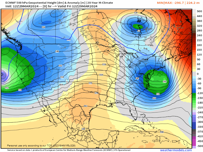
I am just in awe of the whole 500mb evolution. But while the 500 evolution is a beauty, how the surface evolves is going to be a giant PITA to figure out I think. With how things continue to look though I would not be surprised to see the highest totals in the 3 foot range and this would be achieved in favored upslope areas along the Greens and Berks. -
Significant Miller B Nor'easter watch, Apr 3rd-4th
weatherwiz replied to Typhoon Tip's topic in New England
yeah they may certainly help propel us to some more consistent warmth...at least for a time anyways. I'm sure we're still going to have to deal with some crappy periods. -
Significant Miller B Nor'easter watch, Apr 3rd-4th
weatherwiz replied to Typhoon Tip's topic in New England
That is a pretty damn near textbook evolution of the 500mb pattern and how H5 closes off and where it tracks. What may bode well too is there isn't a cluster cluck of shortwave mess. There's plenty of shortwave energy around but only a few distinct major pieces. If you're outside of the far interior and don't have elevation, dynamics are going to be critical but there is plenty of cold air available not far away.