weatherwiz
-
Posts
79,820 -
Joined
-
Last visited
Content Type
Profiles
Blogs
Forums
American Weather
Media Demo
Store
Gallery
Everything posted by weatherwiz
-

May 2024 Discussion - Welcome to Severe Season!!!!
weatherwiz replied to weatherwiz's topic in New England
nahhh I don't think we are going to see much of anything. Maybe a few cells but it is super dry aloft and looks like a strong mlvl cap and perhaps some subsidence behind AM activity. Anything that does pop is going to really struggle IMO -
May 2024 Discussion - Welcome to Severe Season!!!!
weatherwiz replied to weatherwiz's topic in New England
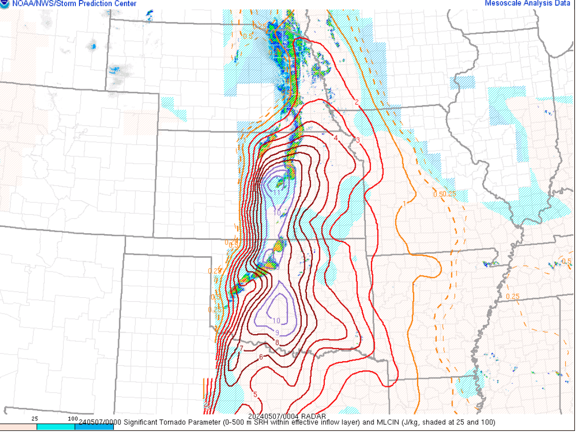
I thought maybe the SPC did go a bit much with this. The high Risk, the PDS Watch, some of the wording was pretty intense as well. It seems like there has become more of a focus on parameters than the overall picture. I think even within the SPC discussion, there was some questioning about storm mode and a few other flags but went on the aggressive side given how models were indicating Significant Tornado Parameter Values of 10+...which is absolutely insane but we have to remember those do not mean anything if you don't have the right storms to utilize them. It seems like there has been a large movement within the forecasting industry to focus on parameters, AI products, analogs and reverting away from using what is most valuable, understanding the setup on hand and incorporating historical knowledge. -
May 2024 Discussion - Welcome to Severe Season!!!!
weatherwiz replied to weatherwiz's topic in New England
Communicating these types of events I'm sure is not easy, especially because you're dealing with a weather phenomena which is only impacting a small fraction of people compared to the overall geographic size where the potential exists. But the way I see it is, if you continue to use extreme wording time and time again, eventually those words lose value. A professor I had in school (who was in broadcasting) always use to say, when you're communicating weather (or anything in life really), choose your words carefully because how you define your words is how the audience is going to perceive and understand them. For example, if you keep saying "this weather is beautiful" obviously everyone is going to have their own definition of it, but what does it really mean. If you're using it for when it's 45F and sunny, 58F and sunny, 73F and sunny...do you really want to use beautiful for when it is 45F and sunny? Wouldn't you want to save that for when it truly is? Otherwise, the meaning of the word becomes diminished. Back to the severe weather...if wording such as "potential for strong/violent tornadoes" gets used over and over, eventually people may just let their guard down because how many times can you hear the same thing and not see anything happen (and by not see anything happen I don't mean a person's backyard, I mean for the picture as a whole). Like with our area, we get so many low potential setups (low cape/high shear) that maybe out of every 20, 1 or 2 produce tornadoes. But if you keep saying, "there is a chance for a tornado" every time...and nothing happens...well that one day when it actually may/does people may have their guard down. Maybe this would be on the people for letting their guard down but a large part is how things are communicated. Social media I think has made this much worse though because now you just have everyone posting STP maps, UH maps, etc. -
May 2024 Discussion - Welcome to Severe Season!!!!
weatherwiz replied to weatherwiz's topic in New England
I don't think we see much develop tomorrow. It is very dry above 900mb. -
May 2024 Discussion - Welcome to Severe Season!!!!
weatherwiz replied to weatherwiz's topic in New England
IDK if it's just me but it seems like there has been a significant upward trend in I don't want to say hyping events, but using extreme wording. Now I get that many of these setups have had ingredients worthy of such potential but as you know there is much more to it than that. The overall environment yesterday was quite concerning but it looked as if the storm mode was going to be very messy. I wonder if alot of this is being driven by these AI driven products. There is that Nadocast thing that is always going around I think something else too. -
May 2024 Discussion - Welcome to Severe Season!!!!
weatherwiz replied to weatherwiz's topic in New England
Looks like the win probability for Bos/Fla during the 3rd last night -
May 2024 Discussion - Welcome to Severe Season!!!!
weatherwiz replied to weatherwiz's topic in New England
Thought the same to myself when heading out the door earlier. Nearly perfect. Had a bit of a chill in the car so had some heat going, but also to clear the windshield of dew. Absolutely zero complaints about this morning. For those not blessed with this...sorry I guess. -
May 2024 Discussion - Welcome to Severe Season!!!!
weatherwiz replied to weatherwiz's topic in New England
Tornado Emergency in Oklahoma...oh my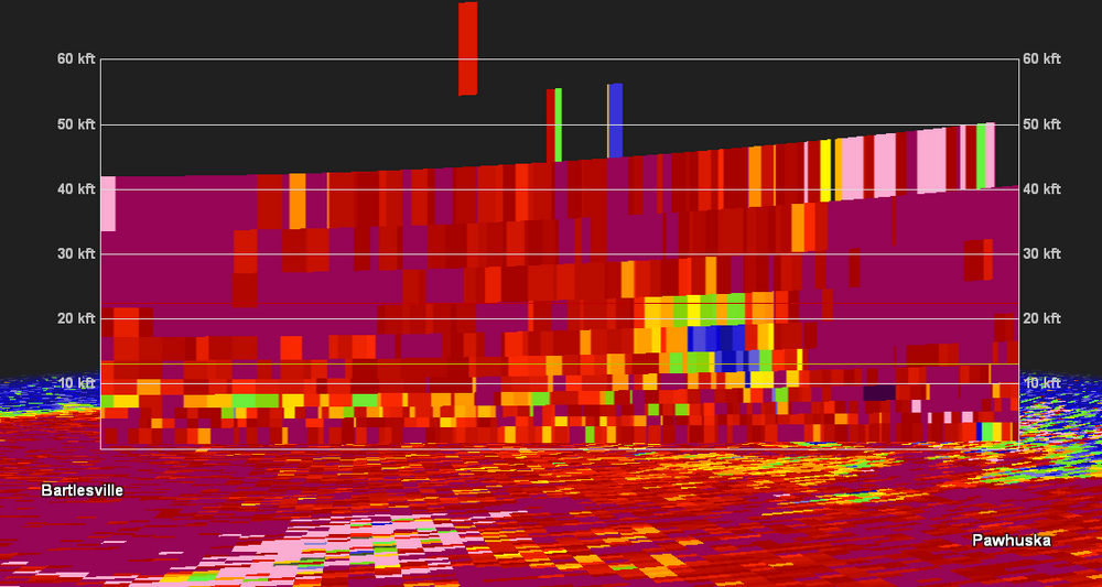
-
May 2024 Discussion - Welcome to Severe Season!!!!
weatherwiz replied to weatherwiz's topic in New England
congrats, welcome to the club -
May 2024 Discussion - Welcome to Severe Season!!!!
weatherwiz replied to weatherwiz's topic in New England
Was scared you were going to post Ryan H*** -
May 2024 Discussion - Welcome to Severe Season!!!!
weatherwiz replied to weatherwiz's topic in New England
Just brutal man...really -
May 2024 Discussion - Welcome to Severe Season!!!!
weatherwiz replied to weatherwiz's topic in New England
oof
-
May 2024 Discussion - Welcome to Severe Season!!!!
weatherwiz replied to weatherwiz's topic in New England
A good way to differentiate spring from autumn
-
May 2024 Discussion - Welcome to Severe Season!!!!
weatherwiz replied to weatherwiz's topic in New England
Wow...I think this is the first time I've ever seen the discussion from this event! -
May 2024 Discussion - Welcome to Severe Season!!!!
weatherwiz replied to weatherwiz's topic in New England
5/31/98 featured a high risk but that was mostly NY/PA although I think the high risk may have tapped into Berkshire County/Litchfield County. 6/1/2011 I believe was Slight. I believe probs were 5% tor and 30% wind. I would guess that probably would have been a moderate. Although with the number of tornadoes which occurred that day at least, if that degree of tornadoes was anticipated it may have elicited a 15% hatched tornado which would qualify for high risk. -
May 2024 Discussion - Welcome to Severe Season!!!!
weatherwiz replied to weatherwiz's topic in New England
Funny you post this...someone sent me this video earlier. That is insane. Building is totally gone in like 3 seconds. -
May 2024 Discussion - Welcome to Severe Season!!!!
weatherwiz replied to weatherwiz's topic in New England
I don't think so. -
May 2024 Discussion - Welcome to Severe Season!!!!
weatherwiz replied to weatherwiz's topic in New England
I wonder if we'll ever see a high risk any further east than what we saw 5/31/98. The only way it ever happens if there was a legit signal for a derecho to rip across NY/PA and SNE (or NY across NNE). We would never see a high risk for tornado probs, one reason being the spatial size of our geography is just too small. I wonder what the outlook was for 7/15/95. -
May 2024 Discussion - Welcome to Severe Season!!!!
weatherwiz replied to weatherwiz's topic in New England
I would think we do break out into mostly sunny skies after the morning round of rain/thunder. Perhaps our best chance for anything is with the morning stuff which will be elevated. Looks like we remain on the stable side though in the afternoon with an onshore flow. HV could be a decent spot should convection re-develop. -
May 2024 Discussion - Welcome to Severe Season!!!!
weatherwiz replied to weatherwiz's topic in New England
Wow that is cheap! -
May 2024 Discussion - Welcome to Severe Season!!!!
weatherwiz replied to weatherwiz's topic in New England
I'm a bit bummed actually. When I was looking at vort, wind, and lapse rates then got to QPF I was shocked the NAM wasn't spitting much of anything out during the afternoon. Initial thoughts were maybe too much cloud junk or maybe shortwave subsidence. But getting into soundings...bone dry within the mid-levels and even into the lower-levels. -
May 2024 Discussion - Welcome to Severe Season!!!!
weatherwiz replied to weatherwiz's topic in New England
blahhhh that's some nice shortwave forcing Wednesday with steep lapse rates but its awfully dry aloft. -
May 2024 Discussion - Welcome to Severe Season!!!!
weatherwiz replied to weatherwiz's topic in New England
Going to be something watching how everything unfolds there later. Seems to be like the storm mode could be a bit messy. Overall though its a pretty scary setup as the greatest concern for tornadoes is evening/overnight. With the greatest concentration of forcing north of Oklahoma with a strengthening mlvl wind max across Oklahoma overnight, there could be enough for discrete supercells within Oklahoma which would not be good. -
May 2024 Discussion - Welcome to Severe Season!!!!
weatherwiz replied to weatherwiz's topic in New England
oh wow...yeah I see the MCD -
May 2024 Discussion - Welcome to Severe Season!!!!
weatherwiz replied to weatherwiz's topic in New England
Marginal risk tickling my fanny for Wednesday!