weatherwiz
-
Posts
79,820 -
Joined
-
Last visited
Content Type
Profiles
Blogs
Forums
American Weather
Media Demo
Store
Gallery
Everything posted by weatherwiz
-

May 2024 Discussion - Welcome to Severe Season!!!!
weatherwiz replied to weatherwiz's topic in New England
awww damn...I would have enjoyed it much better had I known. -
May 2024 Discussion - Welcome to Severe Season!!!!
weatherwiz replied to weatherwiz's topic in New England
It's possible I saw something. There was some "shadowing" towards the bottom right of the Sun. Not sure what it would look like viewing through eclipse glasses since I've never done it. Clouds totally rolled in now so no shot to look again. -
May 2024 Discussion - Welcome to Severe Season!!!!
weatherwiz replied to weatherwiz's topic in New England
I don't see any sunspots on the Sun. I think its a hoax -
@Ginx snewx Do you have any recommendations on dog exercises to strengthen their lower back? Back in December, I was outside playing with the dog and he was chasing the ball. All of a sudden he let out a series of yelps and tumbled over. My initial thought was he re-injured his leg because he was favoring his leg. Before my gf and I met, he had injured himself jumping the fence and a few months after dating he had to get ACL surgery I think on his back right leg and this time it was his back left leg. We were nervous because they told us there is a good chance he will injure the other one at some point. Anyways, we got him into an emergency vet and after doing some tests and checking him out, they realized he may have actually done something to his lower back (when they did some light pressing on his spine he reacted towards his lower spine and when they did a paw flip thing, he didn't really react when they put his back left paw backwards...it just kind of flopped). They told us they believe he could have had a minor stroke in his back but didn't think there was anything serious. I was nervous about something more serious so shelled out $3,500 for an MRI, which thankfully showed nothing serious. They expected him to fully recover. Anyways, probably within a few weeks we were back to playing. I think it was last Friday or Friday before, he seemed to be in some pain which was the first time since the injury. You can tell though its still on the weak side. Do you know of anything we can try to maybe strengthen the lower back?
-
May 2024 Discussion - Welcome to Severe Season!!!!
weatherwiz replied to weatherwiz's topic in New England
damn it I couldn't see anything -
May 2024 Discussion - Welcome to Severe Season!!!!
weatherwiz replied to weatherwiz's topic in New England
Really? I might go do that right now -
May 2024 Discussion - Welcome to Severe Season!!!!
weatherwiz replied to weatherwiz's topic in New England
Was not expecting this much Sun. Pretty nice out right now anyways. -
May 2024 Discussion - Welcome to Severe Season!!!!
weatherwiz replied to weatherwiz's topic in New England
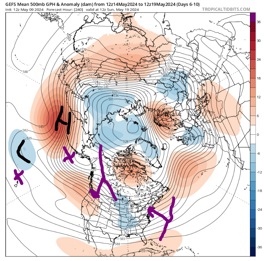
Funny you post this because I did dap into the charts to see what the forecasts were for the NAO/PNA. I thought that was noteworthy, but like you said ens means were not as representative as what you would expect to see in terms of pattern across the country. One thing came to mind: As you know, the placement and structure of the anomaly centers are more important than just the chart. Here is the 12z GEFS 6-10 day mean. Excuse my terrible drawing skills but I'll try to explain what I'm getting at: 1. I wonder if the chart is being skewed by the highly anomalous High pressure center northwest of the Aleutians and the trough jut north of Hawaii. I believe this is the far western edge of the PNA domain but this could be providing enough weight to make the chart "quite negative". 2. Getting into the placement of the anomaly centers, you can see we might not be far off from significantly warmer temperatures. If the high center was more so over the Aleutians or maybe just south and the trough centered over Hawaii, would that maybe act to flatten the ridge there across the PAC NW and open the door to connect the trough over the central states with the western Arctic domain or at least tug the trough west? With the mean trough in the West as opposed to the central we may be able connect the ridge off the coast and bring that west
-
May 2024 Discussion - Welcome to Severe Season!!!!
weatherwiz replied to weatherwiz's topic in New England
That's what I'm thinking. We're going to get our nice days, and some of us will get more than others and that's just the nature of our region's climo but I think we have at least another few weeks before we can say that type of weather becomes more consistent. I would not be surprised if the switch flipped in the flash of an eye. I mean that's what kinda of seems to happen here anyways but we'll probably go from 50's and 60's (with our days of 70's) right to 80's and torch spots hitting 90 with humidity. -
May 2024 Discussion - Welcome to Severe Season!!!!
weatherwiz replied to weatherwiz's topic in New England
perhaps end of May sure...but I was focused on the next few weeks really. -
May 2024 Discussion - Welcome to Severe Season!!!!
weatherwiz replied to weatherwiz's topic in New England
As much as I am dying to get into a weather pattern where we get consistent warmth I think we have quite a bit to go until we get there. We've been in such a shit pattern and its just slowly eroding away, however, its just rotting so we'll left with its dead corpse. There is nothing really driving a change. -
May 2024 Discussion - Welcome to Severe Season!!!!
weatherwiz replied to weatherwiz's topic in New England
Yup...we had a little back and forth going about the warm front and how far into the region it would push. I wish I spent more time looking into it but had alot of other stuff going on. Everything looked pretty impressive but I just harped too much on drier air aloft. But looking back I should have known that would be a non issue given the strength of the forcing approaching and increasing 850 theta e I think it was. it's not too often either we get supercellular storms riding along warm front boundaries in these parts. Even with some of the stableness around, I believe much of the storm inflow was coming from within the stronger warm sector. -
May 2024 Discussion - Welcome to Severe Season!!!!
weatherwiz replied to weatherwiz's topic in New England
Let's hope we can keep the EML's coming. -
May 2024 Discussion - Welcome to Severe Season!!!!
weatherwiz replied to weatherwiz's topic in New England
The only flashes I've seen are the flashes of brilliance from Swayman. Not sure why I haven't seen any flashes...but there is a ton of thunder. -
May 2024 Discussion - Welcome to Severe Season!!!!
weatherwiz replied to weatherwiz's topic in New England
3rd round of thunder today! -
May 2024 Discussion - Welcome to Severe Season!!!!
weatherwiz replied to weatherwiz's topic in New England
Another day another tornado emergency. Nasty tornado well south of Nashville. Debris up to looks like 10-15K -
May 2024 Discussion - Welcome to Severe Season!!!!
weatherwiz replied to weatherwiz's topic in New England
Great call today! I poo-pooed and got poo-pooed on -
May 2024 Discussion - Welcome to Severe Season!!!!
weatherwiz replied to weatherwiz's topic in New England
Another thunderstorm passing by. -
May 2024 Discussion - Welcome to Severe Season!!!!
weatherwiz replied to weatherwiz's topic in New England
I keep going back and forth at it. My initial reaction was straight line too because there was nothing glaring showing rotation (you had the green/red next to each other but they were moving conjointly) but it looked like there was a brief scan with a small area of rotation and a drop in CC. But it's probably nothing. -
May 2024 Discussion - Welcome to Severe Season!!!!
weatherwiz replied to weatherwiz's topic in New England
might have been a very brief TDS -
May 2024 Discussion - Welcome to Severe Season!!!!
weatherwiz replied to weatherwiz's topic in New England
yup same here. It was super weird. Per radar, I was under red echos...like smack in the middle and zero was going on at the ground. Was probably under those echos for a solid 5 min before anything happened lol -
May 2024 Discussion - Welcome to Severe Season!!!!
weatherwiz replied to weatherwiz's topic in New England
nahhh my girlfriend setup spider traps down there -
May 2024 Discussion - Welcome to Severe Season!!!!
weatherwiz replied to weatherwiz's topic in New England
ughhh lasted for 2 seconds -
May 2024 Discussion - Welcome to Severe Season!!!!
weatherwiz replied to weatherwiz's topic in New England
PEA SIZED HAIL!!!! -
May 2024 Discussion - Welcome to Severe Season!!!!
weatherwiz replied to weatherwiz's topic in New England
Saw a bright flash of lightning and right away it started to rain