weatherwiz
-
Posts
79,820 -
Joined
-
Last visited
Content Type
Profiles
Blogs
Forums
American Weather
Media Demo
Store
Gallery
Everything posted by weatherwiz
-
There's one in Miilford (Silver Sands or something) which isn't a terrible beach. It gets super crowded. The water can be ehhh but during the low tide cycle there is a small little "island" you can walk out too. Just have to be aware though because once high tide starts kicking back in, if you're not a strong swimmer...better start hauling.
-
usually starts running about 6-7 minutes before the hour. We're onto 13z run now
-
There is a private beach in Clinton, CT (its free for Clinton residents but non-residents its like $50...but that was several years ago) that is pretty decent. Very quiet and relaxing, they have a few shops too open during the summer.
-
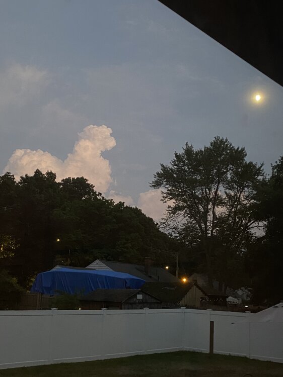
This is cool
-
Crazy cool looking sky. Reminds me of Independence Day when the flying saucer comes over DC and the white beam comes out and lights everything up
-
Just got backed to Springfield. Too late to do any chasing, was hoping more would develop on the southern flank.
-
Can’t always get what you want
-
yeah not good at all. If you still plan on going make sure you have cover quickly available. Have to worry about any CGs out ahead of the line.
-
That is a monster bow taking shape.
-
strengthening wind field associated with the approaching shortwave/mcv. The sfc wind direction may limit the extent farther east, but if winds start backing with time there may be enhanced potential in the valley
-
agreed, this is setting up to be a biggie. Despite the linear mode, I think tornado potential is being downplayed somewhat.
-
New SVR much of VT into central MA
-
Have to see how organized the cold pools can become. But I suspect we should see rapid weakening towards the coast there.
-
Same thing that happened back in December, except this time was more severe. We were outside for 2 seconds last Wednesday about to play and he gets all excited and jumps on his hind legs and twists. When he did that he screamed in pain...absolutely screamed and had zero movement of his back legs. He scooted around the yard on his butt. He kept trying to stand up but kept flopping over. I was home alone and my girlfriend was over an hour away. So a friend came to help me carry him into the car and I brought him to the emergency vet. MRI revealed he had a second stroke in his spine (happened back in December), except this impacted both sides and why he lost all feeling and control of his back legs. They say he will make a full recovery, however, they aren't sure what caused it the first time or this time. There was nothing evident in his blood test, however, they did another blood test Friday but have not gotten the results back (so guessing they are doing something more substantial. He's slowly been getting some feeling in his back legs, but still no movement of the legs.
-
yup...and even more north of me. Have to drive to Middletown, CT later to visit the dog in the hospital and give it another go of practice with performing bladder expressions.
-
Already enjoying the outdoors. I do have an exquisite weekend dew story. Thursday I went to Costco's (which was a total disaster. Had $400 worth of stuff and I didn't realize (or forgot) they ONLY ACCEPT VISTA). Anyways, I wore jeans, it was another soaking experience. I went to a different Costco's Friday (with my Vista) and it was another beautiful, soaking experience. Saturday was my gf 30th birthday and we had a party. Sat outside all day, just drenched in sweat. Clothes and everything soaked. Sunday was my nieces gender reveal and it was another soaking, dripping experience. There is nothing better than being totally wet in the summer then taking a nice warm shower and feeling refreshed. But the feeling of sensation when it is above 90, dewpoints above 70, and the Sun beating down on you is unmatched pleasure in the romantic sense and the tingles generated by each drop of sweat as it slowly trickles down every ounce of your body is indescribable. Thinking of doing an OnlyFans, dewpoint sensations and romantic pleasure, next year if anyone wants to subscribe.
-
12z NAM is violence up north today. Phil going to be busy later on
-
I want some 70 dews into late September/October when we get out Fall shortwaves.
-
until August 16
-
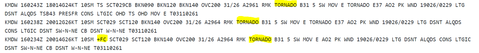
Is this the second time within a year MDW reported a tornado?

-
Should be convectively active too.
-
I was 6 at the time. I remember that morning, though it was some years before I could correlate it with the label of the event. I woke up around 6 or 6:30 that morning and wasn't feeling well so I went out to the living room to turn on The Weather Channel. I had the station on for I have no clue how long and there was no weather. My mom then woke up and I asked her...I guess it turned out they had changed the TV station line up that morning or maybe the night before. Anyways, as soon as she finds TWC, first thing I see is them showing the radar and this massive line moving across western Mass. I am also presenting on this at the TriState Weather Conference at WestConn in September!
-
That’s why I didn’t go outside to take pics of the storm to my northwest. RadarScope was throwing out CGs outside of the storm.
-
Not sure if there is some sort of convective feedback going on wrt the shortwave but the 18z NAM would be quite interesting tomorrow evening
-
Areas with more rainfall may certainly see a local boost in the dewpoints. This may become more noticeable during the peak heating cycle when mixing is strongest and dewpoints may mix. But if you have that extra available moisture source, that can help keeps dews up...though I would suspect probably not a heck of a lot more. Lots of other influences as well to consider, terrain, wind direction, theta-e ridging/pooling, if present, etc.