

weatherwiz
-
Posts
80,900 -
Joined
-
Last visited
Content Type
Profiles
Blogs
Forums
American Weather
Media Demo
Store
Gallery
Everything posted by weatherwiz
-
ahh yes...yeah the new site is much better. Wish it was available mobile (unless it is now)
-
Do you use it on pc or mobile? cod is definitely not user friendly mobile
-
Really? I use it all the time and haven't had any issues...outside of some instances where the NAM gets "stuck"
-
tickle me elmo
-
I do think region wide we'll be upper 80's to lower 90's and maybe even closer to 95 in the torch spots, but the most interesting aspect about the pattern is we could end up in a favorable position with respect to the ridge axis for EML advection and MCS propagation from the Great Lakes/southeast Canada!
-
Thank God. Its been a while day since we've had rain. Another day without rain and we'd be crying drought again
-
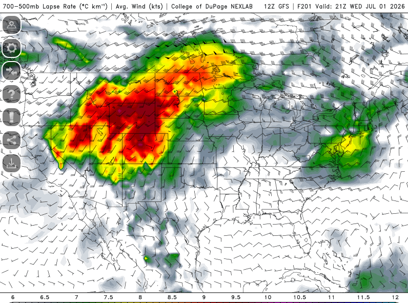
Pretty interesting/weird how the GFS blossoms QPF in the Tennessee Valley region mid-week directly under the heart of the ridge
-
speaking of GFS...lets hope it verifies next week. We ride the MCS train
-
Something to watch for sure. This setup, if verified, could argue for some flooding potential across southern CT. southern CT right on the edge of the stronger llvl jet and more robust elevated CAPE with the boundary just south. Perfect scenario for training
-
Stalls that cold front just to our south tomorrow evening and then either slowly lifts it back north as a warm front or just remains a stationary front with a wave developing along it. GFS has it too. Wonder if alot of this depends on MCS developing and evolution tomorrow within the midwest
-
Should see a few strong storms tomorrow, particularly north of the Pike. Dries out quite a bit aloft which tapers down potential aerial coverage. Too bad because shear is pretty solid for late June
-
Is it even possible to mix to 700mb around these parts?
-
Tuesday (with a high of 88) is described as "nice" while Thursday (with a high of 86) is described as hot (granted it says humid) but still lol.
-
hmmm well it is Colorado, maybe was trying to put an order in for edibles
-
TBH, I hope it does setup right over the mid-South and we end up on the eastern periphery. You could bet we would get some EML plumes advecting in at times along with some MCS opportunities...but yeah that all may get shunted towards the mid-Atlantic
-
The heat and humidity is coming...buckle up, settle in, and enjoy.
-
That was definitely cheesy...and the trailing car getting sucked away...reminded me of when you would get sucked up by that sun in Super Mario 3
-
Night of the Twisters was awesome, read the book too. But, wasn't this based on a "true" event? And I say "true" because the specifics/details weren't exactly based on reality but the background of the event was
-
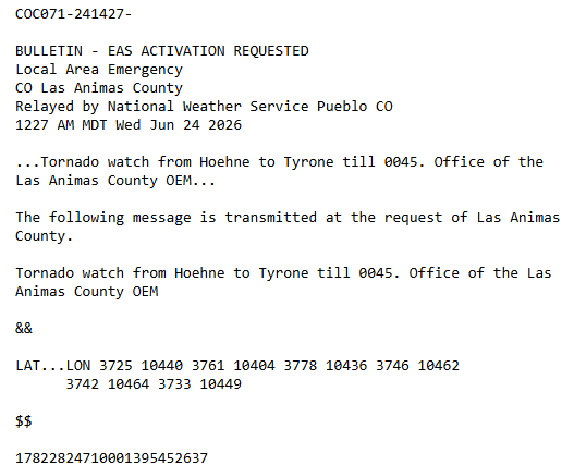
I didn't even notice that Sounds like how watches work in Canada
-
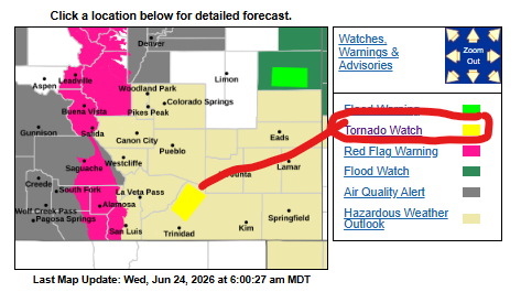
wth is this. @OceanStWx
-
Lets rip in an MCS from Canada
-
Given this (granted its early) I don't think tropical is anything we'll be tracking. Unless you want to count any remnant Gulf systems being absorbed in troughs come Fall and moving up to our west
-
Probably be some decent rains SOP tomorrow...might be a couple different waves of it
-
May get some loud overnight elevated convection tonight across SE CT into MA and far SE MA
-
Today worked out pretty well. Performed as it should have


