MGorse
-
Posts
2,282 -
Joined
Content Type
Profiles
Blogs
Forums
American Weather
Media Demo
Store
Gallery
Everything posted by MGorse
-

Saturday night/Sunday 12/13-12/14 Jawn
MGorse replied to Ralph Wiggum's topic in Philadelphia Region
Yeah that report and probably a few others should have been removed from the final PNS. Just remember though, reports in PNSs and LSRs are all considered preliminary (not official). -
Saturday night/Sunday 12/13-12/14 Jawn
MGorse replied to Ralph Wiggum's topic in Philadelphia Region
Parts of Philly did.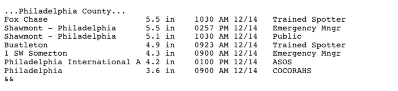
-
Saturday night/Sunday 12/13-12/14 Jawn
MGorse replied to Ralph Wiggum's topic in Philadelphia Region
Total at PHL is 4.2 inches. Probably a little low. -
Saturday night/Sunday 12/13-12/14 Jawn
MGorse replied to Ralph Wiggum's topic in Philadelphia Region
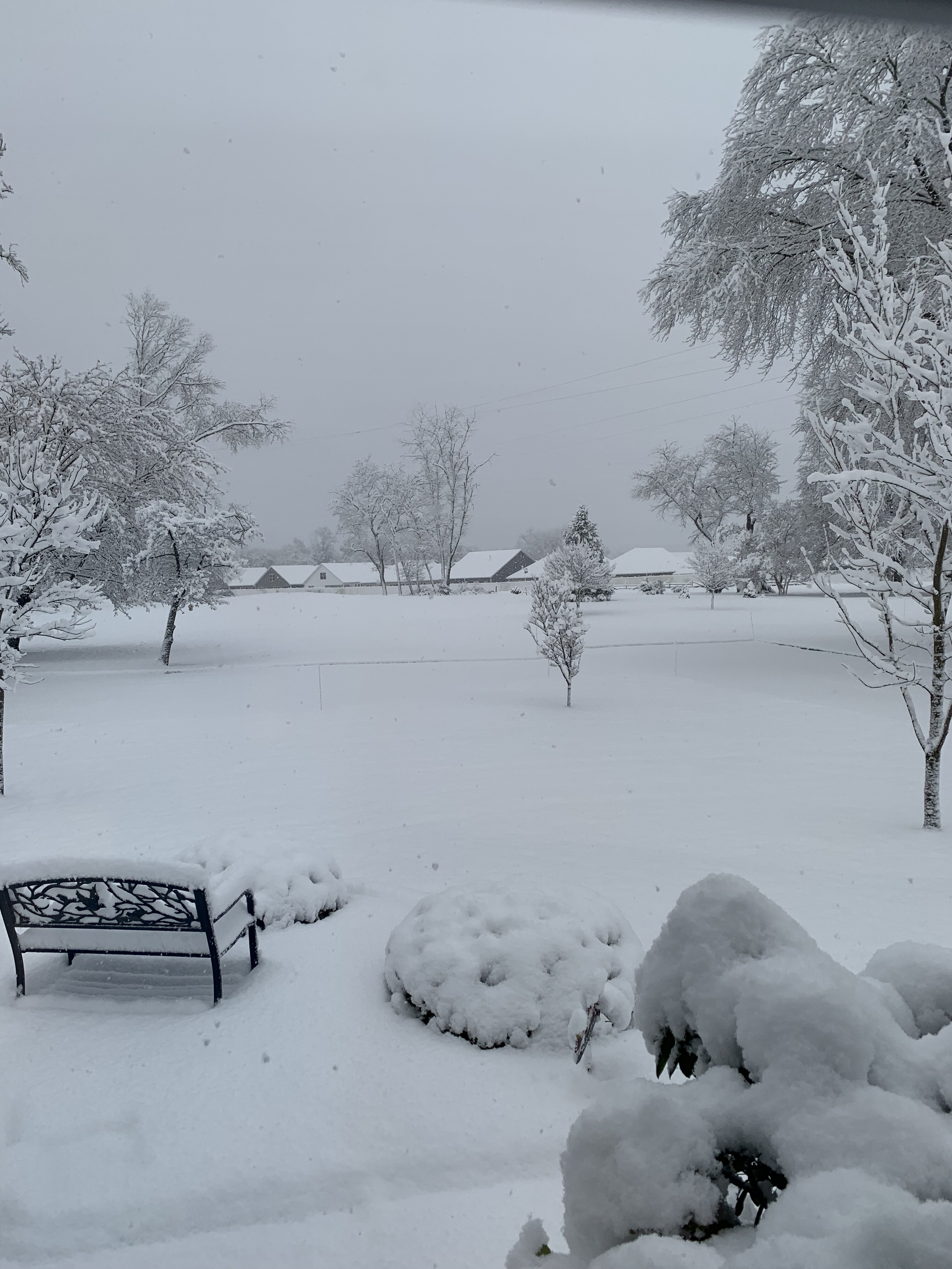
My backyard early this morning.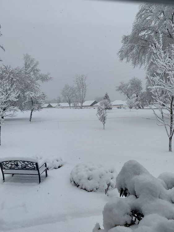
-
Saturday night/Sunday 12/13-12/14 Jawn
MGorse replied to Ralph Wiggum's topic in Philadelphia Region
A total of 6 inches of snow at my place. The bottom layer on my driveway, sidewalks and deck was like concrete. -
Saturday night/Sunday 12/13-12/14 Jawn
MGorse replied to Ralph Wiggum's topic in Philadelphia Region
Given some of the model guidance 700-850 mb FGEN, there may be multiple heavier narrow bands embedded within the widespread snow shield. These could be somewhat transient though. -
Saturday night/Sunday 12/13-12/14 Jawn
MGorse replied to Ralph Wiggum's topic in Philadelphia Region
A few sprinkles here a little while ago. -
Saturday night/Sunday 12/13-12/14 Jawn
MGorse replied to Ralph Wiggum's topic in Philadelphia Region
That wording is tied to the hazard. In this case, a warning. -
Saturday night/Sunday 12/13-12/14 Jawn
MGorse replied to Ralph Wiggum's topic in Philadelphia Region
Yup, although it is possible it starts as a rain/snow mix here. If that does occur, hopefully it will be brief. -
Saturday night/Sunday 12/13-12/14 Jawn
MGorse replied to Ralph Wiggum's topic in Philadelphia Region
I hear there is accumulating snow on the way. -
E PA/NJ/DE Winter 2025-26 Obs/Discussion
MGorse replied to LVblizzard's topic in Philadelphia Region
Low temperature of 11F here early this morning. -
E PA/NJ/DE Winter 2025-26 Obs/Discussion
MGorse replied to LVblizzard's topic in Philadelphia Region
We are that good. -
E PA/NJ/DE Autumn 2025 Obs/Discussion
MGorse replied to PhiEaglesfan712's topic in Philadelphia Region
Mowing my lawn (mostly to pick up lots of leaves) between 3:30-4:00 PM today and a few minutes in, sleet was falling. Perhaps I should have looked at the radar first. Lol Did not have that on my bingo card today. -
E PA/NJ/DE Autumn 2025 Obs/Discussion
MGorse replied to PhiEaglesfan712's topic in Philadelphia Region
Low of 28F earlier this morning with frost. -
E PA/NJ/DE Autumn 2025 Obs/Discussion
MGorse replied to PhiEaglesfan712's topic in Philadelphia Region
Hour 354! LOL -
E PA/NJ/DE Autumn 2025 Obs/Discussion
MGorse replied to PhiEaglesfan712's topic in Philadelphia Region
33F for a low early this morning with frost. -
E PA/NJ/DE Autumn 2025 Obs/Discussion
MGorse replied to PhiEaglesfan712's topic in Philadelphia Region
After a downpour earlier this evening, total is at 1.26”. -
E PA/NJ/DE Autumn 2025 Obs/Discussion
MGorse replied to PhiEaglesfan712's topic in Philadelphia Region
Yup. Just a bit humid. -
E PA/NJ/DE Autumn 2025 Obs/Discussion
MGorse replied to PhiEaglesfan712's topic in Philadelphia Region
1.12” of rain. 66F with some sunshine. Actually humid out. -
E PA/NJ/DE Autumn 2025 Obs/Discussion
MGorse replied to PhiEaglesfan712's topic in Philadelphia Region
Based on the obs, those amounts were from 8 AM. Rain continues. -
E PA/NJ/DE Autumn 2025 Obs/Discussion
MGorse replied to PhiEaglesfan712's topic in Philadelphia Region
0.64” so far. 59F. -
E PA/NJ/DE Autumn 2025 Obs/Discussion
MGorse replied to PhiEaglesfan712's topic in Philadelphia Region
Bottomed out at 33.2F just before 6 AM. Observed some frost. -
E PA/NJ/DE Autumn 2025 Obs/Discussion
MGorse replied to PhiEaglesfan712's topic in Philadelphia Region
Hi Paul. We look at all the temperature data we have access to and based on that, the zone/county has to have half or more coverage of temperatures at or below 32F to end the growing season. The growing season is also ended if it is two weeks beyond the median first Fall freeze date and no freeze has occurred. Little plant growth can be expected beyond that date. -
E PA/NJ/DE Autumn 2025 Obs/Discussion
MGorse replied to PhiEaglesfan712's topic in Philadelphia Region
Low of 36.5F at 7:30 AM. Now up to 49F. -
E PA/NJ/DE Autumn 2025 Obs/Discussion
MGorse replied to PhiEaglesfan712's topic in Philadelphia Region
0.27” of rain last night. Definitely more than what I was expecting.