-
Posts
2,259 -
Joined
Content Type
Profiles
Blogs
Forums
American Weather
Media Demo
Store
Gallery
Everything posted by MGorse
-
E PA/NJ/DE Winter 2025-26 Obs/Discussion
MGorse replied to LVblizzard's topic in Philadelphia Region
The Global High-Resolution Atmospheric Forecasting (GRAF) model is a propriety, physics based, numerical weather prediction system developed by The Weather Company (an IBM Business) in collaboration with the National Center for Atmospheric Research (NCAR). -

E PA/NJ/DE Winter 2025-26 Obs/Discussion
MGorse replied to LVblizzard's topic in Philadelphia Region
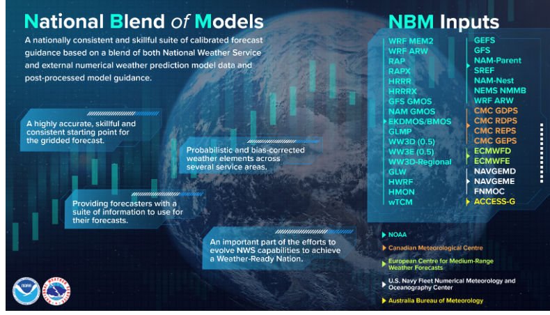
We are required to use the NBM for the official NWS forecast. Through collaboration though we can edit that if it is significant enough. It is quite the touchy new policy that many are not happy with. It basically adds more work than saving time as we were told it would. NBM has its flaws plus it always lags behind at least one model cycle. -
It can vary.
-
As of 1 PM... 7.4" at PHL. 6.6" at NWS Mount Holly
-
Changing to sleet here at NWS Mount Holly.
-
More sleet reports from central to southern DE over to southern Cape May County.
-
There is ongoing FGEN, it is just more spread out looking on the radar currently (resulting in a large area of moderate to heavy snow).
-
Yup, given the visibility reductions looks like more snow than sleet. More of a mix or changeover closer to coastal Sussex County, DE.
-
DELDOT cameras show some snow still falling south of there.
-
Or pulling your hair out trying to message this mess to the public and partners.
-
What a freaking mess! If heavier rates can hold on longer that could be enough to keep the warm layer colder and thus hang onto snow longer.
-
It is not easy reaching blizzard criteria. In this case, the GFS, NAM and NAMnest soundings in the Lehigh Valley do show some wind however it is not ideal mixing. I am not sold on actual blizzard conditions occurring.
-
Meaning not occasional gusts. I think the idea is the gusts have to be occurring often and not just here and there.
-
It is sustained or frequent gusts to 35 mph or greater.
-
It depends on whether it is planar/flat or radial ice. Forecasts are planar/flat ice accretion which is less than radial ice. For trees and power lines, it is the greater radial ice accretion that causes the problems (generally above 0.25 inches of accretion).
-
Just ice from freezing rain.
-
Looking at some of the model forecast soundings, some of the guidance is showing freezing rain or even plain rain (depending on location) however the sounding looks more like sleet. Model snowfall graphics typically include sleet as snow and sleet are counted together. The FRAM graphic above is strictly ice accretion from freezing rain. The Kuchera snowfall maps be careful with as it only uses the maximum temperature aloft to calculate snowfall. The 10:1 ratio maps also use with caution as that ratio is not usually representative during a storm as the ratios certainly change up and down as the storm evolves.
-
Looks to me more like snow pellets or sleet with that isothermal to just a tad above freezing layer aloft.
-
-
That is straight from the NBM guidance.
-
We finally switched to the new format/slides as well.
-
It is going to be a long rest of the week!
-

January 18th Back Door NW Trend Snow OBS Thread
MGorse replied to Mikeymac5306's topic in Philadelphia Region
Snow on snow for many, not bad! -

E PA/NJ/DE Winter 2025-26 Obs/Discussion
MGorse replied to LVblizzard's topic in Philadelphia Region
Impressive! -

E PA/NJ/DE Winter 2025-26 Obs/Discussion
MGorse replied to LVblizzard's topic in Philadelphia Region
A total of 1.04 inches of rain.


