MGorse
-
Posts
2,280 -
Joined
Content Type
Profiles
Blogs
Forums
American Weather
Media Demo
Store
Gallery
Everything posted by MGorse
-
Yup, nothing like seeing precipitation on the radar overhead for awhile yet you keep looking out at the porch light and see no snow.
-
PHL's dew point is at 12F as of 8 PM. Mount Pocono's dew point is sitting at 7F.
-
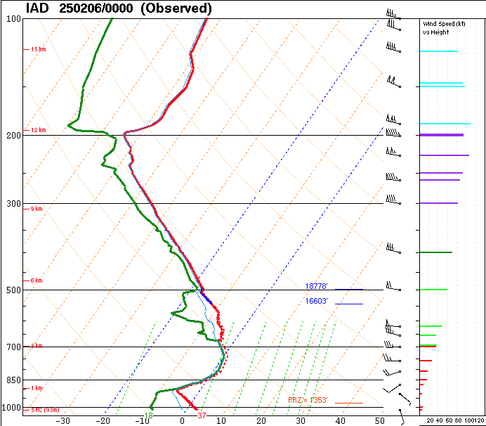
The 00z Dulles/Sterling RAOB (sounding) already shows a decent layer of above freezing air aloft. It is not above freezing by much but it is there. This likely is not as warm aloft farther northeast yet along with much drier air.
-
The dew points are certainly low. It will be interesting to see what happens overnight and early Thursday morning as the initial cooling occurs with the onset of the precipitation while the warm air advection strengthens the warm layer aloft. It will be a battle!
-
Tray tables up and fasten seatbelts.
-
All aboard the GFS train.
-
The 18z NAM has quite the 700-850 mb FGEN forcing resulting in that initial focused band of heavier snow.
-
Who or what was forecasting 50 degrees today in the Poconos?
-
0.54 inches of rain here.
-
This rain is much needed, but also great to see the layers of salt finally washed away.
-
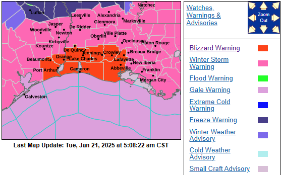
Anyone have a Blizzard Warning today for southwestern Louisiana on their bingo card?
-

1/19/25 Eagles Playoff Winter Storm obs
MGorse replied to Ralph Wiggum's topic in Philadelphia Region
Definitely more than one. -
1/19/25 Eagles Playoff Winter Storm obs
MGorse replied to Ralph Wiggum's topic in Philadelphia Region
I am glad this storm is over. -
1/19/25 Eagles Playoff Winter Storm obs
MGorse replied to Ralph Wiggum's topic in Philadelphia Region
Snow is really coming down at the Eagles game. Nice! -
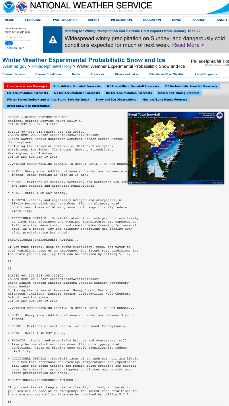
The storm total is right on the winter page. This is what I see when I go to my offices winter page…
-
You can all you want. I am here to try and clarify. Bitching here won’t get your feedback to where it needs to be.
-
1/19/25 Eagles Playoff Winter Storm obs
MGorse replied to Ralph Wiggum's topic in Philadelphia Region
Trouble multitasking? -
Send the feedback to my office. Bitching about it on here won’t do a damn thing!
-
There is nothing to fix. Read the times on the map. The storm total is on our winter page with winter weather headlines posted. The “additional snow” is in the text products when the forecaster chooses to do that especially when how much snow fell so far in areas is unknown (I tend not to agree with this as the storm total should still be included). Also, always check your local Point and Click forecast for the most updated amounts.
-
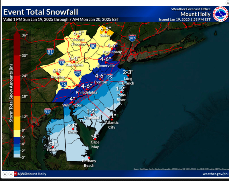
That goes by the next synoptic time which now is 00z/7PM. Here is the one that is the total from 1 PM.
-
1/19/25 Eagles Playoff Winter Storm obs
MGorse replied to Ralph Wiggum's topic in Philadelphia Region
Quite the interesting storm so far. I have snow flakes, snow grains and graupel all coming down at the same time. Surfaces coated up quickly. 32F -
Warning criteria for that area is 5 inches (that was changed from 4 inches several years ago).
-
Sunday 1/19 Eagles Game Snow and Stuff
MGorse replied to Ralph Wiggum's topic in Philadelphia Region
The evening shift made some adjustments to the snowfall totals. We will have another go at here on the overnight shift. -
Sunday 1/19 Eagles Game Snow and Stuff
MGorse replied to Ralph Wiggum's topic in Philadelphia Region
Geez, the clouds really cleared out this evening across much of the area and that resulted in fog/freezing fog in some areas. This also resulted in a much faster drop to the temperatures. Dew points have dropped a lot as well. Was not expecting the lack of clouds and fog. -
Sunday 1/19 Eagles Game Snow and Stuff
MGorse replied to Ralph Wiggum's topic in Philadelphia Region
The 00z 3km NAM still has a strong 850 mb FGEN band from about the I-95 corridor eastward Sunday afternoon to early evening. The 700 mb FGEN is farther north and west so nice tilt to the lift. This could get very interesting.