MGorse
-
Posts
2,280 -
Joined
Content Type
Profiles
Blogs
Forums
American Weather
Media Demo
Store
Gallery
Everything posted by MGorse
-
The visibility 1/4 mile or less?
-
Huh?
-
Probably a few inches on the high side.
- 1,105 replies
-
- 2
-

-
- tropics
- heavy rainfall
- (and 5 more)
-
Shocking!
- 1,105 replies
-
- 3
-
-

-
- tropics
- heavy rainfall
- (and 5 more)
-
Hazardous Weather Outlook issued by NWS Upton.
-
Advisory not a Watch.
-
Lightning, at least in our area, does not really start most wildfires especially since we typically don’t deal with dry lightning. The majority of fires around here are caused by humans.
- 1,105 replies
-
- 2
-

-
- tropics
- heavy rainfall
- (and 5 more)
-
NWS Mount Holly knows how dry it is, and the Fire Weather Watch has been upgraded to a Red Flag Warning for Saturday. As a reminder/FYI, the NWS fire weather products are for rapid fire spread and not for fires starting.
- 1,105 replies
-
- 3
-
-

-
- tropics
- heavy rainfall
- (and 5 more)
-
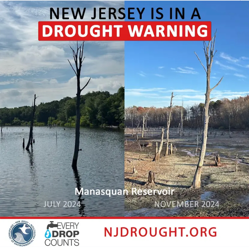
Drought Warning for NJ.

- 1,105 replies
-
- 1
-

-
- tropics
- heavy rainfall
- (and 5 more)
-
A total of 0.22 inches of rain at my house Sunday night. Rippage.
-
A whopping trace of rain here this morning.
- 1,105 replies
-
- 1
-
-
- tropics
- heavy rainfall
- (and 5 more)
-
31 for a low at my place early this morning, and yup still very dry.
-
There is a radar in Cherry Hill?
- 1,105 replies
-
- 1
-
-
- tropics
- heavy rainfall
- (and 5 more)
-
Low temperature of 37 here early this morning.
- 1,105 replies
-
- 2
-
-
- tropics
- heavy rainfall
- (and 5 more)
-
Trace of rain so far. Unreal!
- 1,105 replies
-
- 1
-
-
- tropics
- heavy rainfall
- (and 5 more)
-
Yeah how about that?
-
I don’t think it was subsidence, but more of the system being weaker and less organized.
-
0.04” total. Unreal!
-
Showers better increase big time overnight! A whopping 0.03 inches today here so far.
-
Perhaps be more patient. Some convection has developed in eastern PA toward northern NJ.
-
I am not a fan of these mid to upper 70s dew points!
-
It sure is humid out! Happy Independence Day everyone!
-
It was working just fine yesterday afternoon and night when some storms were moving through the Poconos, northern NJ and into parts of the Lehigh Valley.
-
Sharing the rain. Had a downpour. 0.11”
-
You wanna share please?