Alfoman
-
Posts
252 -
Joined
-
Last visited
Content Type
Profiles
Blogs
Forums
American Weather
Media Demo
Store
Gallery
Everything posted by Alfoman
-
Think that is right - this isn't necessarily digging more, but rather staying too positively tilted for too long.
-
Legit west based blocking/ - NAO on the long range OP GFS. Encouraging to see even tho in la la land
-
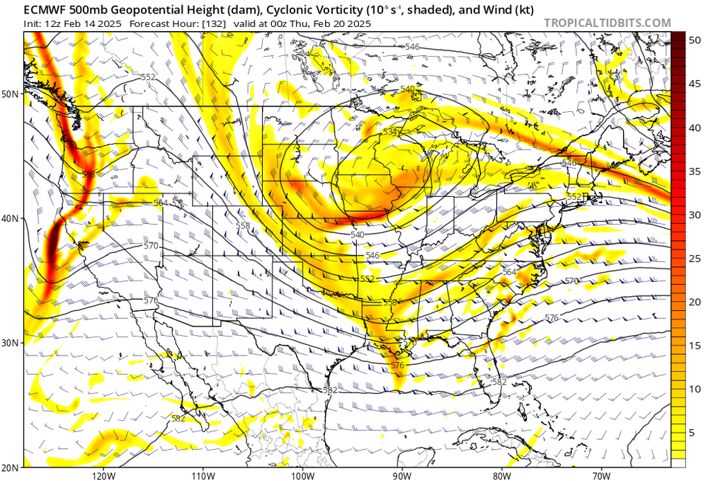
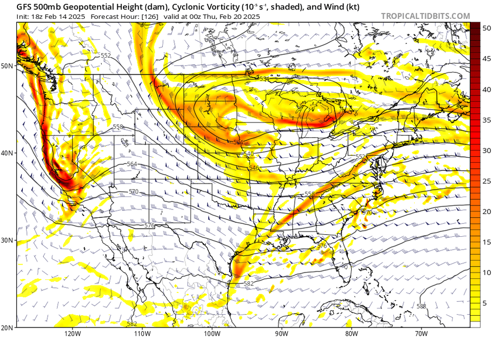
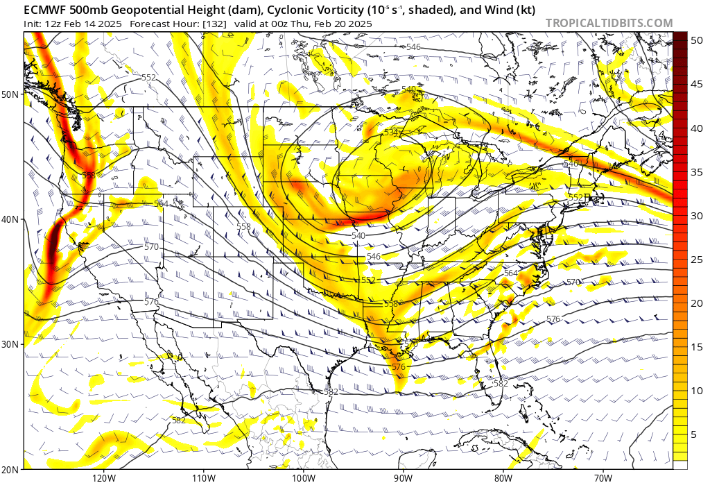
Oof didn't see the image of all the panel members, but it looks like under 2-3 legitimate hits for the 15th storm. Upper level progression is quicker, closer to 0Z result than 6Z which was a general improvement. Seems like the Ridge out west is more robust and pushing our trough along faster than we would want.
-
God this is gonna sting like a b*** when its all taken away by tomorrow
-
You're missing PDO cycle in the right part of its 6-10 year cycle and being in a solar minimum! Oh and for Ji to approve of the risk from the time it shows up 384 hrs out on the OP GFS...easy stuff to be honest?
-
With so much NS energy flying around, nothing will be clear about the upper level progression along with the trough next week for some time. I'm not giving up on the 15-16th timeframe until the weekend - even some light clipper action a possibility in the scheme of things.
-
From a trough out west to this...four days of slow positive progress by mid-month

-
Too little too late for the phase here but move that west and add a little tilt and we'd be in biz. Plenty of time to watch this one
-
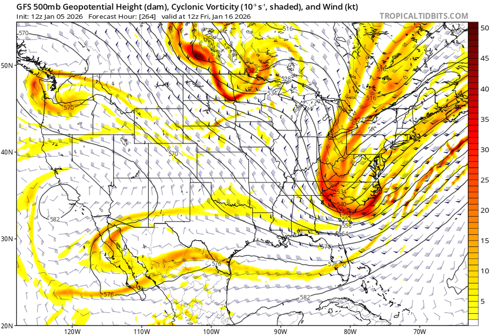
Agreed! And it's coming more in range, we're just outside of 200 hrs now with the onset of the 14th threat window. I don't think you can ask for more at this point in time than PNA spike in an optimal initial position out west with a few southern stream vorts dancing around a potential phasing situation. As it ALWAYS has been, we just need to get a little lucky. I don't expect ensembles to show huge totals until the details consolidate, but encouraging to see the amount of offshore coastal show up on the GEFS/EPS increase for 0Z. We've survived 5 days of 2026 without a distinct threat to follow, we can handle another few days.
-
Think the banter in here yesterday and this morning has been a bit restless and ridiculous to be honest. While there have been a number of rug pulls and pattern reversals over the years, seeing a window of opportunity line up in the mid-range with practically every index close to/in the correct quadrant is exceedingly rare. The beginnings of the NAO retrograde westward and Western US ridging are within the next 3-4 days, it is not a distant pattern change still in lala land. Getting the pieces to align and timing perfect so southern stream energy doesn't get squashed/sheared or that a phase doesn't only occur well offshore will ALWAYS be a struggle. We're hunting for a big dog coastal, it's a fragile balance. The stigma that we need a DGEX type solution every suite to overamplify every shortwave that comes through for us to feel confident...is irresponsible. We had plenty of rug-pull back then too, we just don't remember it as well because we hit more frequently than we have in the last decade. Look at the Euro AI if you want to feel something...three coastals in a row for the rough timeframes we have had pinned down for the last few days: 8th/9th, 10th/11th, 14th/15th. I expect the ensembles to start lighting up over the next few days at the least with some potential positive solutions.
-
0Z GFS looks like it reverted back closer to the 12z solution - more ridging out west and a more consolidated vort. However, us in the lowlands need this thing to dig more or it ends up being too warm
-
One of these shortwaves has to deliver a surprise eventually, right???
-
Ji, it’s the first day of the month man .
-
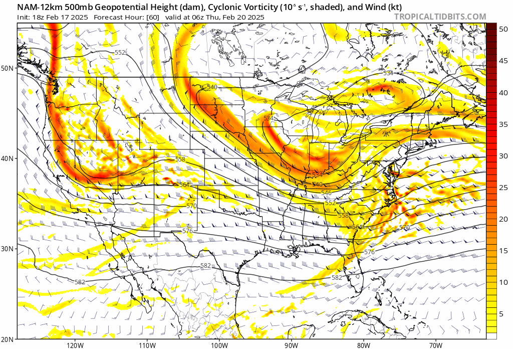
Delicate balance with amplification and placement of the low pressure off the coast with the GFS progression at 500. Would not worry too much into the details as of now, we just need the energy spacing to be close to where it is. GFS already doing it's classic energy getting sheared and held out for longer in the SW US though that we saw in the 120-180 hour range all too often last year.
-
One of the biggest caveats to the first week or two of December is the SE Ridge setting up as the cold slowly propagates eastward. While I do think it gets beat down as we head through the month, would likely hinder our chances for a bit. Hoping for a repeat of last year with the ridge amplification being grossly overstated in the long range routinely.
-
Would absolutely love some TV snow to start the season if we could get some wet flakes to fly...
-
BWI: 16.8" DCA : 13.9" IAD : 15.9" RIC :7.1" SBY:5.9"
-

Major Hurricane Melissa - 892mb - 185mph Jamaica landfall
Alfoman replied to GaWx's topic in Tropical Headquarters
I've been tracking hurricanes for two decades and nothing in the Atlantic has come close to the perfection, meteorologically speaking, that Melissa is achieving tonight. Absolute textbook steam engine...no words. -
Hilarious trend on the last three GFS runs - amplified, more ridging out west, phase with the NS in decent spot. Feel like we've seen the GFS do this around the 120-180 hr range just to slowly flatten/shear the energy over time as we get closer to the event. Rinse and repeat. CMC with a very different view of things - let's see if the Euro budges at all
-
That fluffy white powder
-
God we're grasping at straws but f it - we have nothing to lose. NAM shift is being caused by the spacing from the energy on the Pac Coat being pulled back. You can see the heights building between the TPV and SW out in Wyoming giving the TPV room to stay more West and deepen a bit further. CMC had a noticeable pullback of the energy out west as well - not really noticing much of a shift on the GFS tho. Regardless - too little too late for most of us, but hope it's on to something for once.

-
Don't forget that dews are going to be near 0 to start the precipitation tomorrow - it will take time and a considerable amount of precip falling first to saturate that column. Edit: up towards the DC area
-
It’s time we put some respect on the GFS’s name for standing firm the last [emoji[emoji[emoji638][emoji639][emoji[emoji6[emoji640][emoji638]][emoji640][emoji6[emoji640][emoji637]]][emoji[emoji638][emoji639][emoji[emoji6[emoji640][emoji638]][emoji640][emoji640]][emoji[emoji6[emoji640][emoji638]][emoji640][emoji640]]]][emoji639][emoji[emoji6[emoji640][emoji638]][emoji640][emoji6[emoji640][emoji637]]][emoji[emoji638][emoji639][emoji[emoji6[emoji640][emoji638]][emoji640][emoji640]][emoji[emoji6[emoji640][emoji638]][emoji640][emoji6[emoji640][emoji637]]]]]-[emoji[emoji[emoji638][emoji639][emoji[emoji6[emoji640][emoji638]][emoji640][emoji6[emoji640][emoji637]]][emoji[emoji638][emoji639][emoji[emoji6[emoji640][emoji638]][emoji640][emoji640]][emoji[emoji6[emoji640][emoji638]][emoji640][emoji640]]]][emoji[emoji[emoji638][emoji639][emoji[emoji6[emoji640][emoji638]][emoji640][emoji6[emoji640][emoji637]]][emoji[emoji638][emoji639][emoji[emoji6[emoji640][emoji638]][emoji640][emoji640]][emoji[emoji6[emoji640][emoji638]][emoji640][emoji640]]]][emoji639][emoji[emoji6[emoji640][emoji638]][emoji640][emoji6[emoji640][emoji637]]][emoji[emoji638][emoji639][emoji[emoji6[emoji640][emoji638]][emoji640][emoji640]][emoji[emoji6[emoji640][emoji638]][emoji640][emoji6[emoji640][emoji637]]]]][emoji[emoji6[emoji640][emoji638]][emoji640][emoji6[emoji640][emoji637]]][emoji[emoji638][emoji639][emoji[emoji6[emoji640][emoji638]][emoji640][emoji6[emoji640][emoji637]]][emoji[emoji638][emoji639][emoji[emoji6[emoji640][emoji638]][emoji640][emoji640]][emoji[emoji6[emoji640][emoji638]][emoji640][emoji640]]]]] days. We discounted it but it never fully wavered from its south and OTS solutions. Our shortwave is coming onshore out west shortly. I fear if the trends continue into [emoji[emoji638][emoji639][emoji[emoji6[emoji640][emoji638]][emoji640][emoji640]][emoji[emoji6[emoji640][emoji638]][emoji640][emoji640]]]Z we can call this one what it is.
-
It's pretty close but that strange elongated TPV with a more north orientation than the Euro is what causes this result. Honestly a good reminder how delicate the 500mb evolution can be for the resulting surface translation. Hope its wrong lol