Alfoman
-
Posts
252 -
Joined
-
Last visited
Content Type
Profiles
Blogs
Forums
American Weather
Media Demo
Store
Gallery
Everything posted by Alfoman
-
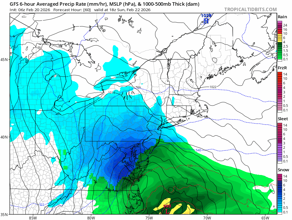
DC downtown keeps switching from a minute of light snow with rain mixed in to bursts of +SN, wild day of weather for the bday
-
Definitely a mixed bag in DC right now - flakes and sleet mixed in with light rain
-
12Z GFS is a straight firehose with temps and liquid from March 6th through 12th...brings like 9-12 inches of rain from the SE thru the Ohio Valley during that time. Honestly looking forward to a nice change in pace! Although I'm afraid the Cherry Blossoms are going to come out early this year only to be killed off but a random week of chill.
-

Outta gas and Outta Time: Early March Winter Storm finale
Alfoman replied to Ji's topic in Mid Atlantic
Yesterday morning lol -
Keep in mind though that temps are incredibly marginal in the DC metro and surrounding areas - would be a similar 33-35 and wet snow situation. Just not enough cold air to tap into here
-
The main fronto band slowly slipping away from the metro

-
I feel like there is a definite chance for a 3-5/4-6 incher towards the end of the month and into the first few days of March. Relatively quick and progressive northern stream, could see a quick hitter along the arctic boundary
-
Feb 22nd/23rd "There's no way..." Storm Thread
Alfoman replied to Maestrobjwa's topic in Mid Atlantic
Canadian going negative by 60 hrs - relatively similar to GFS trough orientation at 500 mb so far... I dare say this should be a better run? Edit: Still too warm but the dual low placement is improved - nod towards GFS once again -
Feb 22nd/23rd "There's no way..." Storm Thread
Alfoman replied to Maestrobjwa's topic in Mid Atlantic
12Z Canadian - trough is digging more and the tilt is more neutral rather than positive thru 54 hrs -
It's February 11th
-
If we just pulled a NS SW down on the CMC to phase a litttttttle bit, that run would've been lightning
-
I mean we're really NOT far from a positive solution here on the GFS, but we really need to get things right upstairs to make this one work. The margin for error is small here. We had the NE ULL in a much better spot and slower which would be our cold air feed - this followed the Euro trend for sure. More separation in the northern stream to our west as well but that that SW is not as robust as the 6Z Euro advertised. This along with a SW trend on our southern stream energy = no partial phase to bring this one up the coast. All I am saying is that it wouldn't take too much!
-
The Jan 31 Potential: Stormtracker Failure or 'Tracker Trouncing
Alfoman replied to stormtracker's topic in Mid Atlantic
Every trend you see on your screen is the wrong trend we would want lol -
The Jan 31 Potential: Stormtracker Failure or 'Tracker Trouncing
Alfoman replied to stormtracker's topic in Mid Atlantic
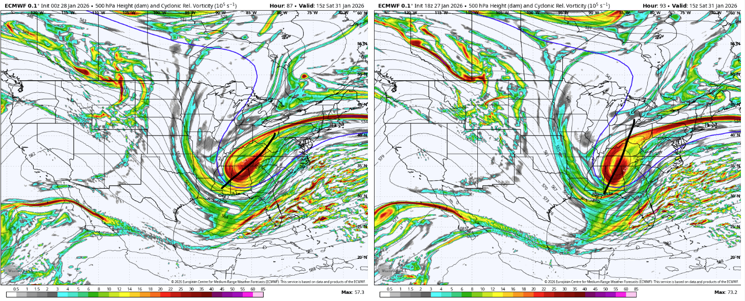
Trying to figure out why the Euro ended up with that surface translation even with more west ticks at 500: Looks like we just end up more positively tilted for longer (you can see the difference below at hr 87) and there is slightly worse spacing with the kicker out west. This one is going to drive us crazy with small shifts like that making the difference in the end.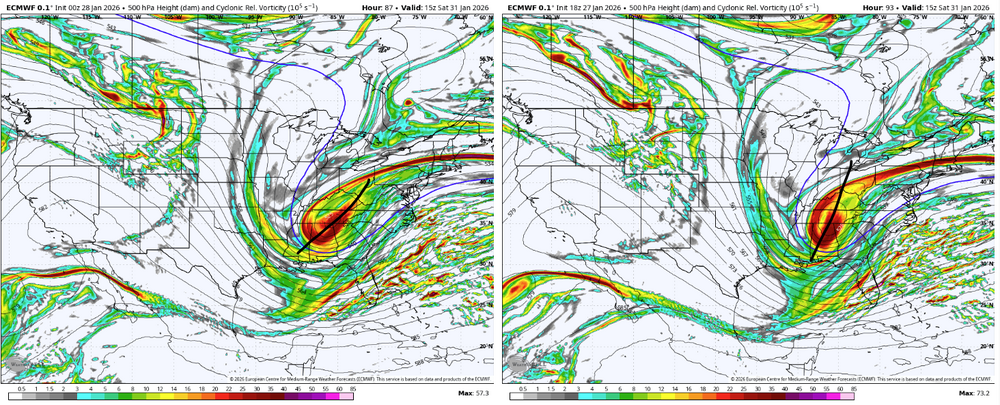
-
GFS first taketh and wrongeth, then GFS giveth
-
Lord Almighty (not done yet either)
-
GFS has not wavered from this trend in 24 hours...
-
Even if we miss out on the bulk of the coastal, we only need a few tenths of an inch of QPF to really generate some fun/meaningful powder given the arctic air being pulled in behind the storm
-
We got the CMC/E, ICON, and GFS/GEFS to improve run-over-run, no need to be perfect D5 as we very clearly found out this past week. Lots of ways to make this work even on a smaller scale than a HECS/BECS event like the 6z euro
-
That's why I caution this is delicate setup even if we eventually do get the low bombing off the coast at some point. Those smaller differences up top translate into huge surface-level shifts
-
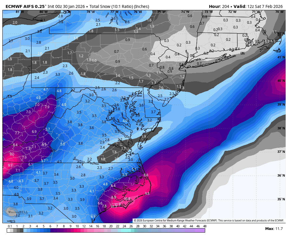
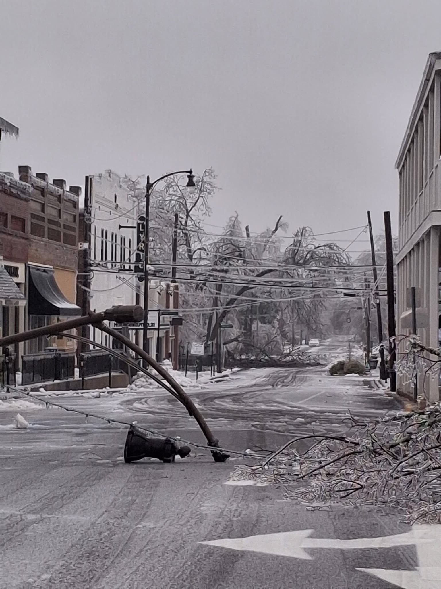
Boston has a chance to clear a top 10 storm for them, Boston to NYC could clear 3-4 inches of sleet when its all said and done, Crippling ice from Viriginia to Texas - very memorable storm overall. Pictures out of Oxford, MS are insane...

-
Pixie flakes in the middle of pouring sleet in DC proper...just an absolutely wild storm My hips are on fire after a long morning Jebwalk...this stuff is not an easy stroll
-
Jan 24-26 Weekend Snow and Sleetfest Model Thread Part Tres
Alfoman replied to H2O's topic in Mid Atlantic
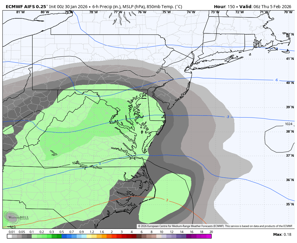
New Euro actually keeps the 700 mb column at 0 C or under in the district and above until between 20-21z on Sunday versus 17z on 6z suite -
Jan 24-26 Weekend Snow and Sleetfest Model Thread Part Tres
Alfoman replied to H2O's topic in Mid Atlantic
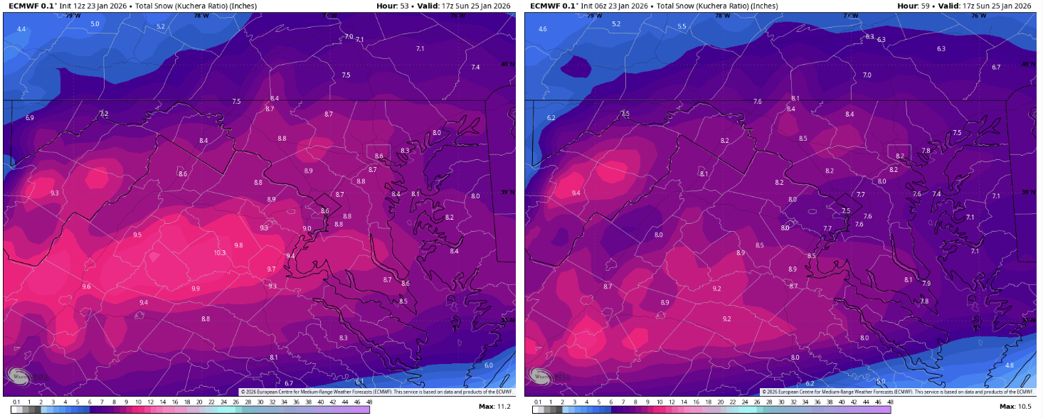
Euro Uptick on front thump (12z left, 6z right)