Alfoman
-
Posts
252 -
Joined
-
Last visited
About Alfoman

Recent Profile Visitors
3,138 profile views


-
DC downtown keeps switching from a minute of light snow with rain mixed in to bursts of +SN, wild day of weather for the bday
-
Definitely a mixed bag in DC right now - flakes and sleet mixed in with light rain
-
12Z GFS is a straight firehose with temps and liquid from March 6th through 12th...brings like 9-12 inches of rain from the SE thru the Ohio Valley during that time. Honestly looking forward to a nice change in pace! Although I'm afraid the Cherry Blossoms are going to come out early this year only to be killed off but a random week of chill.
-

Outta gas and Outta Time: Early March Winter Storm finale
Alfoman replied to Ji's topic in Mid Atlantic
Yesterday morning lol -
Keep in mind though that temps are incredibly marginal in the DC metro and surrounding areas - would be a similar 33-35 and wet snow situation. Just not enough cold air to tap into here
-
The main fronto band slowly slipping away from the metro

-
I feel like there is a definite chance for a 3-5/4-6 incher towards the end of the month and into the first few days of March. Relatively quick and progressive northern stream, could see a quick hitter along the arctic boundary
-
Feb 22nd/23rd "There's no way..." Storm Thread
Alfoman replied to Maestrobjwa's topic in Mid Atlantic
Canadian going negative by 60 hrs - relatively similar to GFS trough orientation at 500 mb so far... I dare say this should be a better run? Edit: Still too warm but the dual low placement is improved - nod towards GFS once again -
Feb 22nd/23rd "There's no way..." Storm Thread
Alfoman replied to Maestrobjwa's topic in Mid Atlantic
12Z Canadian - trough is digging more and the tilt is more neutral rather than positive thru 54 hrs -
It's February 11th
-
If we just pulled a NS SW down on the CMC to phase a litttttttle bit, that run would've been lightning
-
I mean we're really NOT far from a positive solution here on the GFS, but we really need to get things right upstairs to make this one work. The margin for error is small here. We had the NE ULL in a much better spot and slower which would be our cold air feed - this followed the Euro trend for sure. More separation in the northern stream to our west as well but that that SW is not as robust as the 6Z Euro advertised. This along with a SW trend on our southern stream energy = no partial phase to bring this one up the coast. All I am saying is that it wouldn't take too much!
-
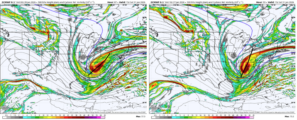
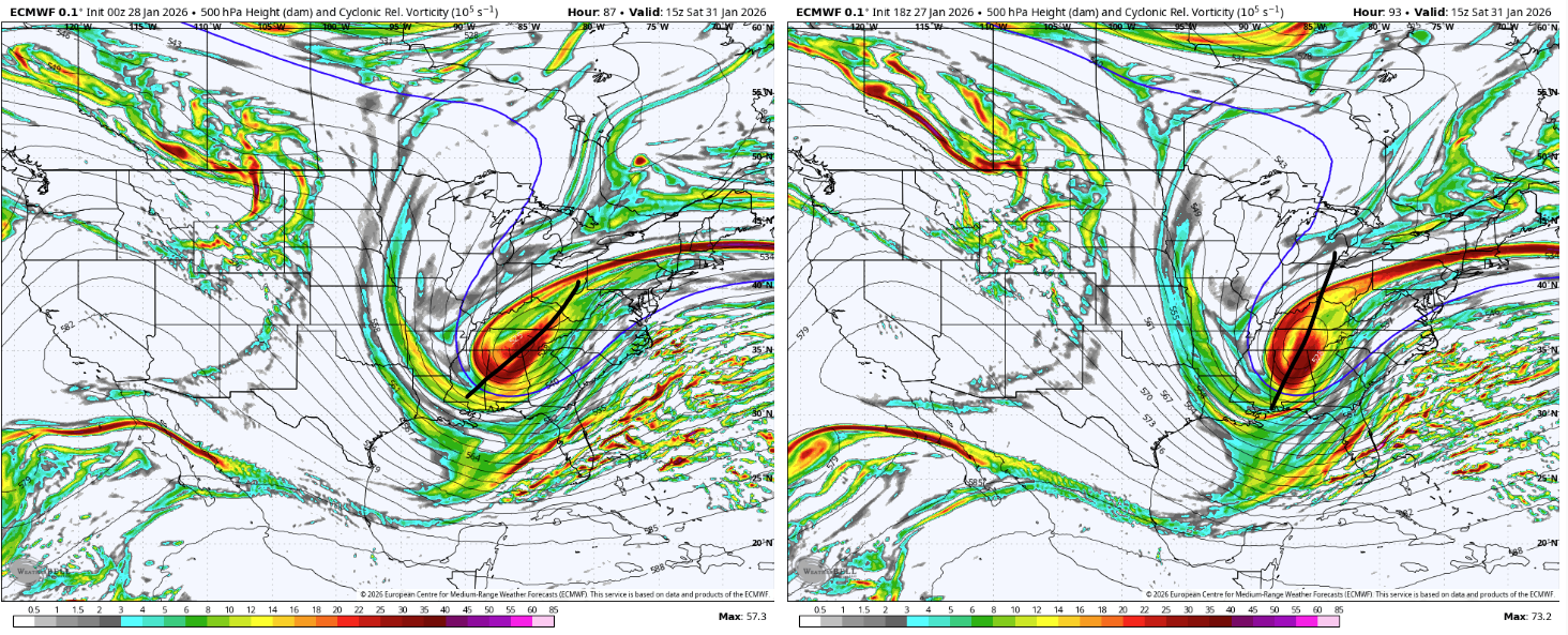
The Jan 31 Potential: Stormtracker Failure or 'Tracker Trouncing
Alfoman replied to stormtracker's topic in Mid Atlantic
Every trend you see on your screen is the wrong trend we would want lol -
The Jan 31 Potential: Stormtracker Failure or 'Tracker Trouncing
Alfoman replied to stormtracker's topic in Mid Atlantic
Trying to figure out why the Euro ended up with that surface translation even with more west ticks at 500: Looks like we just end up more positively tilted for longer (you can see the difference below at hr 87) and there is slightly worse spacing with the kicker out west. This one is going to drive us crazy with small shifts like that making the difference in the end.