

Ralph Wiggum
-
Posts
16,101 -
Joined
-
Last visited
Content Type
Profiles
Blogs
Forums
American Weather
Media Demo
Store
Gallery
Posts posted by Ralph Wiggum
-
-
I'm not liking what the CMC is cooking up
-
 1
1
-
-
We r going in reverse
-
 1
1
-
1
-
-
-
4 minutes ago, TowsonWeather said:
Brother, you're looking baller for 50. I turn 50 this year and I increasingly look like the corpse of Gary Busey.
Let's talk about buttered sausage
-
Only 90 ppl here
Light crowd, no pressure.
-
1
-
-
Just now, stormtracker said:
Home! Lfg
Bring it home. Cmon 0z!
-
See you guys late in the week for the Feb 25 system tracking.
-
1 minute ago, bncho said:
did we ever have the icon?
Yea, actually we did
-
Just now, Chris78 said:
Down to Euro and CMC.
Yep. Our 2 best pieces of guidance, so there's that

-
Just now, winter_warlock said:
Well it's the icon soo... lol
We are losing guidance one by one
-
1
-
-
1 minute ago, Chris78 said:
Doesn't look to hot
Clearly took a bow to the gfs
-
1 minute ago, bncho said:
probably some sorta "a5 wagyu" type shit
Yep. Japanese massaged grain fed champagne drank spoiled rotten cattle. Then slaughtered so Randy could devour it's carcass. Hope it was yummy.
-
4
-
-
129$ for a tomahawk steak?? What am I missing here? Did Salt Bae prepare it?
-
2
-
-
1 minute ago, Dendrimer77 said:
But you were served by the Lord Almighty himself! Totally worth it
Ninja'd
-
1
-
-
3 minutes ago, stormtracker said:
Christ almighty. Help. Valentine’s Day is a racket. I’ll be home in time for the GFS!
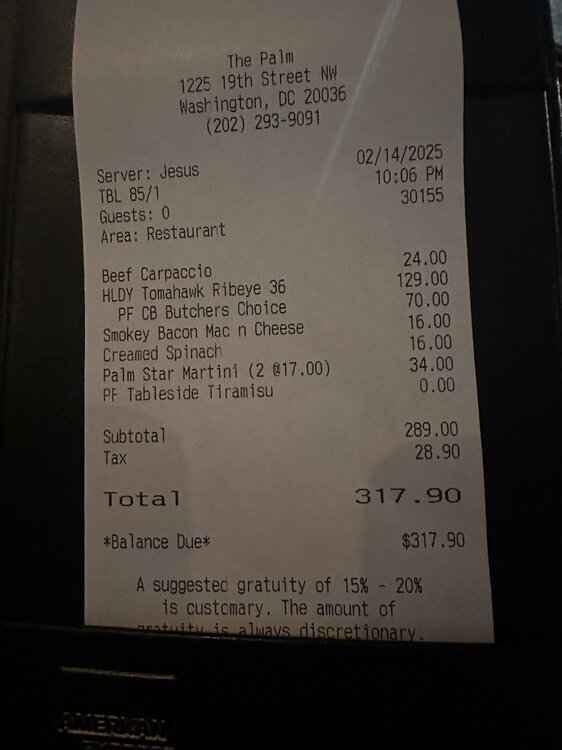
Jesus was your server? Oh hey now.....0z is gonna rock the omen can't get any better.
-
1
-
-
1 hour ago, Weather Will said:
WB 18Z AI fish storm....

The NAVGEM isn't even that progressive. Blow that model up that tesla ai self destructing pos
-
1
-
-
1 minute ago, RedSky said:
96hr NAM will be out at 10pm stay the course
Yo, you literally made me spit my beer out hahaha. Well played sir.
-
14 minutes ago, RedSky said:
Euro ai is sitting on the beach in Bermuda with a watermellon martini complete with the tiny floral umbrella laughing at us. It's so far away you can't not laugh.
I don't have a good feel about next week if I'm being totally honest and not the usual wiggum playing devils advocate sorta thing. We've been teased with the eps mega snow mean TWICE this season already, and both times, the mid Atlantic took the brunt and we got advisory type stuff.
We are in a Nina. And so far climo has played out with Delaware and South Jersey taking the bulk of the storms.
Why would this be different? Seriously, change my mind that this is going to morph into even a low-end MECS for SE PA? I just am getting bad vibes from the minute the GFS mirrored March 2001 last night. Prove me wrong.
-
 2
2
-
-
5 minutes ago, Heisy said:
But it did speed up the SLP. If it gets too far E before the N stream catches up it’ll be a GFS like scenario.
I need a dog
.Therapy dog? Lol
It will be alright. You can road trip to Millville probably and get it on another snowstorm for that area.
-
3 minutes ago, Heisy said:
At work so just seeing the euro. It sped up the southern stream just a touch and you see the result. Man synoptically it won’t take much either way for this to be a GFS or blizzard version. Brutal event to track for me for how this winter has gone.
Increased spread on 18z eps has me shitting bricks. I really hope the Ai comes back to at least giving us something FFS
Of course here in Philly that was like a 30”+ run we were still in the ccb at 144 hours
@Ji hold meGotta set your expectations based on Nina climo and seasonal trends. With that said, you and I need to keep our expectations low....very low. I am serious when I say that. This is a Mid Atlantic winter and this one is eyeing them up once again.
-
16 minutes ago, stormtracker said:
Dawg. Come on now.
Senior citizen early bird special type stuff
-
2 minutes ago, MDScienceTeacher said:
The fact that one is showing up is telling imho. That’s a signature of every big storm in the mid range. You start seeing this high total bullseyes right at the pivot point for the storm. I am just glad we are seeing one.
btw did you see the surface temps are at around 20 for these ccb panels.
Could have legit blizzard criteria in spots. Sustained winds would be the final ingredient
-
1
-
-
3 minutes ago, SomeguyfromTakomaPark said:
Yeah that’s like an 18 inch blizzard in the metros with a foot plus across the whole region.
I need @Solution Man sign here please image!!
I don't give a fuck who jackpots. Congrats. Just let me get in on a couple inches up this way. Not asking much, I'm not picky. Just about my beer.
-
1
-
-
3 minutes ago, Chris78 said:
Eastern areas are really in a sweet spot.
Nina climo ftmfw. My parents are retired in Cape May. I told them years ago ninas generally favor them vs my area.
So when I told them in Oct we may be going into a weak Nina they were look "shit, that means snow down here this winter". Hasnt disappointed yet.

February Medium/Long Range Thread
in Mid Atlantic
Posted
Much less amped, much lower heights out front. Won't do it imo.