

Ralph Wiggum
-
Posts
14,952 -
Joined
-
Last visited
Content Type
Profiles
Blogs
Forums
American Weather
Media Demo
Store
Gallery
Posts posted by Ralph Wiggum
-
-
3 hours ago, Duca892 said:
I am an absolute no nothing, but it looks like you can kind of walk away from model watching for the next 7-10 days before scoping out what is possible in February. Looks warm and rainy.
2 hours ago, JTA66 said:Sounds like it maybe as much as 2-3 weeks

We'll burn that bridge when we get to it. All the more reason to enjoy today!
GEFS and GEPS and EPS to a degree all have a small window around the 29th with a system tracking under us. Problem is antecedent airmass may not be too favorable. CMC and GFS op are close to something. Looks like a spring storm with higher elevations favored.
Looking out into fantasy land, weird to keep seeing something consistently popping up on the super extended stuff centered around Presidents Day. Big ones sniffed out early
 ?
?
-
 3
3
-
-
1 minute ago, jimmosk said:
Just went back out and did a second brushing, three and a half hours after the first. About 2.5" of fluffiness. Swarthmore's likely going to cross the 5" mark before this is done.
My buddy in Wallingford says 4.75" there so yeah, seems legit.
-
57 minutes ago, Birds~69 said:Bunch of spotters w/3" circle me w/a random 4"er so I'll go with around that.Probably go out shovel late this afternoon...stuff will get crunchy overnight and don't want to deal w/it tomorrow...27F/snow

I can confirm pockets of 4"+ around that general area.
-
Just snowblowed....4.25" in Ivyland. 27F. Looks and feels like winter. Exceeded expectations. Kudos to @MGorse and team at Mt Holly. Pretty much spot on!
-
 7
7
-
-
10 minutes ago, RedSky said:
Poking through guidance the venerable RAP is owning this storm go figure
Nothing else was close in my region anyway
The RAP is a classic. There is a reason it has withstood the test of time.
-
2
-
-
Really piling up now. Up to 3.2" in Ivyland. I can only imagine Philly is at or over 4" already based on radar.
-
1
-
-
22 minutes ago, Hurricane Agnes said:
Must be some kind of warm layer up in the atmosphere as I'm starting to get some pancakes mixed in with regular flakes (the fine stuff has been reduced to a min, although the pancakes will help increase the snow pack faster).
Temp is still 27 with dp now 26 with some fog.
ETA - running an animation of the radar suggests a band is back-building over I-95 so what might have appeared to be a "back edge" hasn't moved that much.
That's the effect of the ULL moving over and better dendrite growth.
-
Just now, jhotdog said:
Seems like back edge is approaching quickly. Is it supposed to back build at all? Up to 2” in Souderton.
According to guidance, yes. Heaviest now thru 2pm.
-
2" in Ivyland. We will pass the last event it appears. 26F and moderate snow.

-
3
-
-
2 minutes ago, Birds~69 said:
Definitely heaviest right now with stuff moving up...
Heavy Mod snow/lower clouds/25F

Puking snow in ivyland. 25F
-
1
-
-
ULL stuff now...better fluff factor. Probably 14:1 up here. Next 4 or 5 hrs is when we pile up and cash in. Enjoy!
-
3
-
-
Dunno man, S NJ and DE are dryslotted and best stuff is encroaching on SE PA. P's in Cape May said it had all but stopped. Half inch there. 1.1" here in Ivyland now.
-
4 minutes ago, Birds~69 said:
Yeah, hope it sets up there...flakes larger now.

Radar blossoming over Montco headed this way.
-
2
-
-
38 minutes ago, Kevin Reilly said:
Light Snow 26.4f humidity 99% dewpoint 26f pressure 29.79 wind NE 9 Total Snow so far 1.1"
Looking at radar looks like there is a focus with banding just north of the Mason Dixon line moving ENE.
South towards Baltimore and Washington kind of Meh and well north.
It's funny seeing the models try and hone on DE and SNJ but radar is suggesting otherwise.
-
3
-
-
How is Georgetown faring?
-
18 minutes ago, Maestrobjwa said:
Yes I see it's starting to pick up. What a treat to wake up to a potential BOOM scenario

Folks....
-
1
-
 1
1
-
-
2 hours ago, WxUSAF said:
We need to do this whole "forecast snow amounts double or triple in the final 24 hours before storm start" thing before our February HECS

You know as well as I do, the big storm will be the one to trend the wrong way. Murphys Law.
-
1
-
-
Lightest moderate snow ever here in Ivyland. 3/4 inch and 26F.
-
1
-
-
43 minutes ago, JSharp said:
I remember a Norlun trough in February of 2009 which setup over Philadelphia and Gloucester/Camden Counties. This sucker dropped up to 10 inches in the City of Philadelphia and up to a foot in Gloucester county. South of West Chester, where I live, only saw 4 inches. I think parts of Lancaster County (Manheim Twp.) got 12 inches in another very narrow band (10 miles wide).
I remember this. I lived in Delco at the time as was in the line and had 9" total snow. Amazing luck that night!
-
1
-
-
14 minutes ago, anthonyweather said:
18z icon.
Looking like 1-2” area wide but what do I knowI know you shouldn't be using a global model in situations like this where hi res is preferred.
-
1
-
-
28 minutes ago, Hurricane Agnes said:
I actually made it above freezing today, with a high of 33 (when the sun briefly attempted to show through the clouds), a low of 19, and a dp as low as 5 earlier this morning. I meant to tell RedSky that I "saw him" in the east around sunrise before it clouded over, so I knew something was on its way.

It's currently overcast and 30 with dp 19.
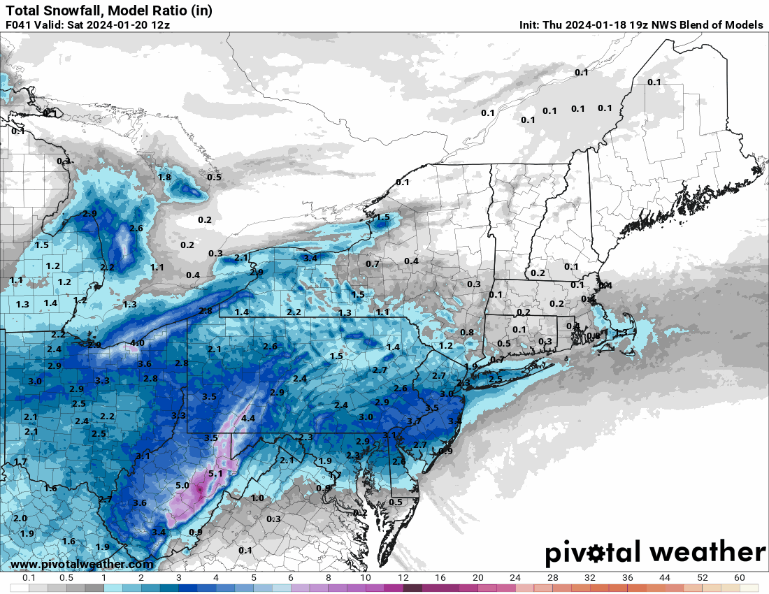
The 19z NBM seems to have the max accumulation right along the I-95 corridor. I suppose a concern might be if a dry slot appears, which I recall happening with past Norlun setups (with one area under a death band and others with zippo).
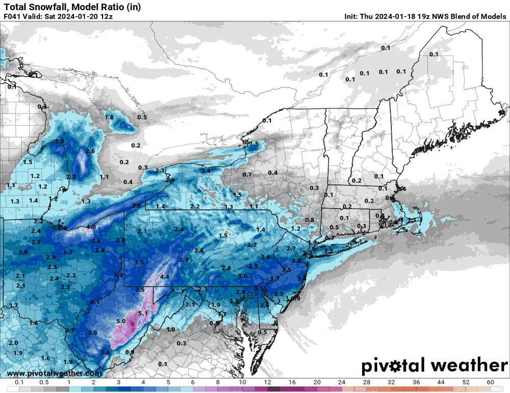
Yep. Area of subsidence is to be expected each side of the death band. That's why I loathe these setups. Clearly someone will be angry at the NWS when they get an inch or so and they 'were told 4-6"'. Wish there were a better way to make the general public wary of these IVT setups.
-
2
-
-
4 minutes ago, kickingupastorm said:
Any official thread for tomorrow’s storm…..??
-
WWAs and WSWs flying. Sitting at 31f in Ivyland.
-
3
-
 1
1
-
-
32 minutes ago, RedSky said:
Start timing continues to move up now it's closer to 5-6am
Don't sleep
-
2
-


January 2024 Banter
in Mid Atlantic
Posted
You'd better hope the Ravens decide to play ball control and especially ground game. Time of possession will be crucial in keeping the Texan offense off the field. You dont want to get into an aerial shootout against CJ Strout. I am confident the Baltimore coaching staff already has that factored into their game plan.