

Ralph Wiggum
-
Posts
14,952 -
Joined
-
Last visited
Content Type
Profiles
Blogs
Forums
American Weather
Media Demo
Store
Gallery
Posts posted by Ralph Wiggum
-
-
57 minutes ago, kickingupastorm said:
If we’re going with 4-8, why isn’t this WWA not bumped up to a WSW? Serious question.
Because it isn't widespread and those totals probably won't verify on the high end (6-8"), but we'll see.
-
A few buddies refer to me as 'weatherman'. With that said was just on a group call and they asked what to expect. So I said exactly as above, "really a general 1-3" but could be a 3-5" strip where the Norlun band sets up". The responses I got reminded me how much a weather nerd I really am.
-
 3
3
-
-
27 minutes ago, The Iceman said:
I wouldn't set my expectations that high... IVT's are notoriously tricky to nail down ahead of time. Could very well only be 2-3" if you miss out on that. Don't think anyone should go into this expecting 4-6".
Exactly. This is a general 1-3" type of setup. The higher 3-5" stuff will be wherever the banding sets up. Could n or s of the city still. We just can't know.
-
1
-
-
Bigger bust potential imho is coming in under the 4-6" for SE PA, not above that. Like ice said, we enjoy. Might be the last for a little while. Kids have a damn virtual day tomorrow. Most of us here were lucky to have a actuual snow days when we were young.
-
2
-
-
6 minutes ago, LVblizzard said:
Anyone see the 12z GFS for next Friday?
A page back
-
1 minute ago, LVblizzard said:
Is DT on crack or something? That is just a ridiculous map.
Fox29 seems a bit aggressive too. Hope these latest mesos s shifts/drier are just the windshield wiper effect and not reality.
-
1
-
-
48 minutes ago, JTA66 said:
As Agnes would say, it's ditty-bobbin' around.
-
 1
1
-
-
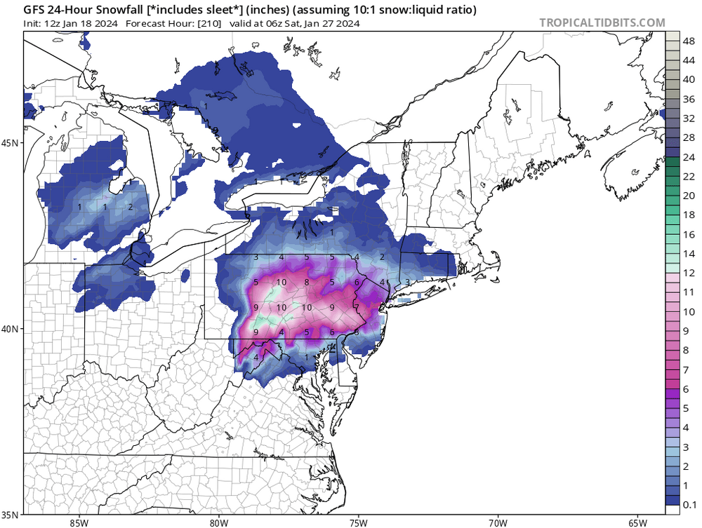
Something to watch later next week during the 'relax' pattern as it starts to transition. Several ops and ens members have been hinting at a well-time HP moving along the NE with good placement as moisture runs up from the South. Would take a good bit of things to go right, but since guidance had been hinting figured it was worth mentioning at least. Here's the GFS depiction:
-
3
-
-
55 minutes ago, hazwoper said:
Not based on the mesos, which should be used at this point for small features such as inverted troughs
Hrrr is 4-7"
3k targets Baltimore and pts south of the Mason Dixon
Fv3 is a non event
12k is 1-3"
Pick your poison. I choose a #1 with cheese....whopper time!
-
1
-
-
2 hours ago, The Iceman said:
Mt. Holly first call seems fairly bullish:
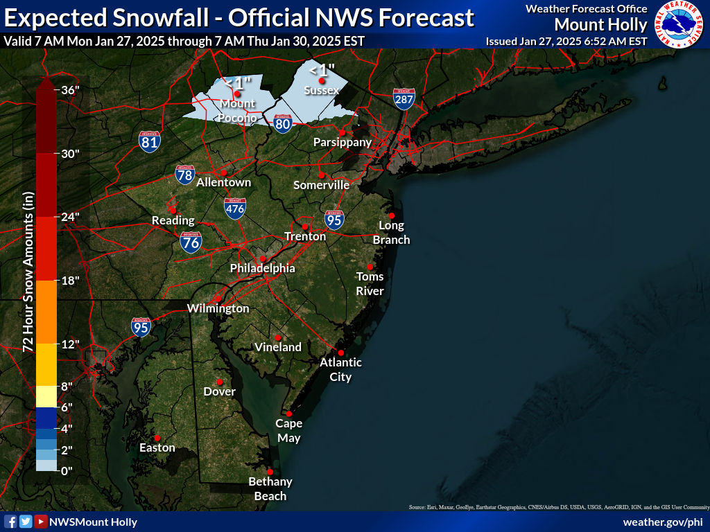
Take

-
28 minutes ago, SnowGoose69 said:
That has gotta be the worst +PNA/-EPO pattern I ever saw lol....I am not even sure if that technically qualifies as a +PNA but basically all the numerical GEFS have it as positive in that period. If you wanted to draw a map of how a +PNA/-EPO/neutral NAO/AO could screw you over, thats about as close as it gets.
I posted something similar in another thread without being quite as blunt about it, but was told it is a workable pattern and would just take some unconventional methods to work. Feb 15th - 26th is where we have our next legit shot after the light system Friday. Then lights out after that.
-
1
-
-
12 minutes ago, LeesburgWx said:
It’s almost Next worthy with these north trends. I’m buying the Icon though
"Guys", "folks", or "next'?
-
 2
2
-
-
7 minutes ago, cbmclean said:
Why because it might be dry like Ji mentioned?
Pretty much....at least to start out. As Chill noted, we probably dont shut off the stj but it gets shunted S and we wait for the relax or some renegade NS system. Better than a shit the blinds look, that's for sure.
-
12 minutes ago, Blue Dream said:
Most of the models seem to be targeting our area for the best snows...definitely take
Yeah, a bunch of afds from regional stations were saying this was either a dc-philly target or a philly-nyc target, so either solution has us getting something. We are a snow town after all
-
1
-
-
NAM is another 2-4" Friday. We take.
-
1
-
-
1 minute ago, stormtracker said:
Yeah, this isn't the direction we were hoping for. It's a drier run
Did you kill the original thread and start the new one? This is the range
-
1
-
-
1 hour ago, Ji said:
please dont show that map anymore unless there is blue over us
-
 2
2
-
21
-
-
1 hour ago, cbmclean said:
I like the +pna/-epo combo.
That is actually too much of a good thing verbatim. Though with the +NAO might wash. We just can't know.
-
6 minutes ago, nj2va said:
ICON has .3” QPF by 18z on Friday in DC (more to come). More than the NAM had the whole run.
Not bad for a model that is generally conservative with qpf.
-
1
-
-
Less confluence this run.
-
30 minutes ago, CAPE said:
PDIII

That's one of the better honks from the super LR models of the entire season. The lower Atlantic side height tendencies have been adjusting N. That is right where we want it.
-
1
-
-
33 minutes ago, osfan24 said:
Depressing that it looks like we might go another year without a HECS. We have to be closing in on the longest gap in between HECS that we have ever had.
And you can glean that from a weeklies or monthly model thru March?
-
4
-
-
7 hours ago, The Iceman said:
I’d fire everyone besides Big Dom and Stoutland. Maybe keep the special teams guy too.
Flyers look damn good.
-
RGEM is amazing for the area for Friday....regionwide 3-6". The good trends continue.
-
2
-


E PA/NJ/DE Winter 2023-2024 OBS/Discussion
in Philadelphia Region
Posted
Exactly. This does not have much moisture with it at all. And if we are counting on ratios to save us, remember it will be near 30, we aren't talking teens. 12:1 imo.