

Ralph Wiggum
-
Posts
14,952 -
Joined
-
Last visited
Content Type
Profiles
Blogs
Forums
American Weather
Media Demo
Store
Gallery
Posts posted by Ralph Wiggum
-
-
Should pickup a squall later in spots
-
 1
1
-
-
Loons like the dry slot has set up over my area in central Bucks and looks to continue per radar. Back edge zipping east fast See y'alll in the am. Goodnight and good luck.
-
1
-
-
Just now, RedSky said:
Did Albedo go to bed? Maybe
Probably thawing his drought gauge
-
 1
1
-
-
2 minutes ago, RedSky said:
Glad I have a witness to this I almost don't believe it myself
You guys are like 2 of about 8 people in the state that saw the good rates lol
Congrats.
-
1
-
2
-
-
-
Hrrr nailed it. To the North

-
13 minutes ago, Kevin Reilly said:
Mean time in other areas.... Yes, I am still waiting for my first flakes 34.2f humidity 50% dewpoint 19 pressure 29.85 falling wind ese 3 mph
Nothing notable here in Warminster. Dusting at best.
-
-
1 minute ago, RedSky said:
Dude I'm getting my .70" inches stop lol
Seriously, if you are near Q-town you are gold. Down this way, nasomuch. I expect 3-4" up your way without batting an eye.
-
Just now, RedSky said:
The latest SREF cut qpf in half, can't even believe it
Your .7" could be a struggle at the rate these trends are happening. Sheesh.
-
As soon as the WSWs get hoisted the SE zones go to complete shit. An inch or 2 now if we r lucky on latest mesos. Lets hope the NAM at 0z corrects this and NAMS us.
-
1
-
-
1 minute ago, RedSky said:
The RAP looks like the hrrrr and anybody have the 18z euro? Not liking the dry frame I saw.
18Z euro is N with the fronto band saw it in the MA sub.
-
1 minute ago, RedSky said:
A model that changes every hour eh Ralph
"It's trending"
-
1
-
-
3 minutes ago, RedSky said:
5" base ready for 4-6" more
Radar coming in hot I expect an early start time
My bar is set at 3" here. Let the games begin.
-
8 minutes ago, MN Transplant said:

-
-
10 minutes ago, Blue Dream said:
That model is crap Ralph
Under 17 hrs it isn't bad tbh. Guess what? Latest 22z ticked N again. We need plumes asap.
-
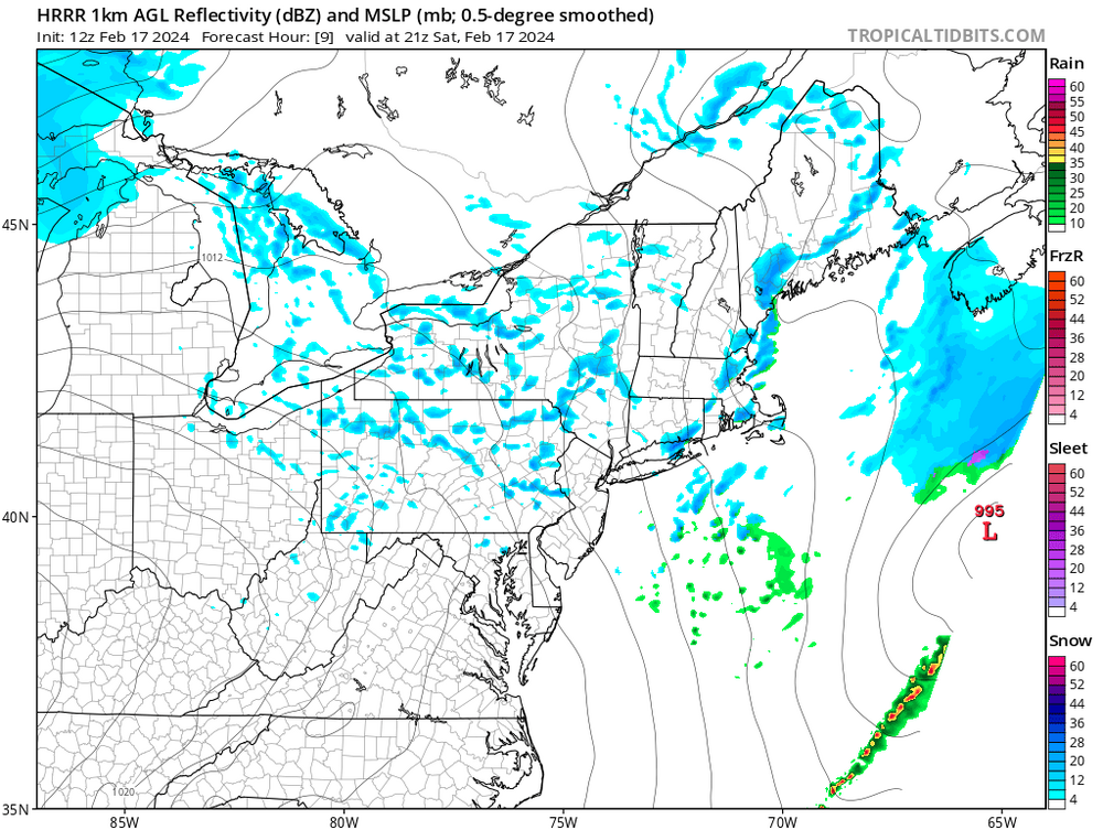
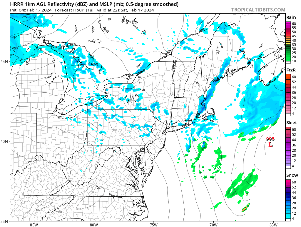
Hr³ Continues ticking N...now has S Bucks in the subsidence zone.
-
24 minutes ago, Mikeymac5306 said:
In like a Lion...

Nice tropical system east of the Bahamas there lol
-
1
-
-
1 minute ago, Duca892 said:
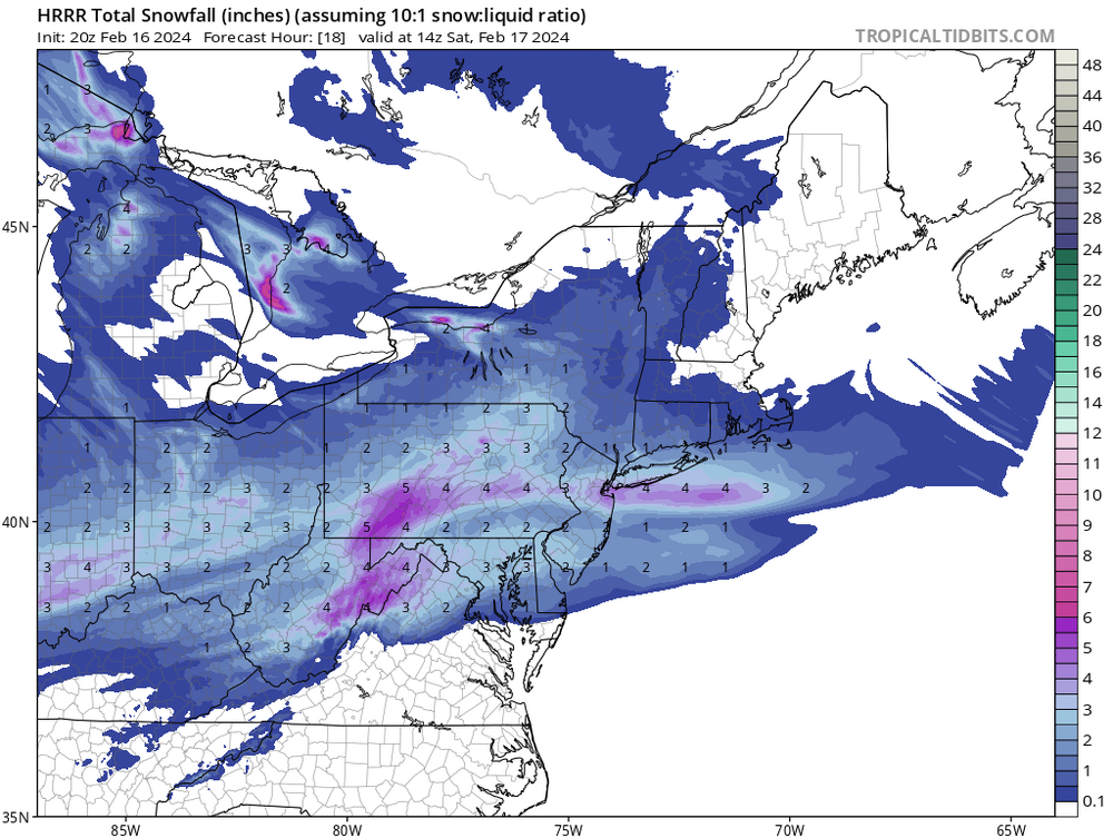
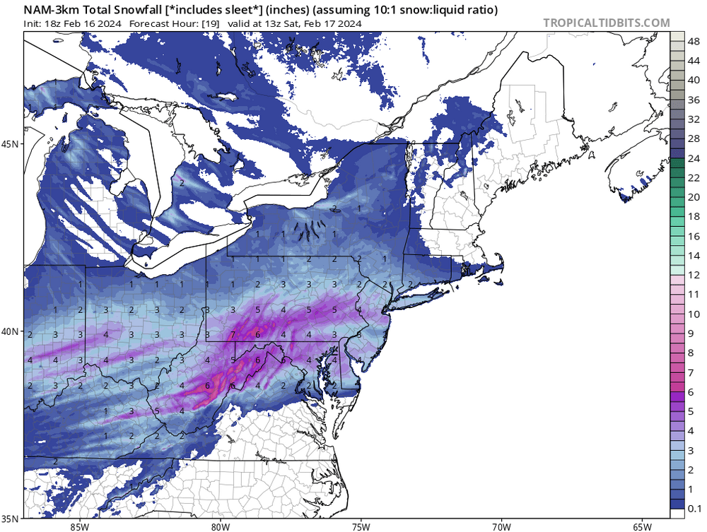
WWA updated in Lehigh Valley for 2-4in with locally 5in
How did this region end up as the snow capital of the East coast this season? Cool stuff.
-
3
-
-
Just now, snowwors2 said:
Well…
EPWA has heaviest for central and northwest Bucks!
Most guidance hitting those areas as ground zero and just S of there the subsidence zone. Makes sense.
-
1
-
-
1 minute ago, Prairie Dog said:
Winter Storm Warning
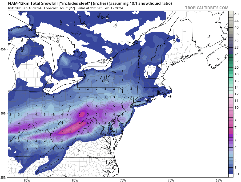
URGENT - WINTER WEATHER MESSAGE
National Weather Service Mount Holly NJ
328 PM EST Fri Feb 16 2024

DEZ001-NJZ016>019-PAZ070-071-101-102-104-106-170930-
/O.UPG.KPHI.WW.Y.0007.240217T0300Z-240217T1500Z/
/O.NEW.KPHI.WS.W.0004.240217T0300Z-240217T1500Z/
New Castle-Salem-Gloucester-Camden-Northwestern Burlington-
Delaware-Philadelphia-Western Chester-Eastern Chester-
Eastern Montgomery-Lower Bucks-
Including the cities of Wilmington, Pennsville, Glassboro,
Camden, Cherry Hill, Moorestown, Mount Holly, Media,
Philadelphia, Honey Brook, Oxford, West Chester, Kennett Square,
Norristown, Lansdale, Morrisville, and Doylestown
328 PM EST Fri Feb 16 2024

...WINTER STORM WARNING IN EFFECT FROM 10 PM THIS EVENING TO
10 AM EST SATURDAY...

* WHAT...Heavy snow expected. Total snow accumulations of 4 to 6
  inches.

* WHERE...Portions of northern Delaware, southern New Jersey and
  southeast Pennsylvania.

* WHEN...From 10 PM this evening to 10 AM EST Saturday.

* IMPACTS...Travel could be very difficult.

* ADDITIONAL DETAILS...Snow may briefly become heavy late tonight
  before tapering off early Saturday. Snowfall rates around 1.0"
  per hour or greater will be possible.
And we ride!....
-
2
-
-
33 minutes ago, The Iceman said:
18z NAM further decreases totals in extreme SE PA and South-Central jersey. Trending towards another melted by noon storm.
Whoever is S of that band thru N Bucks is going to fall victim to the subsidence. Could be a sharp cutoff between 5" and just an inch "or so".
-
18z NAM bumped totals in my area and up thru parts of the LV.
12k

3k

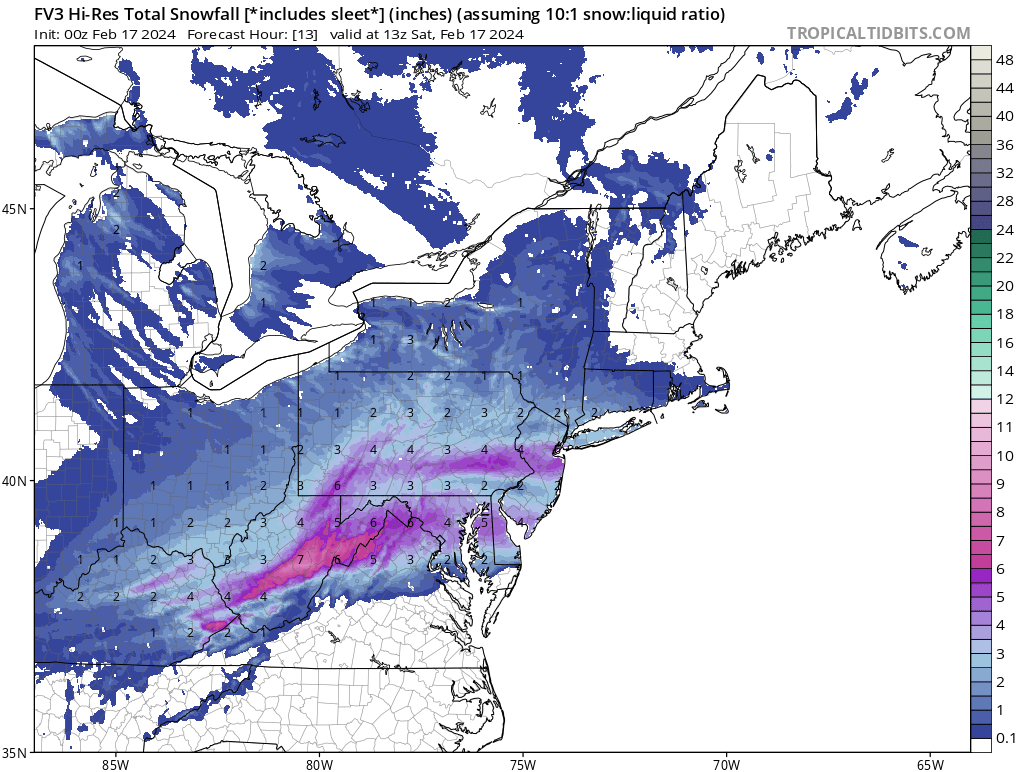

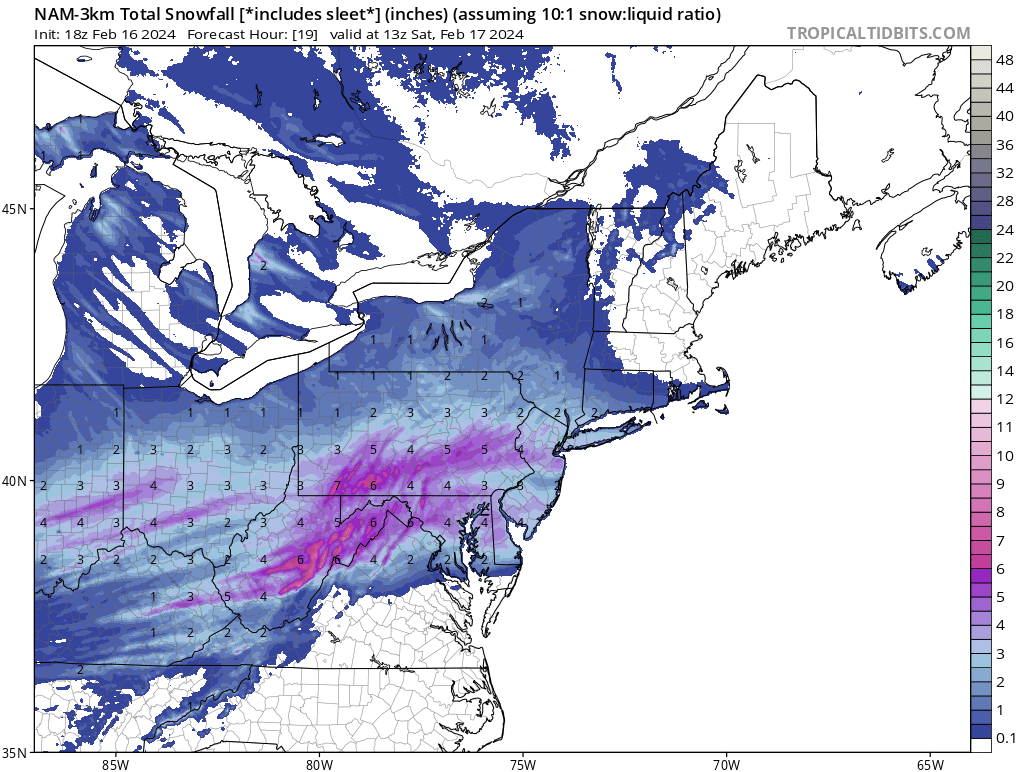
The Official Unofficial Overnight February 16/17th Snow/OBS Thread
in Philadelphia Region
Posted
Well, expectation was set at 3" here and ended with 3" on the button in Ivyland. No complaints. Just under 18" for the season and 6z GFS says maybe we get another shot late week.