Ralph Wiggum
-
Posts
17,384 -
Joined
-
Last visited
Content Type
Profiles
Blogs
Forums
American Weather
Media Demo
Store
Gallery
Everything posted by Ralph Wiggum
-

E PA/NJ/DE Spring 2026 Obs/Discussion
Ralph Wiggum replied to PhiEaglesfan712's topic in Philadelphia Region
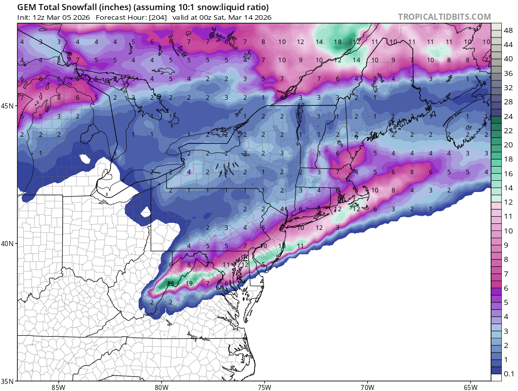
And a light followup event a day later. Weenie run: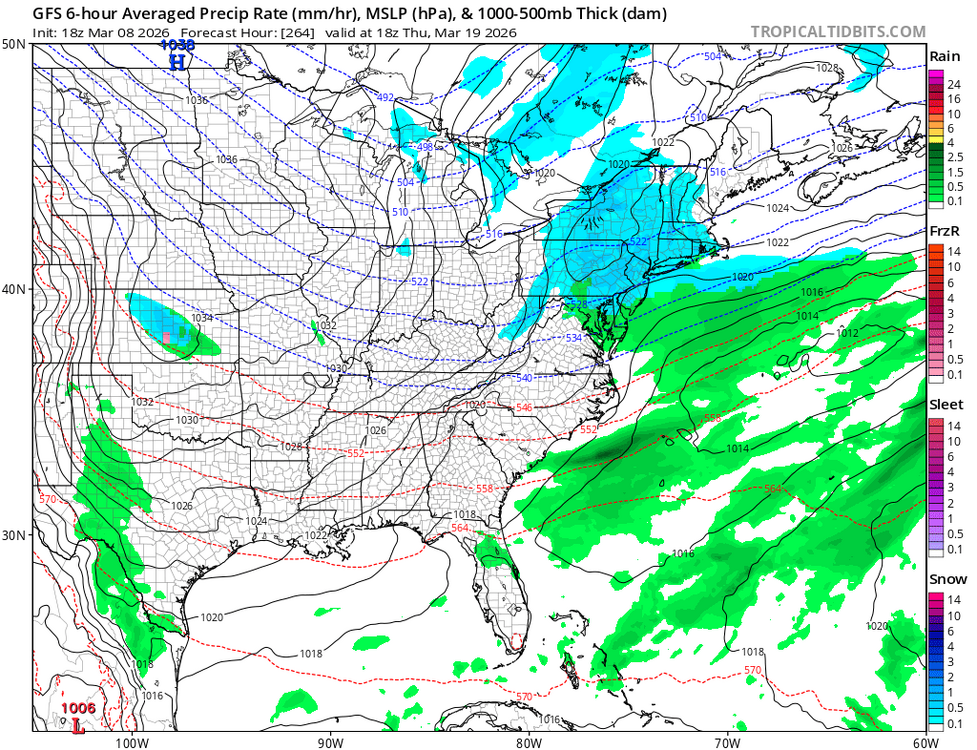
-
E PA/NJ/DE Spring 2026 Obs/Discussion
Ralph Wiggum replied to PhiEaglesfan712's topic in Philadelphia Region
18 gfs says we track:
-
E PA/NJ/DE Spring 2026 Obs/Discussion
Ralph Wiggum replied to PhiEaglesfan712's topic in Philadelphia Region
Are we really doing this?


-
Ivyland (Warminster), PA: A
-
E PA/NJ/DE Spring 2026 Obs/Discussion
Ralph Wiggum replied to PhiEaglesfan712's topic in Philadelphia Region
We got boomers. Welcome spring! -
E PA/NJ/DE Spring 2026 Obs/Discussion
Ralph Wiggum replied to PhiEaglesfan712's topic in Philadelphia Region
Are we doing this?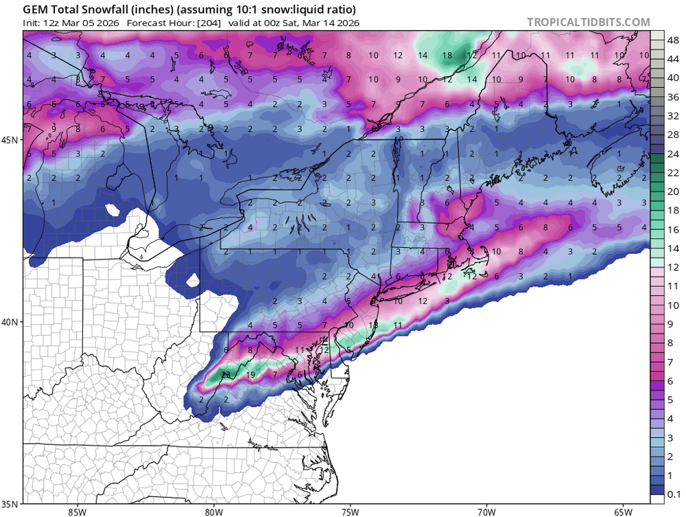
-
E PA/NJ/DE Spring 2026 Obs/Discussion
Ralph Wiggum replied to PhiEaglesfan712's topic in Philadelphia Region
Final grade for winter for mby is a solid A. Final answer. -
E PA/NJ/DE Spring 2026 Obs/Discussion
Ralph Wiggum replied to PhiEaglesfan712's topic in Philadelphia Region
This is a much better post from you. Nobody is arguing that warmth is coming nor arguing that it is definitely going to snow in March. The disagreement is with your concrete and certain statements that "it will hit 70 in the first 7 days of March guaranteed" and "we will never see another snowflake this year, bank on it" type of one-liners. Youre a good poster when you back your stuff up with facts like you did here ^^ -
E PA/NJ/DE Winter 2025-26 Obs/Discussion
Ralph Wiggum replied to LVblizzard's topic in Philadelphia Region
Snowing in Cape May. -
E PA/NJ/DE Winter 2025-26 Obs/Discussion
Ralph Wiggum replied to LVblizzard's topic in Philadelphia Region
Tomorrow AM btw:
-
E PA/NJ/DE Winter 2025-26 Obs/Discussion
Ralph Wiggum replied to LVblizzard's topic in Philadelphia Region
I'll be ready for striper fishing in the Delaware in a few weeks. No need for this stuff. -
E PA/NJ/DE Winter 2025-26 Obs/Discussion
Ralph Wiggum replied to LVblizzard's topic in Philadelphia Region
-
E PA/NJ/DE Winter 2025-26 Obs/Discussion
Ralph Wiggum replied to LVblizzard's topic in Philadelphia Region
Beware the Ides of March: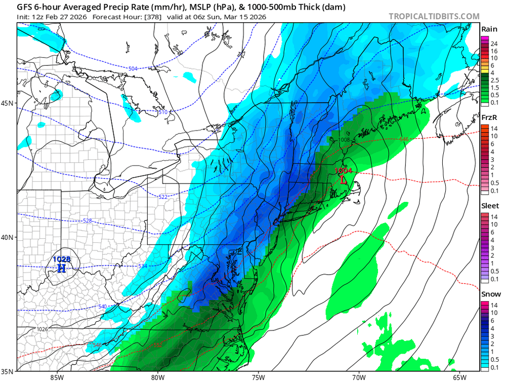
-
E PA/NJ/DE Winter 2025-26 Obs/Discussion
Ralph Wiggum replied to LVblizzard's topic in Philadelphia Region
Which winter month didnt we have snow? Dec 13 storm, Jan 25 storm, Feb 22 storm. You're butthurt because it didnt snow when it was 0 degrees for that 2 week stretch? We had it all this winter my old friend. Minus a significant fzra storm. I give it an A for sure. Im on the fence adding the + We dont get winters like this one very often. This was rather rare territory tbh. Try geritol -
E PA/NJ/DE Winter 2025-26 Obs/Discussion
Ralph Wiggum replied to LVblizzard's topic in Philadelphia Region
Your posting hopefully -
E PA/NJ/DE Winter 2025-26 Obs/Discussion
Ralph Wiggum replied to LVblizzard's topic in Philadelphia Region
It was a good winter, no complaints. Snow threat next week shit the bed and the warmup looms the following weekend just in time for Daylight Savings time. Bring on spring!! -
Outta gas and Outta Time: Early March Winter Storm finale
Ralph Wiggum replied to Ji's topic in Mid Atlantic
So after last weekend we gonna bet against the gfs? -
E PA/NJ/DE Winter 2025-26 Obs/Discussion
Ralph Wiggum replied to LVblizzard's topic in Philadelphia Region
I am fine with this and then touching 70 by the following week. Would be a fitting finale to a really good winter! -
E PA/NJ/DE Winter 2025-26 Obs/Discussion
Ralph Wiggum replied to LVblizzard's topic in Philadelphia Region
Euro is exactly where we want ... weak and a little south with the bullseye. -
E PA/NJ/DE Winter 2025-26 Obs/Discussion
Ralph Wiggum replied to LVblizzard's topic in Philadelphia Region
Eps lighting up for the grand finale next week -
E PA/NJ/DE Winter 2025-26 Obs/Discussion
Ralph Wiggum replied to LVblizzard's topic in Philadelphia Region
Half inch here. Gefs are a go for next week -
E PA/NJ/DE Winter 2025-26 Obs/Discussion
Ralph Wiggum replied to LVblizzard's topic in Philadelphia Region
I know it won't look a thing like that map in 144 hrs, but the precip extending from Cali to the NJ coast is a sight to behold. -
E PA/NJ/DE Winter 2025-26 Obs/Discussion
Ralph Wiggum replied to LVblizzard's topic in Philadelphia Region
Atmospheric river -
E PA/NJ/DE Winter 2025-26 Obs/Discussion
Ralph Wiggum replied to LVblizzard's topic in Philadelphia Region
GFS is on a hot streak. Are you sure you want to question it? -
E PA/NJ/DE Winter 2025-26 Obs/Discussion
Ralph Wiggum replied to LVblizzard's topic in Philadelphia Region
6z euro if it went out past 144 would drive the developing waa precip into our region with HP centered over Toronto. Probably a good thump to mix scenario.