

CT Rain
-
Posts
25,962 -
Joined
-
Last visited
Content Type
Profiles
Blogs
Forums
American Weather
Media Demo
Store
Gallery
Posts posted by CT Rain
-
-
Just now, ORH_wxman said:
Hrrr is def less IVT. Consolidating quicker. Nice to see that trend from 18z reverse at least on one model.
Better for sure but man is it warm initially with that IVT over the city.
-
 1
1
-
-
Turning pretty ugly pretty fast for many south of the Pike.
-
1
-
-
Turning into a nightmare south of the Pike.
-
 1
1
-
-
Just now, WinterWolf said:
Why was Wiz saying it looked great in CT?
Great for Ginx and his sand bags.
-
1
-
-
Just now, Damage In Tolland said:
What about this one yesterday? Reasonable ?

I disagreed with that. The overnight one was low but within the range of reasonable solutions.
-
 2
2
-
-
6 minutes ago, 78Blizzard said:
Based on that BOX map, they are riding their own private model.

They don’t use clown maps. It’s not an unreasonable solution given the overnight guidance. That said there’s a whole lot of spread.
-
8
-
-
3 minutes ago, Thunderblizzard said:
CMC almost trying to show some kind of valley convergence in CT, lol... that'd be the day. Clown map with like 31" in East Hartford.
We take
-
3
-
-
Just now, Snowcrazed71 said:
But I'm guessing it's not happening as depicted.
It's the perfect phase/setup. Can't be ruled out.
-
2
-
-
Just now, ORH_wxman said:
NAM is like classic KU with all the features for SNE.
Epic.
-
2
-
-
Just now, Spanks45 said:
Wow....sitting at hr 48, thing of beauty.
Yeah that's an incredible solution for CT.
-
4
-
-
I'd pay $100 to get the NAM to verify IMBY.
-
2
-
1
-
-
6 minutes ago, ORH_wxman said:
When I looped h5 on the 06z euro, I def expected heavier QPF than what it showed. But it was a step down from 00z.
It’s going to be a significant storm, but the difference between a HECS type blizzard and a fairly heavy late season snow event (but nothing earth shattering) is going to come down to if we have those truly exceptional rates for hours on end.
Even the H7 evolution is nice and keeps the dry slot away.
Bit of a strange evolution on the euro with the southern stream going so far offshore before coming back.
-
1 minute ago, Damage In Tolland said:
Could you see needing to raise totals as possible?
Sure anything is possible.
-
1
-
-
4 minutes ago, Ginx snewx said:
Tru dat
.thumb.png.51e625ced060b6bfa99b18f28c1cd255.png)
By that point the storm is rapidly winding down.
-
9 minutes ago, Damage In Tolland said:
I think overall it's just sort of a weird setup with a lot of caution flags. I could see things becoming a bit disjointed here in CT and needing to lower totals.
-
1
-
-
Just now, Damage In Tolland said:
Could you answer my question I asked earlier when you can?
What was your question?
-
1 minute ago, Damage In Tolland said:
Subsidence in Weha?
I'm not expecting a whole lot here anyway
-
Just now, Ginx snewx said:
Thru 84
.thumb.png.540e26b104b5985abfee742e2e199427.png)
Aren't 10:1 clown maps virtually useless in a storm like this? Idk why they're getting so much play here.
-
3
-
-
Subsidence in Tolland?

-
3
-
-
8 minutes ago, Johnno said:
Working the Sunday am shift damn lucky Darren on vaca lol
Yeah at least the forecast is exciting and keeping me awake!
-
1
-
-
10 minutes ago, Ginx snewx said:
Forgot your Eastern 700 to 800 foot hills again. East Killingly Killingly Sterling 6 to 12? At 600 to 800 ft
I didn't really. I think longitude helps some for W CT.
-
3 minutes ago, Sey-Mour Snow said:
Seems like a great map to be based on the enormous uncertainty. I almost feel like anyone that doesn’t l get in the “heavy banding ” during the daylight hours Tuesday won’t get much so it’s like 6-12”+ or just white rain ..
I will enjoy my 6 hours of cat paws that never accumulate!
-
1
-
-
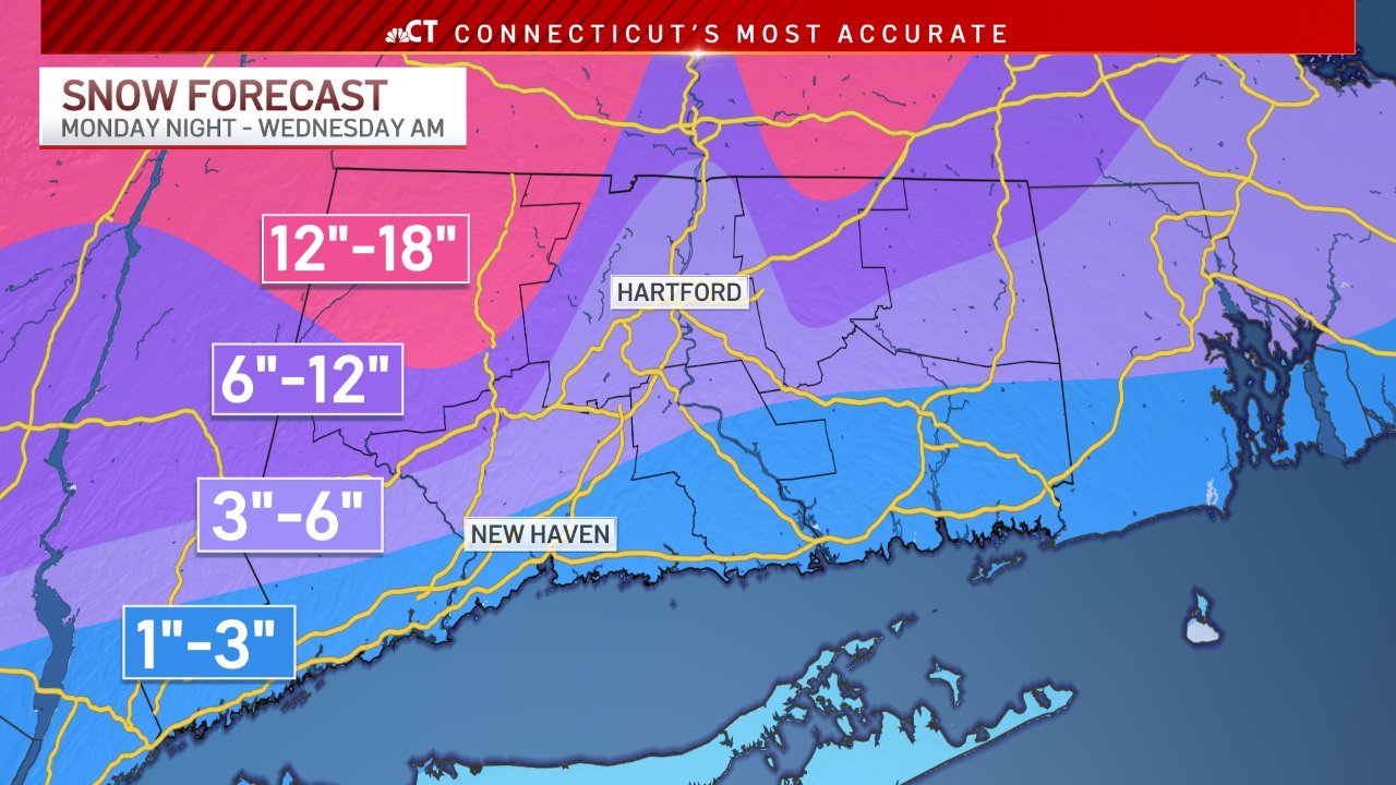
Here's our forecast. Pretty tough call but this is the best I could manage for the time being lol
-
3
-
1
-
 2
2
-
-
GFS looks pretty much identical 0z to 6z. That inverted trough really screws us south of the Pike for a while.
-
1
-
.png.3fdcba20cf62ca9be9a50f95572a69ea.png)
.png.0ffce463d2d40aa3f02de0919b1d8d04.png)
The last hurrah? Putting all the eggs in the Tuesday 3/14 basket
in New England
Posted
I'd prefer it to the Euro trash solution.