

CT Rain
-
Posts
25,946 -
Joined
-
Last visited
Content Type
Profiles
Blogs
Forums
American Weather
Media Demo
Store
Gallery
Posts posted by CT Rain
-
-
30 minutes ago, Typhoon Tip said:
Cape's a new tornado alley ... seems the last 8 years has had a lot of those lowered LCL deals
Raise SSTs a few degrees every summer and suddenly things become fun.
-
 1
1
-
-
1 minute ago, weatherwiz said:
Seems like any potential for a strong or severe storm tomorrow is like 6 AM - 12 PM and probably moreso eastern Connecticut, Rhode Island, and eastern Mass. Should see a widespread 1-2'' of rain tomorrow within this outline area as well and probably some narrow strips of 3-4''.
Seems to me like the environment is pretty favorable along the warm front all the way back into NJ/NYC and coming northeast from there through daybreak.
-
1
-
-
Just got my Epic pass. Let's do this!
-
1
-
-
Just now, TalcottWx said:
Scanners had dozens of trees down etc, I guess I should have specified the severity of the damage.
Only 2600 eversource outages... pretty meh. Looks like a lot of 40-50 mph gusts.
-
1 minute ago, CoastalWx said:
Ryan said there wasn’t. Kind of meh overall.
Very meh. Not many reports at all given radar.
Radar velocities were very impressive off ALY/BOX but a lot of that was aloft and didn't mix down. Given the strong LLJ not surprised to see strong winds picked up aloft but am surprised we didn't see much in terms of damage.
-
1
-
-
44 minutes ago, andyhb said:
Feel like the low magnitude of deep layer shear and iffy mid-level lapse rates/lack of an EML are going to curb this a fair amount. Would assume messy storm mode.
Especially the 18z/00z runs so far have really done a number on the lapse rates. Interestingly lots of 0-3km CAPE but really meager 500-700hpa lapse rates.
Deep layer shear isn't awful... particularly pre-18z... with 30-40 knots.
We'll see for sure... curious to see how the morning convection shakes out and if we can get a bit of discrete action ahead of the main show.
-
1
-
-
The soundings on the NAM and Euro remain extremely impressive tomorrow across SNE. HRRR a bit less so but we certainly could see a few spinners and maybe even a sig tor if things break right.
-
2
-
 1
1
-
-
7 minutes ago, Torch Tiger said:
 awful ML lapse rates combined with cloud debris/garbage can ruin it

lol what a disaster that was
-
 1
1
-
-
39 minutes ago, weatherwiz said:
Now that's a better tornado wind profile
Although LCL is a bit high with an inverted V look which would reduce potential somewhat.
anyways though, not trying to downplay anything. That is one potent s/w which moves right across the region with unseasonably strong dynamics. What we really need to watch are the lapse rates. H5 is a bit on the warm side (-7C) as is H7 (+10C) and this shows up well with those warm bubbles on the soundings. If we can get lapse rates even 6.5 C/KM this could be a widespread event consisting of swaths of wind damage.
LCLs are extremely low on that sounding.
-
2
-
-
5 hours ago, Modfan2 said:
I mean I think you’re off on the dews, anything over 70 was humid and 50-60’s slightly uncomfortable. When you have lows at night in there 50’s and low 60’s that’s not too uncomfortable with the windows open. Being in S FL for a few years gives you an appreciation of what Heat and dews are like.
Thanks, almost threw up listening to @CT Rainstation this am; when did “feels like” temp trump actual forecast temp? I mean I get it, feels like temp sells better on the morning and evening news. Stop already, feels like is extremely subjective but I guess feels like 98 sells better than an actual temp of 88.
The NWS uses it to determine what gets a heat advisory or warning so it's not totally a media invention lol
-
2
-
-
Euro and NAM wind fields on Thursday are worth watching, Wiz.
-
3
-
-
42 minutes ago, Torch Tiger said:
Deranged.
-
2
-
1
-
8
-
-
42 minutes ago, CoastalWx said:
Yeah Saturday needs to be watched especially ORH east.
Yeah the NAM is hideous.
-
 1
1
-
-
Thankfully everything has been fairly progressive so far which has helped with the flood threat. We'll see how it shakes out later today.
-
4
-
-
Just now, Hoth said:
If I see his truck floating in Long Island Sound, I'll let you know.
The entire neighborhood may fall victim to a mudslide.
-
1
-
-
Just now, weatherwiz said:
There’s definitely going to be at least a narrow swath of significant totals tomorrow in the 6-8” range but it’s just a matter of how widespread that swath is and what are the highest totals. The degree of lift over the region aided by a pretty intense ulvl jet and llvl theta-e is going to be bad news.
Not to mention soils are saturated, rivers and streams are running very high, etc.
-
2
-
-
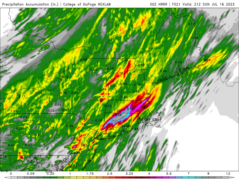
The 3km NAM has been showing some very impressive bullseyes too - just all over the place with location. The 18z run had 13" of rain near Albany lol
-
1
-
-
Not gonna lie - this is a frightening look.
-
4
-
1
-
-
Could be a pretty significant flood event tomorrow for someone in SNE based on the 12z runs.
Can't rule out a tornado either if some areas destabilize event given the strong low level shear.
-
1
-
-
4 minutes ago, weatherwiz said:
What's really intriguing tomorrow too is there is a bit of an EML that moves overhead. It's not a classic EML but breaks off from the mid-West.
Yup. Lapse rates are steep.
-
1 minute ago, weatherwiz said:
Oh I already am
I've made a few posts...was thinking of doing a thread. I was originally more excited for upstate NY into VT but this even looks good across western MA and NW CT. Planning on maybe chasing tomorrow evening.
Albany is probably the best spot ~20z.
-
Waiting for Wiz to get excited for tomorrow. Nice looking CAPE and low level shear late tomorrow afternoon through evening for E NY and western New England. Definitely some tornado potential there.
-
3
-
-
2 minutes ago, CoastalWx said:
Euro sucks for the weekend.
Ugly
-
 1
1
-
-
25 minutes ago, Damage In Tolland said:
Dews up to 68 now. BOX knew
KHFD 111653Z 26005KT 10SM CLR 30/17 A2983 RMK AO2 SLP102 T03000167
August model and weather disco
in New England
Posted
Yup that's been the risk all along. The global models have been consistently south.