

CT Rain
-
Posts
25,946 -
Joined
-
Last visited
Content Type
Profiles
Blogs
Forums
American Weather
Media Demo
Store
Gallery
Posts posted by CT Rain
-
-
1 minute ago, ma blizzard said:
Just want to leave this here .. if we ever want to question if this model is good

The problem is half the ensemble members are time lagged so you're getting 50% of that mean coming from 12z runs and 50% from 00z runs. When there's a dramatic shift the utility of the HREF is definitely more limited.
-
 3
3
-
 4
4
-
-
1 minute ago, ORH_wxman said:
I don’t think it’s going to end up well here. 00z hrrr trended worse for the second straight run after improving between 18z and 22z. Just about ready to throw in the towel here on anything over 6”.
CT/RI/SE MA still look ok but these flatter runs are robbing dynamics too so even the places that still get hit aren’t get hit quite as hard as when we see the more dynamic/north solutions.
Yup... HRRR looks worse. Blahh.
-
Not much of a change from 12z to 18z on the EPS
-
13 minutes ago, FXWX said:
How are you feeling about southern Fairfield County?
They should do well. 8 or 10 for most?
-
1
-
-
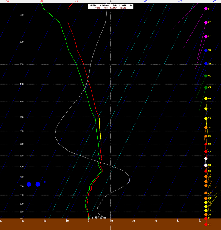
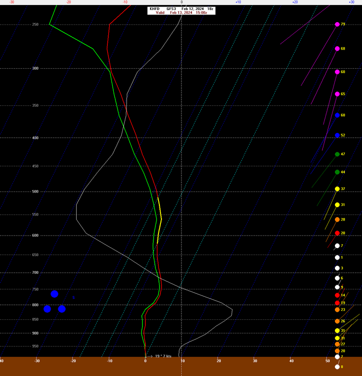
FWIW - the 18z GFS, 18z NAM (12km and 3km) still show excellent snow growth for BDL/HFD. Even on the QPF gradient the efficient dendritic growth could help.
-
5
-
2
-
-
Just now, ineedsnow said:
18z is a good step in the right direction
A bit of a bump. At least the trend has stopped.
-
1
-
-
24 minutes ago, ORH_wxman said:
Yeah I've been expecting S trends but these aren't as bad as I was thinking....that's still a big fronto sig from like HFD/Kevin over to BOS....the trends are concerning, but there's def still a good banding potential there on that run.
Even looking at the 19z/20z HRRR there's a great banding/snow growth signal through most of CT up through boston.
-
4
-
-
-
4 minutes ago, Brian5671 said:
Wonder how fast forecasts catch up -most of the public thinks a monster is coming....school supers with the finger on the cancel button.....no school for white rain lol.
I think it still looks pretty good for you guys and most of S CT
-
1
-
-
Good lord. What a disaster.
-
1
-
 2
2
-
-
1 minute ago, CoastalWx said:
Bands into CON and slots SNE lol.
Toaster Bath
-
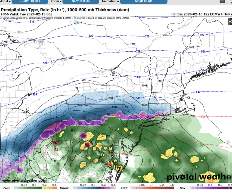
Here's our first call. Only thing I don't like about the 18z GFS is that it brought the 700mb low a bit farther north. Have to watch that south of the Pike I think.
-
6
-
 1
1
-
-
1 minute ago, ORH_wxman said:
Don’t think so
2m temps are a bit warm on the Euro for valley/shore at the onset. Kevin would be fine of course.
-
1
-
-
Just now, ORH_wxman said:
Definitely gotta keep that in the back of our minds. I don’t honk it has room to fully phase but a little more partial phase wouldn’t be out of the question.
Yeah a partial phase would send this pretty far north. Definitely don't want any more of that south of the Pike.
-
5 minutes ago, 40/70 Benchmark said:
This is why he is 5PPD.
What a strange way to live your life. Just posting on a weather board trying to troll people about snow. Imagine having the time to be so lame?
Anyways the GFS looks great. That confluence to the north is going a long way here in making this event an actual event.
-
5
-
1
-
1
-
-
1 minute ago, qg_omega said:
This is mostly rain or white rain for the coast, temps are awful with a spring elevation storm vibe yet again
Did you even look at anything or are you just trolling?
-
5
-
1
-
-
Just now, CoastalWx said:
Probably a fronto crush near nyc to the cape
I like how the h5 low closes off a bit as it moves offshore. A couple days ago it seemed like the thing was sort of shearing out and dampening some.
-
1 minute ago, Damage In Tolland said:
There shouldn’t be much of a north trend
OK

-
6
-
 1
1
-
-
That improved confluence to the north increases the risk of suppression but it definitely helps with better cold air source and even better frontogenesis with a stronger baroclinic zone.
Sort of playing with fire but I like the look now a lot better than 2 days ago.
-
6
-
1
-
-
5 minutes ago, 40/70 Benchmark said:
Yea, I agree with Wolf that there is some overattribution, but I don't feel like this is an example of that...its a pretty egregious case.
No doubt overattribution along with some junk science (the stuff from Jennifer Francis has been pretty widely debunked, for example). But there's some stuff that seems pretty clear.... it's not much of a mystery as to what's happening.
-
6
-
-
2 minutes ago, 40/70 Benchmark said:
60" snow storm has absolutely zero to do with the fact that the world is comprsised if like 70 water and said water is warmer than it ever has been.
The fact that warmth holds more water isn't debatable.
And it's more than just that too... lower static stability over warm(er) waters, potential for stronger baroclinicity along the coast sometimes with a higher base state in water temps. Lots of second order effects here.
I think there's a pretty strong case for an increase in the severity of some winter storms in the NE US/Atl Canada among other things (decrease in snow depth days, etc).
-
5
-
-
4 hours ago, Sugarloaf1989 said:
I skied at Ski Sundown last night for my adaptive skiing lesson. At first I tried a mono ski. But I couldn't balance myself with my arms and kept falling over. So we switched over to there brand new Rossignol Snow Cart.
This cart let's me lye down and control the ski's with poles. I can snowplow, turn and brake to control my speed. Unfortunately I can't use it solo as the base is spring loaded for boarding a chairlift. The chairlift has to be stopped for loading.
We took 3 Runs down from the summit. Tom's Treat, Canyon and Nor'Easter. It felt good to ski these trails again. I got some speed on these trails. There a nice group of people. Very friendly and Patient. My next lesson is on February 7th.

That's awesome. Glad you had a good time and can't wait to see more!
-
1
-
-
3 minutes ago, STILL N OF PIKE said:
Yesterdays report showed Whistler had 62” depth at top and 2” at bottom . Lol
I was there last year and it rained every day in the village and was sunny in the alpine. 0" base in the village and >100" in the alpine.
It's the craziest weather variation I've ever seen day in and day out.
-
1
-
-
3 minutes ago, Angus said:
Where were you? spent xmas there.
Whistler
-
1
-

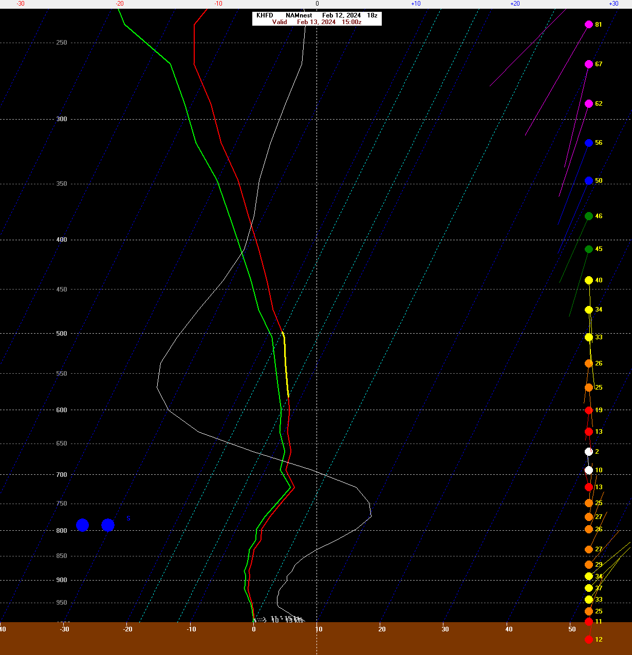
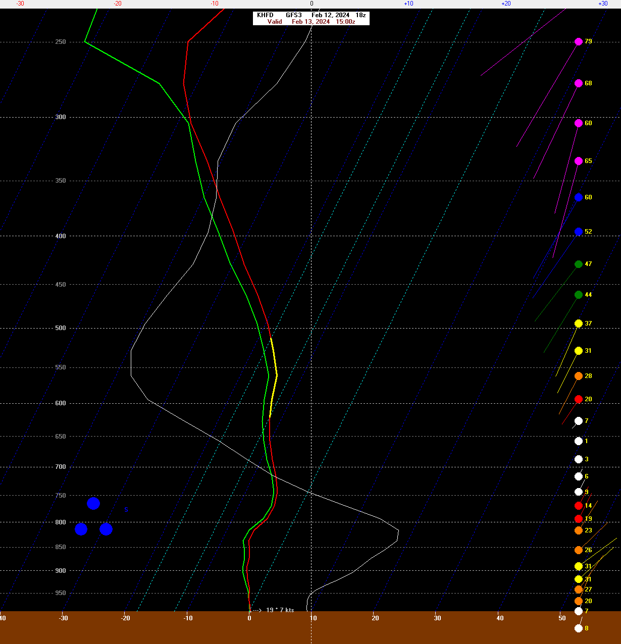


Following a Miller A/B hybrid type coastal potential, Feb 13th ... As yet untapped potential and a higher ceiling with this one
in New England
Posted
GFS is south a bit but still good for the south coast. Seems like a bit of an outlier at the moment.