

CT Rain
-
Posts
25,946 -
Joined
-
Last visited
Content Type
Profiles
Blogs
Forums
American Weather
Media Demo
Store
Gallery
Posts posted by CT Rain
-
-
2 minutes ago, TauntonBlizzard2013 said:
Box went wild. Not sure anything really warrants that
It's pretty close to the 50th percentile NBM (which is also spitting out 16:1 or 17:1 ratios in RI and E Mass).
-
 2
2
-
-
Just now, Damage In Tolland said:
Thursday night/ Friday snows look like that 30:1 fluid where you can grab 3-6” from like .15-.20
30
 for you
-
 3
3
-
-
4 minutes ago, wxsniss said:
Just starting to look at this in more depth, but to your point, interesting to see variance on 12z EPS in low depths hinting at the very different ceiling with a "subsume" setup:
Jan 17 range is generally 980s-990s
Jan 19-20 have a few members as low as 950s-960s
Was thinking the same thing. There are a few Tippy stemwinders coming right up over SNE sub-970mb.
-
1
-
-
-
3 minutes ago, CoastalWx said:
He was. Silly him!
It's confusing following a million weenies on Twitter!
-
1
-
10
-
 1
1
-
-
Just now, ineedsnow said:
not bad lol
Humidity 66% Wind Speed SE 29 G 78 mph Barometer 28.99 in (981.8 mb) Dewpoint 37°F (3°C) Visibility 10.00 mi Wind Chill 39°F (4°C) Last update 9 Jan 9:56 pm EST Downsloping off the Tug Hill?
-
2
-
-
12 minutes ago, OceanStWx said:
PEO gust to 63 knots. Real man stuff back in CNY.
Even better in Watertown!
KART 100256Z AUTO 14025G68KT 10SM SCT110 09/03 A2899 RMK AO2 PK WND 14068/0252 SLP818 60001 T00890028 56130
-
3
-
-
6 minutes ago, CoastalWx said:
Yup, agree.
Also 3km NAM is showing widespread 50-60 knot gusts around DC at 21z. Not happening.
-
5 minutes ago, weatherwiz said:
Yup...it's coming.
I'm shocked wind isn't being played up more. It gets hyped up when it it will be a non-event and then not hyped up when it will be a big event.
It's essentially going to be like a 85 mile wide EF-0 ripping through the region
Soundings do not look conducive to a damaging southerly wind event. Certainly nowhere near as impressive as the 12/18 event.
If we get damaging wind it would be from a QLCS but there's very little instability modeled. I don't see much in most areas the way it looks right now.
-
3
-
 3
3
-
1
-
-
I don't see much of a damaging wind threat. Soundings look far more inverted than the last couple events.
-
4
-
2
-
2
-
-
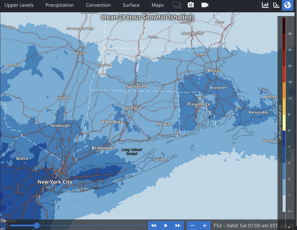
7.0" here in West Hartford. Waiting for round 2 to begin!
-
4
-
-
1 minute ago, WxWatcher007 said:
Euro is pretty robust with part two tomorrow in CT.
Yeah was just thinking the same thing.
-
3
-
-
Over 4" here in West Hartford and ripping.
-
3
-
-
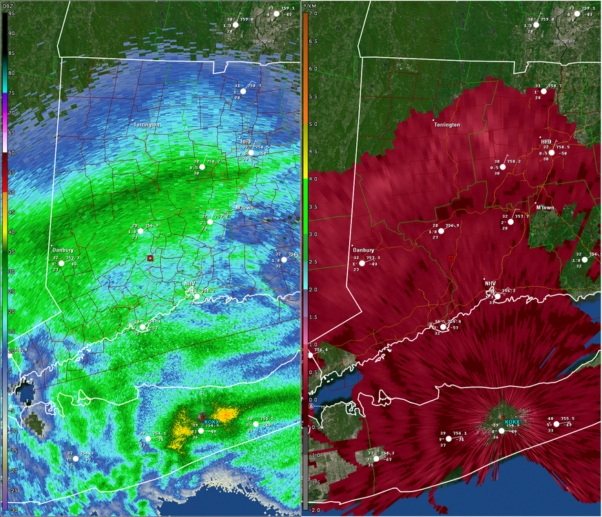
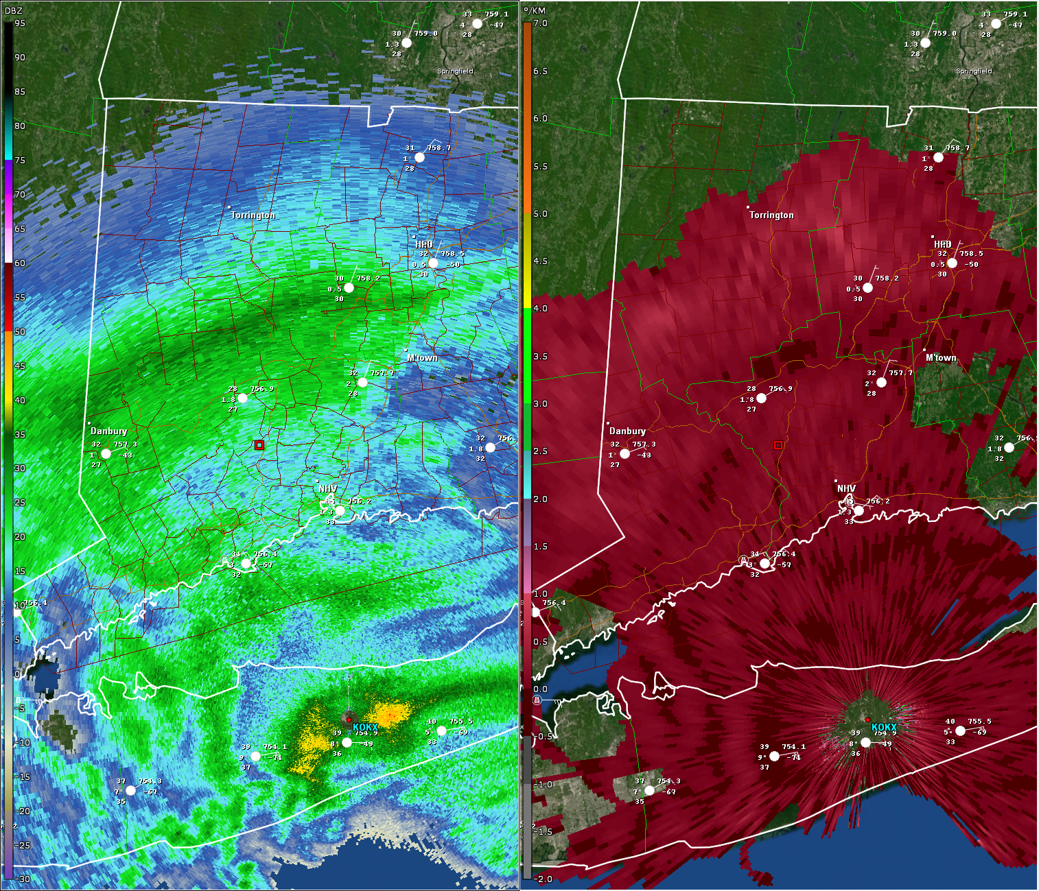
KDP shows some exceptional dendritic growth in that band from near Hartford all the way back to NW NJ. If you look up into the DGZ (~15kft up) you can see KDP values occasionally reaching 1deg/km which tells you you're getting some exceptional snow growth. Big time reports under that band in NW NJ and SE NY... hopefully parts of CT can cash in.
-
4
-
-
Some 9"/10" reports in NW NJ. That band put down a ton of dendrites from NW NJ into SE NY (and probably NW CT too).
-
3
-
-
Just now, WinterWolf said:
Kind of reminds me of a SWFE coming in like a wall, and ponding fast and furiously and then it’s done.
That's what it will be for us. Maybe an additional 1-2" on Sunday but most of this is Saturday night here.
Many of us may see a bit of drizzle or even sleet during the overnight as we dry out the SGZ.
-
1
-
-
GFS is one hell of a thump for CT tomorrow night followed by some currier and ives nonsense Kevin will be able to slantstick Sunday.
-
8
-
-
9 minutes ago, ORH_wxman said:
Yeah i was thinking more BDR might struggle. HVN has some sneaky latitude compared to further SW.
But even for BDR it’s admittedly close. But given the marginal BL, could still be a big elevation gradient there
Yeah BDR is just an especially bad snow pit lol
Agreed about lower Fairfield County.
-
1 minute ago, ORH_wxman said:
I feel like down there we might get the classic Merritt gradient on the thump. Coast could get mostly sloppy slush while those hills along the Merritt pull 6” of paste during the thump.
I think New Haven gets 4 or 5" during the thump. Soundings look pretty good and should be able to wet bulb close to freezing along with some diabatic cooling from melting.
-
Bulk of our snow here is going to be Saturday evening through like 1a/2a Sunday. Going to catch some people off guard as I was really hammering around or just before daybreak Sunday.
-
2
-
-
The RGEM isn't even all that far fetched. All the models are trending closer to the trailing vort phasing nicely.
I love a storm that matures and closes off at the mid levels right at our longitude.
-
9
-
2
-
-
6 minutes ago, dendrite said:
That’s a hell of a CT screwgie
It would almost be worth it for Kevin's melt.
-
4
-
-
-
5 minutes ago, Damage In Tolland said:
This could certainly shunt south . Theres a camp in the ensembles that keep this south of NYC
You're totally locked into 12-18" in your head.
-
4
-
 1
1
-

2023-2024 Ski Season Thead
in New England
Posted
Incredible.
They've had a pretty brutal season but we lucked out. Fresh powder most mornings and they had just enough snow the last couple weeks to open up the whole alpine.
Looks like a disaster there now with heavy rain continuing.