

CT Rain
-
Posts
25,962 -
Joined
-
Last visited
Content Type
Profiles
Blogs
Forums
American Weather
Media Demo
Store
Gallery
Posts posted by CT Rain
-
-
North and pretty weak sauce. Meh.
-
GFS is a scalping for most of CT. Yikes.
-
1 minute ago, CoastalWx said:
Yeah that is ka ka.
Lame solution.
-
-
NAM is quite cold... but quite slow.
-
4 minutes ago, Thunderblizzard said:
18z Euro remains pretty firm... a hair colder compared to 12z.
Yup that's my read as well
-
-
Euro looks pretty NAM-like.
-
FOr whatever reason rates are pretty lame right now even with decent echoes overhead.
-
3" here in West Hartford.
-
 5
5
-
-
2 minutes ago, 40/70 Benchmark said:
All kidding aside, GFS has closed the gap by a good margin. Euro still probably superior, but not like it was 5 years ago.
Yeah it's too bad that it's become more unreliable over the last couple years.
I don't really see it better than the GFS anymore.
-
4
-
-
3 minutes ago, Snowcrazed71 said:
That sounds fair. Wouldn't we be on the cusp of a winter storm warning with four to eight inches? I would think winter weather advisory would dictate three to five, even three to six.
I think the threshold is 6" in 12 hours so we're pretty close to that.
-
 1
1
-
-
10 minutes ago, Snowcrazed71 said:
Get that, so what would you say. 4" to 6" or would you say 4" to 8"? Also, do you think there's a chance that they would upgrade to a winter storm warning in Hartford tolland and Windham counties ?
We have 4-8" statewide and verbalizing highest amounts most likely in the hills WOR.
-
7
-
-
1 minute ago, Sey-Mour Snow said:
The public probably doesn't know what it means lol ..
To me it could mean there is more potential to reach the higher end and beyond rather than the 4"
Or
4-6" will be widespread with locally higher amounts, however you can just put that in font.
Yeah one station in CT now does this for every storm. It's bizarre. Just make a forecast and run with it.
-
3
-
 2
2
-
-
7 minutes ago, TalcottWx said:
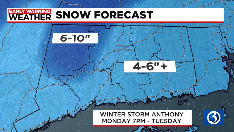
What does the "+" mean? I don't really get the open ended bounds or the feathering between contours. But that's just me lol
-
3
-
-
Euro looks like a scalping after some front end stuff in CT.
-
1
-
-
9 minutes ago, ORH_wxman said:
More snow tomorrow than 2/28?
Close to it lol
-
Hope everyone enjoys their flurries on the NAM.
-
2
-
-
Congrats Scooter on the GFS
-
Might as well lock in 12-24. Can go higher if needed.
When are we expecting Kevin to make the pivot to snow/cold?
-
4
-
-
Just now, brooklynwx99 said:
this is easily the best threat for CNE/SNE towards NYC that we've had all winter. not close
hopefully we can hold until it's within 4-5 days
Sure is.
-
4
-
-
Man.... Tuesday looks tasty.
-
2
-
-
2 minutes ago, Ginx snewx said:
I don't understand all the talk about the tuck. That's after all precip has ended. Don't know how impactful it is at all.
Looks like a prolonged period of freezing drizzle around here.
-
2
-
-
GFS has one heck of a cold tuck Thursday. Going to be icy.
-
2
-
Currently monitoring guidance for March late 3rd through the 4th for the next ( beyond the 28th) significant event
in New England
Posted
Meh.
I fly out tomorrow morning for Telluride so whatever.