

CT Rain
-
Posts
25,962 -
Joined
-
Last visited
Content Type
Profiles
Blogs
Forums
American Weather
Media Demo
Store
Gallery
Posts posted by CT Rain
-
-
Just now, Typhoon Tip said:
What's going on with NWS ?
I don't wanna be flippant or impugn but ...there's been like 7 day of antecedent consistency to pull a trigger on Headline graphics. The other office did, what's the hold up?
I needed those for critical update. Damn it
I was surprised to see no advisories this afternoon.
-
 2
2
-
-
Euro is definitely colder. Really odd battle here shaping up lol.
I do feel like it's different from the typical SWFE look where the globals are slow with the mid level warm layer compared to the mesos. This is just a very different synoptic-scale track of the mid and upper level features.
-
1
-
 1
1
-
-
1 hour ago, CoastalWx said:
Yeah I was comparing similar areas in the snow shield to get a thermal sense because taking the sounding at the same location is night and day between NAM and GFS,
Almost seems like it's more of a synoptic issue with the track of the mid level lows than a typical meso vs global kind of battle in a SWFE.
-
1 minute ago, TalcottWx said:
BOX is really taking a conservative approach
A coating-2" is a pretty reasonable call from them IMO.
-
2
-
-
18z GFS looks a bit juicier.
-
2 minutes ago, Sey-Mour Snow said:
Unfortunately places along the shore and valleys in southern CT look too warm for any accumulations which would go along with seasonal trends. The 75 day accumulating snowless drought for @The 4 Seasons looks to continue.
Could be one of those situations where it's relatively easy to cool to 32F if rates pick up enough.
-
1
-
-
1 minute ago, ORH_wxman said:
3k beefed up too from 12z.
Went coating-2" for most of CT but damn the 18z NAM run is impressive.
-
2
-
-
Put this together for the station's 70th anniversary. I thought some of you might get a kick out of the old video.
-
5
-
-
68F at BDR breaks the all-time February record set back in... no surprise... 2022.
-
1
-
 2
2
-
-
67F at BDR ties their all-time February record.
-
2
-
-
Kevin isn't handling this winter well

-
1
-
9
-
-
It would be classic 2022-2023 if we managed a giant ice storm and wound up with little snow lol
-
1
-
4
-
-
3 minutes ago, brooklynwx99 said:
it's going to be very difficult for storms to cut with deep negative anomalies over the 50/50 region. this would favor overrunning events and SWFEs that begin cold
even if they do "cut" you're likely to get snow on the front end anyway

Yeah it does look like the pattern will support cold and a nice anticyclone to the north thanks to confluence.
Even if we do "cut" should be a pretty classic SWFE kind of event.
-
3
-
 1
1
-
-
2 minutes ago, Damage In Tolland said:
We had a cold , stormy look on modeling for weeks beginning in mid- late Mowvember for December ..Ensembles, weeklies, op runs all were unanimous. And they were all wrong. So there is zero reason to buy in and not assume we will be bent over the rowboat with oars once again.
Meh. You'll be onboard by Monday. Will just have to listen to you whine between now and then.
-
2
-
7
-
-
It looks pretty good to me for a D8/9 threat. Not sure what all the hand wringing is about.
-
3
-
2
-
-
1 minute ago, CoastalWx said:
There is something refreshing about not exaggerating totals, no “in the hills, river east” etc.
The KFS was so traumatized by the halftime performance it's been shut down for a bit.
-
2
-
-
5 minutes ago, CoastalWx said:
No KFS incorporated?
When will KFS flip from warm to cold again?
-
2 minutes ago, CoastalWx said:
Yeah for once we have some consistency. Not that it means much this far out, but it’s something.
I thought about not including it because of the way this winter has been but it looked decent for a D9 event.
-
1
-
-
15 minutes ago, CoastalWx said:
1956 ain’t coming, but maybe we can get some action later next week.
I had a mix in the forecast for Day 9 and Day 10 in the 10-day forecast. It was crazy how long it had been since I've even had something like that pop up on the graphics.
-
2
-
-
5 minutes ago, ORH_wxman said:
That's kind of a ridiculous fronto band....too bad it's prob wrong.
Might be a scalping too based on the soundings.
-
1
-
-
37 minutes ago, CoastalWx said:
Hope to never see 1888 redux.
hahah I can't wait
-
1
-
-
Just now, ORH_wxman said:
Pre-1950 is kind of a wasteland for good snowstorm impacts…also doesn’t help that the 2-3 decades leading up to it were pretty horrible for snow.
How does Dec 19, 1945 rank in CT? I know it was a big storm for HFD but wasn’t sure about statewide impact. Usually a big dog in HFD is good for most of the state though.
The Hamden coop didn't have >10" from either December 1945 storm. Seems like Hartford really lucked out for those 2.
-
1 minute ago, ORH_wxman said:
Feb ‘83 was pretty huge in CT too.
Yeah February 83 is up there but falls short of 2013.
1888 & 1978 for sure and 2011 for a different reason.
Anything pre-1950?
-
13 minutes ago, JKEisMan said:
@CT Rain is KDXR asos reading accurately- everything else around is at or below zero. Seems there’s a sensor problem?
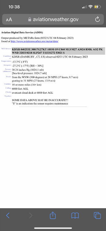
I see 0F in New Milford and 9F in Greenwich so 4F is reasonable there. There's definitely a gradient with the core of the cold over eastern New England and less the farther SW you go.

Very persistent signal for moderate snow and ice impact between "Wed night" and "Thur night" this week
in New England
Posted
HRRR looks a bit colder to me compared to 18z. Waiting for the NAM to come in as a furnace again lol.