CT Rain
-
Posts
26,257 -
Joined
-
Last visited
Content Type
Profiles
Blogs
Forums
American Weather
Media Demo
Store
Gallery
Everything posted by CT Rain
-

The last hurrah? Putting all the eggs in the Tuesday 3/14 basket
CT Rain replied to Ginx snewx's topic in New England
Eh?
-
The last hurrah? Putting all the eggs in the Tuesday 3/14 basket
CT Rain replied to Ginx snewx's topic in New England
It's funny that the clown map brigade is convinced 1-2 feet for most is a good bet. -
The last hurrah? Putting all the eggs in the Tuesday 3/14 basket
CT Rain replied to Ginx snewx's topic in New England
Beware the clown maps.
-
The last hurrah? Putting all the eggs in the Tuesday 3/14 basket
CT Rain replied to Ginx snewx's topic in New England
Just saw the GFS. Jesus. -
The last hurrah? Putting all the eggs in the Tuesday 3/14 basket
CT Rain replied to Ginx snewx's topic in New England
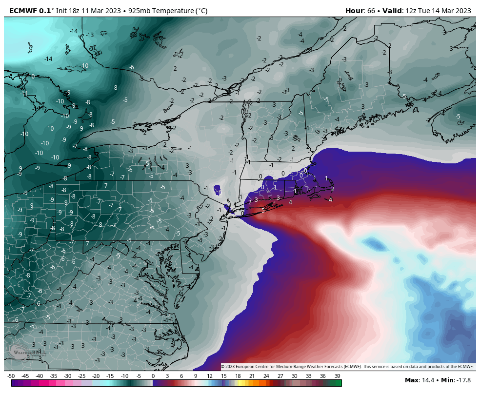
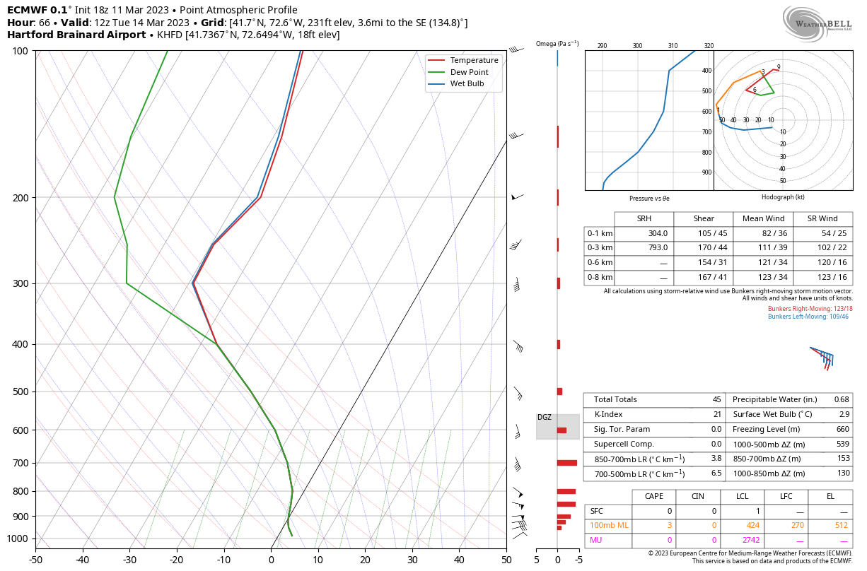
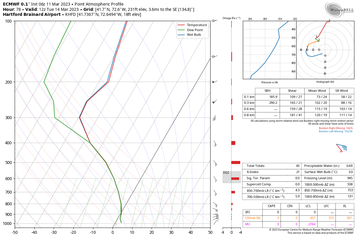
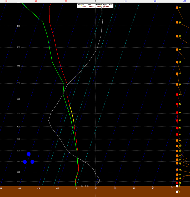
High res op run may be picking up on some cyclogenesis along the inverted trough a bit better than the coarser ensembles but it is nice to see things consolidate pretty quickly. The 12z Euro soundings were pretty warm here in the BL. Hopefully we can work on that a bit in later runs. -
The last hurrah? Putting all the eggs in the Tuesday 3/14 basket
CT Rain replied to Ginx snewx's topic in New England
That's a nice look on the EPS overall. Still worried about some warming initially here a bit farther south but can't complain much. -
The last hurrah? Putting all the eggs in the Tuesday 3/14 basket
CT Rain replied to Ginx snewx's topic in New England
Yeah I think the "dual low" thing isn't really worth tossing. It's just a reflection of surface pressure falls along the inverted trough prior to full phase/capture. So even if the low isn't as distinct in reality that E/SE flow ahead of the inverted trough will do some damage to the BL. -
The last hurrah? Putting all the eggs in the Tuesday 3/14 basket
CT Rain replied to Ginx snewx's topic in New England
lol you're not wrong. I do think that even the "good" looking tracks are going to have issues here in the valley with a pretty torched BL. Going to be a needle threader. Feel better for W CT though as it looks like the congrats ALB scenario is less likely. -
The last hurrah? Putting all the eggs in the Tuesday 3/14 basket
CT Rain replied to Ginx snewx's topic in New England
Well I'm not that certain. The Euro is still torched in the boundary layer and verbatim is a lot of rain out of the hills.
-
The last hurrah? Putting all the eggs in the Tuesday 3/14 basket
CT Rain replied to Ginx snewx's topic in New England
Starting to get more bullish here in CT. The tucked trend has slowed or even reversed. Not much cold air to work with but may be just enough given the very well timed bombing/occlusion to bring the heavy stuff here. -
The last hurrah? Putting all the eggs in the Tuesday 3/14 basket
CT Rain replied to Ginx snewx's topic in New England
How we pray. Jeez. -
The last hurrah? Putting all the eggs in the Tuesday 3/14 basket
CT Rain replied to Ginx snewx's topic in New England
Verbatim GFS is a deck destroyer here. Sure does thread the effing needle though. -
The last hurrah? Putting all the eggs in the Tuesday 3/14 basket
CT Rain replied to Ginx snewx's topic in New England
lol -
The last hurrah? Putting all the eggs in the Tuesday 3/14 basket
CT Rain replied to Ginx snewx's topic in New England
Those clown maps off the GFS are hilarious... especially considering the models cold bias and how the soundings look verbatim. -
The last hurrah? Putting all the eggs in the Tuesday 3/14 basket
CT Rain replied to Ginx snewx's topic in New England
Parachutes in West Hartford and rain in Tolland? Sign me up. -
The last hurrah? Putting all the eggs in the Tuesday 3/14 basket
CT Rain replied to Ginx snewx's topic in New England
The NAM has the "look" at H84 lol -
March 10-11 light snow threat for SW New England.
CT Rain replied to Sey-Mour Snow's topic in New England
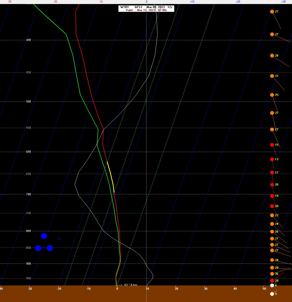
12km is very warm in the boundary layer. -
The last hurrah? Putting all the eggs in the Tuesday 3/14 basket
CT Rain replied to Ginx snewx's topic in New England
Selfishly I don't mind a somewhat earlier bombing south of Long Island. -
March 10-11 light snow threat for SW New England.
CT Rain replied to Sey-Mour Snow's topic in New England
You just texted 6-10" -
The last hurrah? Putting all the eggs in the Tuesday 3/14 basket
CT Rain replied to Ginx snewx's topic in New England
GFS is nice for many. Definitely a step toward the Euro. -
March 10-11 light snow threat for SW New England.
CT Rain replied to Sey-Mour Snow's topic in New England
Yeah could see some tree issues W CT and Hudson Valley too. -
March 10-11 light snow threat for SW New England.
CT Rain replied to Sey-Mour Snow's topic in New England
Friday night's event has a few things going for it. Upper level low is tracking a bit farther north and it dives right over NYC which is always interesting for areas just north. Also, the GFS is showing some impressive snow growth under the heavier band with max lift right around -15c. Wouldn't be surprised to see some 10 spots in SE NY or even SW CT.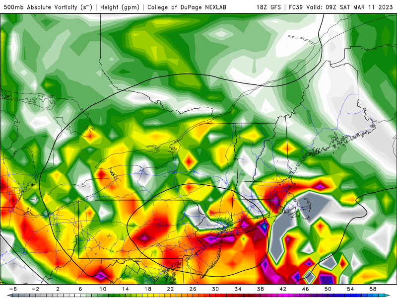
-
March 10-11 light snow threat for SW New England.
CT Rain replied to Sey-Mour Snow's topic in New England
NAM is now on board. Pretty impressive look now for W/SW CT with that H5 low track squeezing underneath. -
The last hurrah? Putting all the eggs in the Tuesday 3/14 basket
CT Rain replied to Ginx snewx's topic in New England
I'd be. Little cold around and nothing to prevent this from becoming a stemwinder over Kevin's fanny. -
The last hurrah? Putting all the eggs in the Tuesday 3/14 basket
CT Rain replied to Ginx snewx's topic in New England
Toaster bath