DeltaPilot
-
Posts
178 -
Joined
-
Last visited
Content Type
Profiles
Blogs
Forums
American Weather
Media Demo
Store
Gallery
Everything posted by DeltaPilot
-
IM a 757/767 Captain in ATL. Also own a forked tail Dr killer (V-tail Beechcraft Bonanza for the non aviation types) based at KFFC
-
Ill take one more north tick here. Whatever falls is going to immediately accumulate here for once.
-
Ill bet ya we get 1/4-1/2 inch suzook. What would you like to wager? Im just NE of downtown Senoia off Rockaway
-
Looks like the snow line is going to taper off right around ATL proper. I think north of that its a dusting to non accumulating flakes. South of the airport Looks like we have a chance at some accumulations right now, but its gonna be close. As I said earlier, Ill be happy with half an inch of white stuff, but hoping for 1". Still some time, and predicting where the "line" is right now, and even during the event, is pretty much impossible. I do think we will see widespread snow, but real accumulations will be south of KATL and where Im at in Senoia and more into Central and Southern GA. Earlier everything was trending south and Im still worried we just get some flakes here and no real accumulation, but most of the ensembles and the better models have held on to us south of ATL getting "something" accumulating. Fingers crossed. I think it only needs to be off by 30 miles or so for real differences to be seen.
-
Im not cliff diving yet. Im in the 1.5-2ish zone on the Euro. Ill even take a half an inch for the win. As some have said, if this verifies and the folks along the coast score more than a few inches that will be EPIC!!! I was in Jacksonville, FL for the Winter 89 event and it was crazy! I'll be happy for them. Remember that it aint over until the Fat Lady sings and I havent heard her warming up quite yet.
-
Just need the models to tick north a few miles and I’ll be happy. Most model runs/ensembles have seen us getting some measurable snow for the last 4-5 days. Would be awesome to see two events in one month. We got about 1.5 here last one(20nm S of KATL). Its pretty darn rare that S of ATL we might be on the NORTH side of a snow event!
-
 Looking at just over an inch. Im in Senoia just immediately S of KFFC. Sleet snow mix and just started light rain off and on and getting glaze. Im pretty happy!
 -
Im wishcasting about an .5-1 inch of pretty white stuff with some sleet and then little or no Ice. Anything at this point. Looks like down here in Peachtree City we are going to be right on the edge. Been a while here.
-
Is it time to break out the 11th event and the 14th event? Seems there might be a tad of confusion in here regarding the two different events. I keep seeing models posted for both. Sure looking like the second event has a bit more chances for accumulations here around ATL atm.
-
Rad, Probably some attenuation going on there. Storm needs to get closer to the radar.
-
CDO still looking like its struggling a bit. Doesnt have that symmetrical look quite yet, but it looks better than it has since early this am.
-
It sure is Allsnow. Been pouring off and on here since about 1130 am. Looks to go on for the rest of tonight and into tommorow, then we get the northern bands from Helene.
-
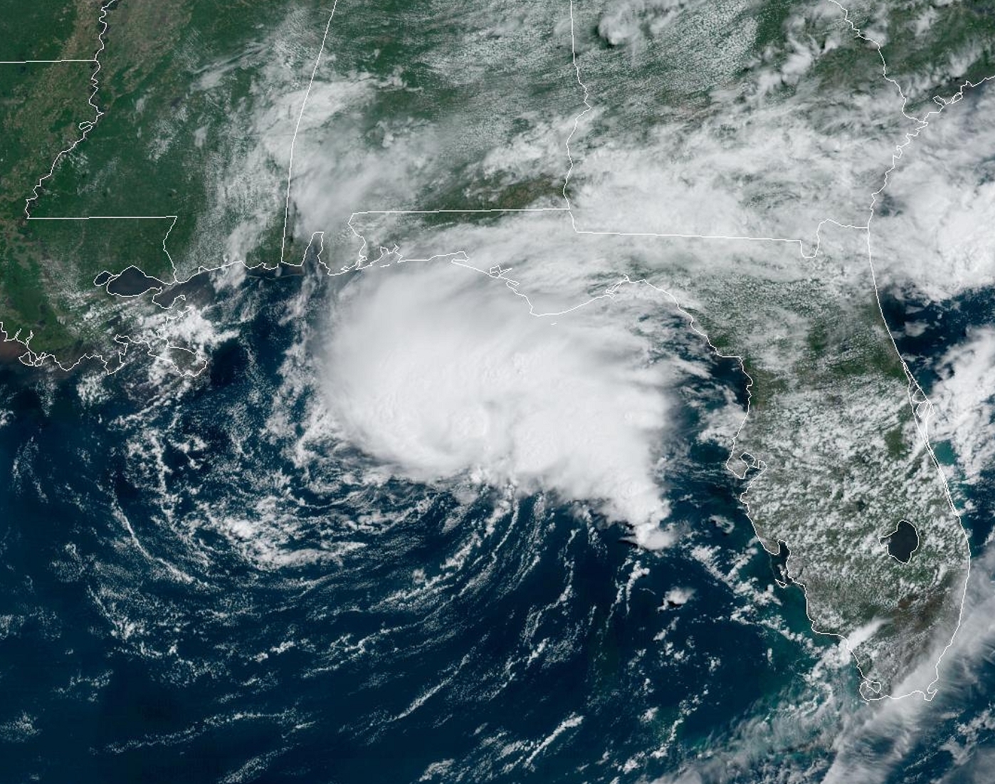
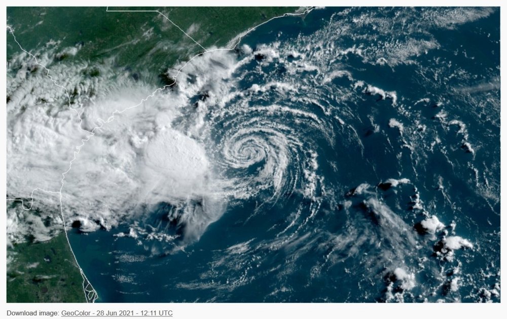
Looking at Satellite this am sure seems the convection is displaced quite a bit east and slightly south of the current center being depicted. Will be interesting to see what Recon finds.
-
Did the Hurricane Hunters fly this storm? Seeing a lot of "debate" about what this storm actually was Strength wise when it made landfall. It was obviously undergoing degradation from terrain, but Im curious. Hard to believe the lack of coverage for this event. Damage looks to support at least a high end CAT 3 and easily a 4 from what I have seen so far.
-
2023 Atlantic Hurricane season
DeltaPilot replied to Stormchaserchuck1's topic in Tropical Headquarters
Looking like its slightly better "organized". More convection this am. Looks displaced eastward from center, but NHC put it at 50% this am.
-
Anyone have any good links to damage assessment, videos etc for Ian around Ft Meyers?
-
Can I make a suggestion to anyone who will get to take videos of damage or whatever. SLOWDOWN PANNING YOUR DEVICE. DONT WALK WHILE FILMING. G E E Z U S.
-
Its pretty early to be wishcasting ERC's. Lets see what happens once it emerges off the Cuban coast in the morning. The really tough call on this is the trough strength and the fact that 10 or 20 miles one way or the other may make a LOT of difference if it scrapes along the coast all day as it nears landfall or closest approach. This thing does not need to make landfall to cause historic flooding and surge damage.
-
2022 Atlantic Hurricane season
DeltaPilot replied to StormchaserChuck!'s topic in Tropical Headquarters
Noticed that swirl off the SC/GA coast on the Sat imagery this am. More returns now associated with it. -
Winter Storm Izzy Obs Thread
DeltaPilot replied to Prismshine Productions's topic in Southeastern States
35 here in Senoia, GA and a few flakes mixed in with the drizzle. Dont think the cold air is gonna make it here for any real accumulation. Was hoping for a dusting, but not holding my breath. -
Just...WOW...... https://twitter.com/T_Hofelich/status/1469525957941895173?s=20&fbclid=IwAR1aEYFbSNNPqnByG_XENgIiB_QDRrDvZP9K29JfG5t4Pa0gGasyxryUWko
-
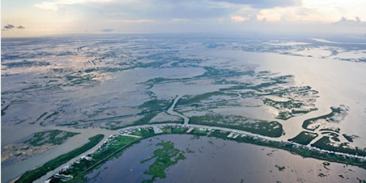
For folks wondering how a Hurricane can retain a lot of energy over the Mississippi Delta, here is a shot of what most of it looks like south of Morgan City, Houma and out towards Grand Isle and east. Its mostly water and it isnt any cooler than the GOM is. Will take a while until its over more "dry" land to spin down. A lot of energy to tap there. Not like the Ocean, but far better than dry land.

-
Maybe what I meant is "stacking". Definitely needs some larger convection to fire around that swirl.
-
It's definitely got some Organizing to do and not a lot of time to do it. We....GA...do NOT need the rain!!!!
-
The updated NWS radar is terrible
DeltaPilot replied to Heisy's topic in Weather Forecasting and Discussion
The last real "free" place with a semi decent Radar picture turned into CRAP! Sending a strongly worded email asap.