

yoda
-
Posts
62,942 -
Joined
Content Type
Profiles
Blogs
Forums
American Weather
Media Demo
Store
Gallery
Everything posted by yoda
-
@MN Transplant guess this was just north of you? Emergency management and NWS employees report half dollar size hail in Falls Church per LSR
-
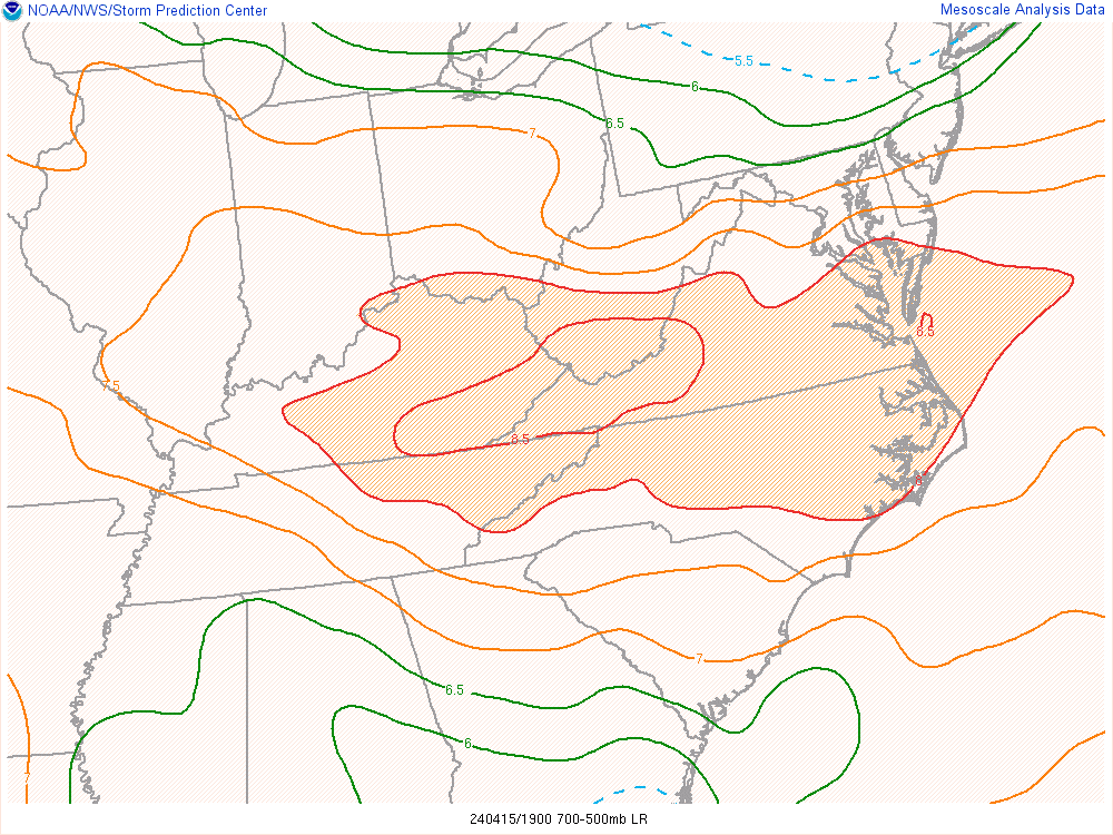
Don't see this either everyday in our region - 3pm mid-level lapse rates
- 1,696 replies
-
- 1
-

-
- severe
- thunderstorms
- (and 5 more)
-
Warrenton cell just went severe
-
Looks like the Fairfax cell is dragging an outflow boundary behind it/to its west on Radarscope?
- 1,696 replies
-
- 1
-
-
- severe
- thunderstorms
- (and 5 more)
-
Area Forecast Discussion National Weather Service Baltimore MD/Washington DC 229 PM EDT Mon Apr 15 2024 .SYNOPSIS... A cold front will drop southward through the area tonight, before returning northward as a warm front on Wednesday. A strong cold front will move through this weekend, with high pressure building in early next week. && .NEAR TERM /THROUGH TONIGHT/... Severe Thunderstorrm Watch #109 is valid until 10 PM since it covers most of VA to the NC border, although storms are likely to exit our forecast around 7 PM. Very steep mid-level lapse rates of around 8C/km due to 500 mb temps of around -20C were observed on earlier upper air data and more recent MetOp-C NUCAPS data. This will contribute to a very favorable environment for large hail perhaps approaching significant hail up to 2 inches in diameter. Storms will be fast movers moving around 35 knots and given large dewpoint depressions and strond mid-level flow may be also capable of producing strong to damaging winds. Storms should exit our CWA by 8 PM, likely a little sooner than that. Rapidly clearing skies are expected later this evening behind exiting cold front. High pressure builds over the area overnight into Tue morning with quiet conditions overnight through Tue morning.
- 1,696 replies
-
- 1
-
-
- severe
- thunderstorms
- (and 5 more)
-
Coming for @MN Transplant BULLETIN - IMMEDIATE BROADCAST REQUESTED Severe Thunderstorm Warning National Weather Service Baltimore MD/Washington DC 259 PM EDT Mon Apr 15 2024 The National Weather Service in Sterling Virginia has issued a * Severe Thunderstorm Warning for... The southwestern District of Columbia... Arlington County in northern Virginia... The City of Falls Church in northern Virginia... Northeastern Fairfax County in northern Virginia... The City of Alexandria in northern Virginia... * Until 345 PM EDT. * At 258 PM EDT, a severe thunderstorm was located over Reston, moving east at 30 mph. HAZARD...Quarter size hail. SOURCE...Trained weather spotters. IMPACT...Some hail damage to agriculture is expected. * Locations impacted include... Arlington, Alexandria, Reston, Annandale, Vienna, Falls Church, Pimmit Hills, Reagan National Airport, Mclean, Rosslyn, Crystal City, Howard University, Oakton, Lincolnia, Tysons Corner, Wolf Trap, Merrifield, Lake Barcroft, American University, and I66 and I495 Interchange. PRECAUTIONARY/PREPAREDNESS ACTIONS... For your protection move to an interior room on the lowest floor of a building.
-
Severe Weather Statement National Weather Service Baltimore MD/Washington DC 242 PM EDT Mon Apr 15 2024 VAC059-107-151900- /O.CON.KLWX.SV.W.0015.000000T0000Z-240415T1900Z/ Loudoun VA-Fairfax VA- 242 PM EDT Mon Apr 15 2024 ...A SEVERE THUNDERSTORM WARNING REMAINS IN EFFECT UNTIL 300 PM EDT FOR SOUTHEASTERN LOUDOUN AND NORTHWESTERN FAIRFAX COUNTIES... At 242 PM EDT, a severe thunderstorm was located over Brambleton, moving east at 35 mph. HAZARD...Golf ball size hail reprted by a trained spotter in Hanson Park. SOURCE...Trained weather spotters. IMPACT...Hail is large enough to dent and damage vehicles. Some damage to roofs, siding, and windows is possible. Locations impacted include... Reston, Herndon, Fairfax, Broadlands, Brambleton, Dulles International Airport, Ashburn, Oakton, Sterling, Wolf Trap, Great Falls, and Arcola. PRECAUTIONARY/PREPAREDNESS ACTIONS... For your protection move to an interior room on the lowest floor of a building. && LAT...LON 3898 7726 3886 7731 3887 7733 3897 7758 3902 7756 TIME...MOT...LOC 1842Z 287DEG 29KT 3897 7750 THUNDERSTORM DAMAGE THREAT...CONSIDERABLE HAIL THREAT...RADAR INDICATED MAX HAIL SIZE...1.75 IN WIND THREAT...RADAR INDICATED MAX WIND GUST...<50 MPH
-
Trained spotters reported goofball size hail in Hanson Park - that's the Fairfax/Loudoun warned cell
-
Severe Weather Statement National Weather Service Baltimore MD/Washington DC 224 PM EDT Mon Apr 15 2024 MDC031-151845- /O.CON.KLWX.SV.W.0014.000000T0000Z-240415T1845Z/ Montgomery MD- 224 PM EDT Mon Apr 15 2024 ...A SEVERE THUNDERSTORM WARNING REMAINS IN EFFECT UNTIL 245 PM EDT FOR CENTRAL MONTGOMERY COUNTY... At 224 PM EDT, a severe thunderstorm was located over Gaithersburg, moving east at 35 mph. HAZARD...Ping pong ball size hail and 60 mph wind gusts. SOURCE...Radar indicated. IMPACT...Damaging winds will cause some trees and large branches to fall. This could injure those outdoors, as well as damage homes and vehicles. Roadways may become blocked by downed trees. Localized power outages are possible. Unsecured light objects may become projectiles. Locations impacted include... Germantown, Rockville, Bethesda, Gaithersburg, Olney, Aspen Hill, Potomac, North Bethesda, Montgomery Village, North Potomac, Redland, Chevy Chase, North Kensington, South Kensington, Rossmoor, Wheaton-Glenmont, Wheaton, Cloverly, Glenmont, and Darnestown. PRECAUTIONARY/PREPAREDNESS ACTIONS... For your protection move to an interior room on the lowest floor of a building. && LAT...LON 3915 7702 3900 7708 3912 7735 3917 7732 TIME...MOT...LOC 1824Z 289DEG 30KT 3913 7726 HAIL THREAT...RADAR INDICATED MAX HAIL SIZE...1.50 IN WIND THREAT...RADAR INDICATED MAX WIND GUST...60 MPH
-
Preliminary Local Storm Report National Weather Service Baltimore MD/Washington DC 210 PM EDT Mon Apr 15 2024 ..TIME... ...EVENT... ...CITY LOCATION... ...LAT.LON... ..DATE... ....MAG.... ..COUNTY LOCATION..ST.. ...SOURCE.... ..REMARKS.. 0159 PM Hail 3 S Lucketts 39.18N 77.54W 04/15/2024 M1.00 inch Loudoun VA Trained Spotter && Event Number LWX2403036
-
Poolesville cell looks nasty... see 70+ dbz on Radarscope
-
Looks like they added Baltimore metro
- 1,696 replies
-
- 2
-
-
- severe
- thunderstorms
- (and 5 more)
-
URGENT - IMMEDIATE BROADCAST REQUESTED Severe Thunderstorm Watch Number 109 NWS Storm Prediction Center Norman OK 150 PM EDT Mon Apr 15 2024 The NWS Storm Prediction Center has issued a * Severe Thunderstorm Watch for portions of District Of Columbia Southern Delaware Central and Eastern Maryland Virginia Central and Eastern West Virginia Coastal Waters * Effective this Monday afternoon and evening from 150 PM until 1000 PM EDT. * Primary threats include... Scattered damaging wind gusts to 70 mph likely Scattered large hail and isolated very large hail events to 2 inches in diameter possible SUMMARY...Broken bands of strong to severe thunderstorms are forecast to develop this afternoon and move east-southeast through the mid evening. Scattered severe gusts capable of wind damage will be possible with the stronger cores and outflow winds. Large hail may accompany the early cellular storm activity. The severe thunderstorm watch area is approximately along and 90 statute miles north and south of a line from 20 miles west northwest of Beckley WV to 30 miles east southeast of Wallops VA. For a complete depiction of the watch see the associated watch outline update (WOUS64 KWNS WOU9).
-
Severe warned storm by Berryville should be near DC metro by 3 Is that a hook up by Waterford?
-
Warnings issued for both cells
-
Mesoscale Discussion 0439 NWS Storm Prediction Center Norman OK 1203 PM CDT Mon Apr 15 2024 Areas affected...portions of West Virginia...Virginia...Maryland...and Delaware Concerning...Severe potential...Severe Thunderstorm Watch likely Valid 151703Z - 151900Z Probability of Watch Issuance...95 percent SUMMARY...Thunderstorm activity is expected to increase by 3-4pm EDT. Damaging gusts to 60-70 mph and large hail to 1.5 inches in diameter will be possible through early evening. DISCUSSION...Gradual destabilization is occurring from west to east early this afternoon across the MCD region. Increasing cumulus development is noted over the past hour across the higher terrain of West Virginia into northern Virginia as temperatures have warmed into the 70s to low 80s. The 12z MPAS-HT high-res guidance appears to have the best handle on morning convection across the region, and in the expected convective evolution through early evening. Based on this guidance, and current observed trends, thunderstorm activity is expected to increase by 19-20z/3-4pm EDT near/south of a residual frontal boundary draped west to east across the region. This development will be aided by continued heating/destabilization, increasing midlevel moisture and a very steep low and midlevel lapse rate environment (midlevel lapse rates around 8 C/km with southward extent across VA). While low-level winds will remain light, a belt of 30-40 kt midlevel flow will foster effective shear magnitudes suitable for organized convection. Initial cellular activity will pose a risk for large hail and strong gusts. Meanwhile, a deeply mixed boundary-layer with inverted-v sub-cloud thermodynamic profiles suggest strong outflow winds will occur with this activity and clustering is likely to occur via outflow interactions. A damaging wind threat will increase with southeastward extent across Virginia toward the Chesapeake Bay vicinity where steep low-level lapse rates and DCAPE over 1000 J/kg will be focused. A severe thunderstorm watch will likely be needed for portions of the MCD vicinity by 18-19z. ..Leitman/Smith.. 04/15/2024 ...Please see www.spc.noaa.gov for graphic product... ATTN...WFO...PHI...AKQ...LWX...RNK...PBZ...RLX...
- 1,696 replies
-
- 1
-
-
- severe
- thunderstorms
- (and 5 more)
-
Severe Thunderstorm Watch coming soon per SPC MCD
-
Storms entering NW VA increasing in intensity and some hail cores slowly starting to appear
-
1630z disco .Lower OH Valley into the Mid-Atlantic states... Morning surface mesoanalysis places a residual frontal zone draped over central IN/OH with a low-level moisture reservoir (low 60s deg F surface dewpoints) extending from the confluence of the MS/OH rivers northeastward into the lower Wabash Valley. Atop this moisture, a plume of steep 700-500 mb lapse rates (8.0 to 8.3 deg C/km) sampled at the Lincoln, IL and Wilmington, OH raob sites, will overspread the OH Valley eastward into VA today. The richer low-level moisture will likely remain west of the Appalachians across the lower OH Valley where 1500-2500 J/kg MLCAPE is forecast. Widely scattered thunderstorms are forecast to develop by mid afternoon within the moist axis along/south of a stalled front over the OH Valley. Effective shear 25-35 kt will support a mix of supercells and organized line segments capable of hail and wind. Farther east, steep lapse rates from the surface to 500 mb are depicted in forecast soundings by early to mid afternoon (8 deg C/km). Although PW will be lower across the Mid-Atlantic region, a more deeply mixed boundary layer is forecast with strong westerly mid-level flow (40 kt). Initial cellular storms will likely develop over the higher terrain with subsequent development across northern VA. A band of storms posing a risk for severe gusts (60-70 mph) and resultant wind damage is forecast. Given the lapse rate profile coupled with ample mid- to high-level flow and a linear mode, have increased wind probabilities and an upgrade to level 3 categorical outlook this update. The overall severe threat should gradually diminish through late evening with the loss of diurnal heating.
- 1,696 replies
-
- 1
-
-
- severe
- thunderstorms
- (and 5 more)
-
Yup And added ENH to our south including EZF into S MD
-
Wonder if the 1630z OTLK will pull the SLGT risk a bit further north and west
-
Mesoscale Discussion 0438 NWS Storm Prediction Center Norman OK 1001 AM CDT Mon Apr 15 2024 Areas affected...portions of eastern West Virginia...northern Virginia and western Maryland Concerning...Severe potential...Watch unlikely Valid 151501Z - 151630Z Probability of Watch Issuance...5 percent SUMMARY...Isolated showers and thunderstorms may produce gusty winds or small hail the next couple of hours across parts of the West Virginia, Maryland and Virginia border vicinity. DISCUSSION...A couple of thunderstorms have developed late this morning ahead of a stationary boundary near the WV/MD/VA border. This activity is likely somewhat elevated. Nevertheless, weak instability (generally less than 500 J/kg MUCAPE) amid steep midlevel lapse rates and modest effective shear could support sporadic small hail. A dry, mixed boundary-layer and light low-level flow also may foster gusty winds around 40-50 mph. This initial thunderstorm activity is expected to remain isolated and the overall severe threat limited over the next couple of hours, and a watch is not expected. The severe threat will increase across portions of Mid-Atlantic later this afternoon, and this later threat will be addressed with additional MCDs in the coming hours. ..Leitman/Smith.. 04/15/2024 ...Please see www.spc.noaa.gov for graphic product... ATTN...WFO...LWX...PBZ...RLX...
-
Area Forecast Discussion...UPDATED National Weather Service Baltimore MD/Washington DC 910 AM EDT Mon Apr 15 2024 .SYNOPSIS... A cold front will drop southward through the area tonight, before returning northward as a warm front on Wednesday. A strong cold front will move through this weekend, with high pressure building in early next week. && .NEAR TERM /THROUGH TONIGHT/... Model trends past 24 hrs have shown storms this afternoon developing further north than anticipated yesterday roughly now from along and south of the US-50 corridor or south of I-70 along a lee-side trof. New 13Z SPC DY1 Otlk has shifted the Slight risk further north into areas south of the Capital Beltway. Hail is expected to be the primary threat given 7.3 C/km mid-level lapse rates and decent CAPE above -20C seen on the 12Z IAD sounding. Storms would also be relatively fast movers with 0-6 km mean winds of 28kt posing a marginal damaging wind threat.
- 1,696 replies
-
- 1
-
-
- severe
- thunderstorms
- (and 5 more)
-
SLGT risk pushed north to DC metro... MRGL to near Mason-Dixon line on 1300z SPC OTLK
-
Hmmm... later today surprise? NEAR TERM /THROUGH TONIGHT/... Showers and a few thunderstorms continue to slowly drift southeastward across the northern half of the forecast area early this morning. This remnant activity should continue to weaken over the coming hours, and eventually dissipate prior to daybreak. Clouds associated with this activity may linger for the first half of the morning, but clearing and ample sunshine is expected during the second half of the morning into the early afternoon. A diffuse cold front will continue to slowly drift southward across the forecast area today. Daytime heating will allow instability to build, with around 1000 J/kg of CAPE present by peak heating this afternoon. Additional thunderstorms are expected to develop within the zone of low-level convergence near the surface front later this afternoon. There`s some uncertainty as to where exactly this will occur. Any location in the forecast area has at least a slight chance for a thunderstorm, but the greatest chance should generally be south of I-66/US-50 and east of US-15. Further west, westerly flow and downsloping will act to further dry out an already dry boundary layer, which should limit storm coverage as a result. Further north, they`ll likely end up to the north of the best- low-level convergence, which should also limit the coverage of storms. Where storms do form, they`ll likely be strong to severe. Model soundings show an environment that is more typical of the High Plains than the Mid-Atlantic. Boundary layer moisture will be rather limited, with dewpoints only in the 50s, but lapse rates will be very steep (dry adiabatic in the lowest three kilometers, with mid- level lapse rates around 7.5-8 C/km). Flow will be relatively weak in the boundary layer, but pick up rapidly in the mid- levels, with continued shear through the upper levels. Hodographs are relatively straight, so storm splits may be possible, with both multicells and right/left moving supercells. Model soundings check a lot of boxes in recent research for hail producing storms. That may be the primary threat this afternoon, although the steep lapse rates and DCAPE values around 1000 J/kg should make damaging winds a threat as well. Tornadoes aren`t expected with a dry boundary layer and little to no low- level shear in place. The I-95 corridor south of DC to southern Maryland should stand the greatest chance of seeing a severe stoms. These storms will progress off to the south and east this evening, leading to dry conditions overnight.
- 1,696 replies
-
- 3
-
-

-
- severe
- thunderstorms
- (and 5 more)
