yoda
-
Posts
62,929 -
Joined
Content Type
Profiles
Blogs
Forums
American Weather
Media Demo
Store
Gallery
Everything posted by yoda
-
Mesoscale Discussion 1529 NWS Storm Prediction Center Norman OK 1048 AM CDT Tue Jul 01 2025 Areas affected...the Mid-Atlantic States Concerning...Severe potential...Severe Thunderstorm Watch likely Valid 011548Z - 011745Z Probability of Watch Issuance...95 percent SUMMARY...An increasing damaging wind threat and Severe Thunderstorm Watch issuance are expected this afternoon DISCUSSION...Convection has been slowly building across the central Appalachians, ahead of a low-amplitude shortwave trough that is progressing east across the Upper OH Valley. While there is some near-term uncertainty of how quickly this initial activity will strengthen amid weak DCAPE, the downstream airmass east of the Blue Ridge is destabilizing well as surface temperatures have already warmed into the upper 80s to low 90s. This will yield an uptick in convective intensity as clusters impinge on the Piedmont to Coastal Plain where mid 70s surface dew points are pervasive. Although lower-level winds will remain weak and predominately veered, moderate mid to upper-level westerlies will support organized multicells capable of producing multiple strong to isolated severe gust swaths. Scattered damaging winds appear likely towards mid to late afternoon. ..Grams/Mosier.. 07/01/2025 ...Please see www.spc.noaa.gov for graphic product... ATTN...WFO...PHI...AKQ...CTP...LWX... LAT...LON 40117372 39117452 37967617 37757901 38627929 40127907 40667848 40497568 40117372 MOST PROBABLE PEAK WIND GUST...55-70 MPH
-
Watch coming soon per MCD https://www.spc.noaa.gov/products/md/md1529.html
-
Hope you had a great birthday @mappy Sorry I'm late, I'm in England right now
-
A SLGT risk appears for this afternoon
- 1,378 replies
-
- 1
-

-
- severe
- thunderstorms
- (and 2 more)
-
Would be kind of ironic if today we reached 100 degrees
-
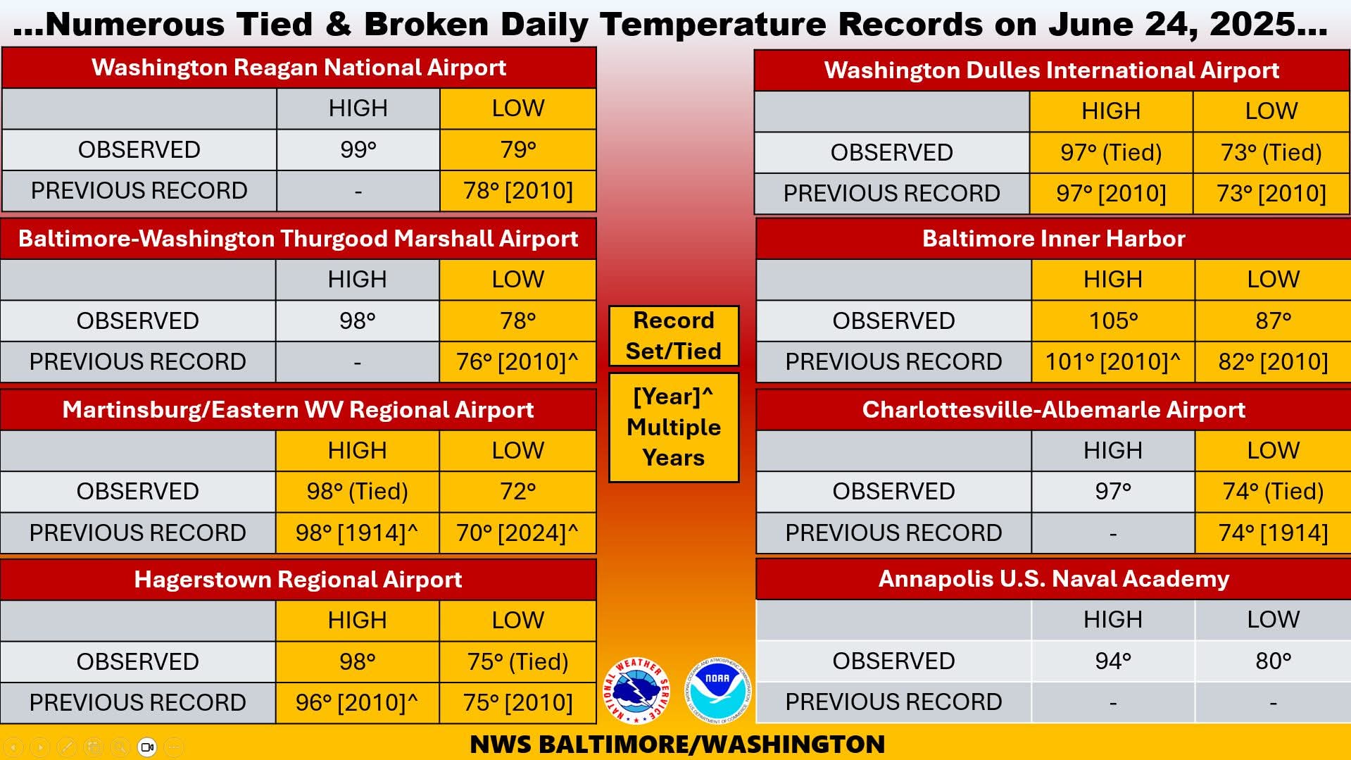
96 now at DCA... so got about 4 more hours to reach 100
-
FWIW, JFK is at 102
-
12pm DCA 95 BWI 95 IAD 93 Baltimore Inner Harbor and Patuxent are at 100
-
11am DCA 93 BWI 94 IAD 91
-
PNSLWX DCZ001-MDZ003>006-008-011-013-014-016>018-501>510-VAZ025>031- 036>040-050-051-053>057-501>508-526-527-WVZ050>053-055-501>506- 240045- Public Information Statement National Weather Service Baltimore MD/Washington DC 1242 PM EDT Mon Jun 23 2025 ...NWS Damage Survey for 06/18/25 Tornado Event... .Odenton MD Tornado... Rating: EF-0 Estimated Peak Wind: 80 mph Path Length /statute/: 0.1 miles Path Width /maximum/: 75 yards Fatalities: 0 Injuries: 0 Start Date: Jun 18 2025 Start Time: 2:15 PM EDT Start Location: Odenton / Anne Arundel County / MD Start Lat/Lon: 39.059 / -76.701 End Date: Jun 18 2025 End Time: 2:16 PM EDT End Location: Odenton / Anne Arundel County / MD End Lat/Lon: 39.057 / -76.700 Survey Summary: During the early afternoon of Wednesday June 18th, a cluster of severe thunderstorms crossed central Maryland between Washington and Baltimore. One storm briefly produced a tornado in northwestern Anne Arundel County Maryland, in southern Odenton. At 2:15 PM EST, a tornado touched down in the community of Chapel Village, just south of the southern end of Chapel Hill Blvd. There, along the north edge of a water retention pond, it uprooted two trees. It continued southeast and crossed the 800 block of Sunny Chapel Road. Here is where the damage was most intense. Three homes had siding and shingle damage. Behind one of the homes, numerous trees were uprooted and large sections of trees snapped. At least two trees fell onto homes, and one crushed an outdoor deck. Damage on the north side of the path was blown to the south, and damage on the south side of the path was blown to the north-northeast. The tornado proceeded southeast, and crossed the southern cul-de-sac of Golden Chapel Road. There it damaged shingles and siding on three additional homes, blew out the attic window on two homes, and uprooted three more trees and snapped large branches. At this point, after just a minute on the ground and a tenth of a mile path, the tornado lifted at 2:16 PM EDT. A funnel cloud video was shared on social media from Odenton. The ground survey continued to the southeast, but only isolated tree damage was seen sporadically, likely due to the severe thunderstorm wind gusts at times from the parent thunderstorm. The National Weather Service extends its appreciation to the Anne Arundel County Office of Emergency Management and our SKYWARN weather spotters who passed us damage information to supplement our ground survey. && EF Scale: The Enhanced Fujita Scale classifies tornadoes into the following categories: EF0.........65 to 85 mph EF1.........86 to 110 mph EF2.........111 to 135 mph EF3.........136 to 165 mph EF4.........166 to 200 mph EF5.........>200 mph
- 1,378 replies
-
- 5
-

-
- severe
- thunderstorms
- (and 2 more)
-
Going to be close... but I don't think we reach 100 at the 3 airports today looking at the 1pm obs 95 at DCA, 93 at IAD, 94 at BWI
-
11am obs DCA 92 IAD 90 BWI 92 Inner Harbor 98 Patuxent River is 98/74/109
-
URGENT - WEATHER MESSAGE National Weather Service Baltimore MD/Washington DC 937 AM EDT Mon Jun 23 2025 DCZ001-MDZ004>006-008-011-013-014-016>018-503>508-VAZ053>057-502-505- 506-526-527-232145- /O.UPG.KLWX.XH.A.0002.250624T1500Z-250625T0100Z/ /O.NEW.KLWX.XH.W.0002.250624T1500Z-250625T0100Z/ /O.CON.KLWX.XH.W.0001.250623T1500Z-250624T0100Z/ District of Columbia-Frederick MD-Carroll-Northern Baltimore- Cecil-Southern Baltimore-Prince Georges-Anne Arundel-Charles-St. Marys-Calvert-Northwest Montgomery-Central and Southeast Montgomery-Northwest Howard-Central and Southeast Howard- Northwest Harford-Southeast Harford-Fairfax-Arlington/Falls Church/Alexandria-Stafford-Spotsylvania-King George-Southern Fauquier-Western Loudoun-Eastern Loudoun-Northwest Prince William- Central and Southeast Prince William/Manassas/Manassas Park- 937 AM EDT Mon Jun 23 2025 ...EXTREME HEAT WARNING REMAINS IN EFFECT UNTIL 9 PM EDT THIS EVENING... ...EXTREME HEAT WARNING IN EFFECT FROM 11 AM TO 9 PM EDT TUESDAY... * WHAT...For the first Extreme Heat Warning, dangerously hot conditions with heat index values up to 110 expected. For the second Extreme Heat Warning, dangerously hot conditions with heat index values up to 110 expected. * WHERE...Portions of DC, central, north central, northeast, northern, and southern Maryland, and central and northern Virginia. * WHEN...For the first Extreme Heat Warning, until 9 PM EDT this evening. For the second Extreme Heat Warning, from 11 AM to 9 PM EDT Tuesday. * IMPACTS...Heat related illnesses increase significantly during extreme heat and high humidity events. PRECAUTIONARY/PREPAREDNESS ACTIONS... Drink plenty of fluids, stay in an air-conditioned room, stay out of the sun, and check up on relatives and neighbors. Do not leave young children and pets in unattended vehicles. Car interiors will reach lethal temperatures in a matter of minutes.
-
9am DCA 84 IAD 86 BWI 88 Inner Harbor/Science Center is 93 lol
-
KDMH - I think that's Baltimore Inner Harbor - was at 90 for its 8am ob
-
100 watch 8am temps DCA 81 IAD 82 BWI 85
-
URGENT - WEATHER MESSAGE National Weather Service Baltimore MD/Washington DC 221 PM EDT Sun Jun 22 2025 MDZ004-503-VAZ505-506-230230- /O.UPG.KLWX.XH.A.0001.250623T1500Z-250624T0100Z/ /O.NEW.KLWX.XH.W.0001.250623T1500Z-250624T0100Z/ /O.NEW.KLWX.XH.A.0002.250624T1500Z-250625T0100Z/ /O.CON.KLWX.HT.Y.0001.000000T0000Z-250623T0000Z/ Frederick MD-Northwest Montgomery-Western Loudoun-Eastern Loudoun- 221 PM EDT Sun Jun 22 2025 ...HEAT ADVISORY REMAINS IN EFFECT UNTIL 8 PM EDT THIS EVENING... ...EXTREME HEAT WARNING IN EFFECT FROM 11 AM TO 9 PM EDT MONDAY... ...EXTREME HEAT WATCH IN EFFECT FROM TUESDAY MORNING THROUGH TUESDAY EVENING... * WHAT...For the Heat Advisory, heat index values up to 107. For the Extreme Heat Warning, dangerously hot conditions with heat index values up to 110 expected. For the Extreme Heat Watch, dangerously hot conditions with heat index values up to 110 possible. * WHERE...In Maryland, Northwest Montgomery and Frederick Counties. In Virginia, Loudoun County. * WHEN...For the Heat Advisory, until 8 PM EDT this evening. For the Extreme Heat Warning, from 11 AM to 9 PM EDT Monday. For the Extreme Heat Watch, from Tuesday morning through Tuesday evening. * IMPACTS...Heat related illnesses increase significantly during extreme heat and high humidity events. Hot temperatures and high humidity may cause heat illnesses.
-
URGENT - WEATHER MESSAGE National Weather Service Baltimore MD/Washington DC 221 PM EDT Sun Jun 22 2025 MDZ003-VAZ027>031-WVZ052-053-230230- /O.UPG.KLWX.XH.A.0001.250623T1500Z-250624T0100Z/ /O.NEW.KLWX.XH.W.0001.250623T1500Z-250624T0100Z/ /O.NEW.KLWX.XH.A.0002.250624T1500Z-250625T0100Z/ /O.CON.KLWX.HT.Y.0001.000000T0000Z-250623T0000Z/ Washington-Shenandoah-Frederick VA-Page-Warren-Clarke-Berkeley- Jefferson- 221 PM EDT Sun Jun 22 2025 ...HEAT ADVISORY REMAINS IN EFFECT UNTIL 8 PM EDT THIS EVENING... ...EXTREME HEAT WARNING IN EFFECT FROM 11 AM TO 9 PM EDT MONDAY... ...EXTREME HEAT WATCH IN EFFECT FROM TUESDAY MORNING THROUGH TUESDAY EVENING... * WHAT...For the Heat Advisory, heat index values up to 104. For the Extreme Heat Warning, dangerously hot conditions with heat index values up to 107 expected. For the Extreme Heat Watch, dangerously hot conditions with heat index values up to 107 possible. * WHERE...In Maryland, Washington County. In Virginia, Clarke, Frederick, Page, Shenandoah, and Warren Counties. In West Virginia, Berkeley and Jefferson Counties. * WHEN...For the Heat Advisory, until 8 PM EDT this evening. For the Extreme Heat Warning, from 11 AM to 9 PM EDT Monday. For the Extreme Heat Watch, from Tuesday morning through Tuesday evening. * IMPACTS...Heat related illnesses increase significantly during extreme heat and high humidity events. Hot temperatures and high humidity may cause heat illnesses.
-
URGENT - WEATHER MESSAGE National Weather Service Baltimore MD/Washington DC 221 PM EDT Sun Jun 22 2025 DCZ001-MDZ005-006-008-011-013-014-016-504>508-VAZ053>055-502-526-527- 230230- /O.UPG.KLWX.XH.A.0001.250623T1500Z-250624T0100Z/ /O.NEW.KLWX.XH.W.0001.250623T1500Z-250624T0100Z/ /O.NEW.KLWX.XH.A.0002.250624T1500Z-250625T0100Z/ District of Columbia-Carroll-Northern Baltimore-Cecil-Southern Baltimore-Prince Georges-Anne Arundel-Charles-Central and Southeast Montgomery-Northwest Howard-Central and Southeast Howard-Northwest Harford-Southeast Harford-Fairfax- Arlington/Falls Church/Alexandria-Stafford-Southern Fauquier- Northwest Prince William-Central and Southeast Prince William/Manassas/Manassas Park- 221 PM EDT Sun Jun 22 2025 ...EXTREME HEAT WARNING IN EFFECT FROM 11 AM TO 9 PM EDT MONDAY... ...EXTREME HEAT WATCH IN EFFECT FROM TUESDAY MORNING THROUGH TUESDAY EVENING... * WHAT...For the Extreme Heat Warning, dangerously hot conditions with heat index values up to 110 expected. For the Extreme Heat Watch, dangerously hot conditions with heat index values up to 110 possible. * WHERE...Washington DC, and portions of central and northern Maryland, and northern Virginia. * WHEN...For the Extreme Heat Warning, from 11 AM to 9 PM EDT Monday. For the Extreme Heat Watch, from Tuesday morning through Tuesday evening. * IMPACTS...Heat related illnesses increase significantly during extreme heat and high humidity events. PRECAUTIONARY/PREPAREDNESS ACTIONS... Drink plenty of fluids, stay in an air-conditioned room, stay out of the sun, and check up on relatives and neighbors. Do not leave young children and pets in unattended vehicles. Car interiors will reach lethal temperatures in a matter of minutes.
-
Extreme Heat Warning for tomorrow... Extreme Heat Watch issued for Tuesday
-
LWX ZFP now calling for 101/102/100 next 3 days in DC metro
-
Preliminary Local Storm Report...Corrected National Weather Service Baltimore MD/Washington DC 308 PM EDT Sat Jun 21 2025 ..TIME... ...EVENT... ...CITY LOCATION... ...LAT.LON... ..DATE... ....MAG.... ..COUNTY LOCATION..ST.. ...SOURCE.... ..REMARKS.. 0215 PM Tornado Odenton 39.06N 76.70W 06/18/2025 Anne Arundel MD NWS Storm Survey Corrected for time/date. NWS Storm Survey confirmed an EF-0 tornado briefly touched down in Odenton, MD at approximately 215 pm, with peak winds estimated at 80mph. Path length was 0.1 miles and width was 75 yards. Numerous trees were snapped and uprooted, some onto homes along Sunny Chapel Road. && Corrected event date...event time...remarks Event Number LWX2505631
- 1,378 replies
-
- 2
-
-
- severe
- thunderstorms
- (and 2 more)
-
Preliminary Local Storm Report National Weather Service Baltimore MD/Washington DC 250 PM EDT Sat Jun 21 2025 ..TIME... ...EVENT... ...CITY LOCATION... ...LAT.LON... ..DATE... ....MAG.... ..COUNTY LOCATION..ST.. ...SOURCE.... ..REMARKS.. 0440 PM Tornado Odenton 39.06N 76.70W 06/19/2025 Anne Arundel MD NWS Storm Survey NWS Storm Survey confirmed an EF-0 tornado briefly touched down in Odenton, MD at approximately 440 pm, with peak winds estimated at 80mph. Path length was 0.1 miles and width was 75 yards. Numerous trees were snapped and uprooted, some onto homes along Sunny Chapel Road. && Event Number LWX2505631
- 1,378 replies
-
- 3
-
-
-
- severe
- thunderstorms
- (and 2 more)
-
URGENT - WEATHER MESSAGE National Weather Service Baltimore MD/Washington DC 244 PM EDT Sat Jun 21 2025 MDZ003-VAZ027>031-WVZ052-053-220245- /O.NEW.KLWX.HT.Y.0001.250622T1600Z-250623T0000Z/ /O.NEW.KLWX.XH.A.0001.250623T1500Z-250624T0100Z/ Washington-Shenandoah-Frederick VA-Page-Warren-Clarke-Berkeley- Jefferson- 244 PM EDT Sat Jun 21 2025 ...HEAT ADVISORY IN EFFECT FROM NOON TO 8 PM EDT SUNDAY... ...EXTREME HEAT WATCH IN EFFECT FROM MONDAY MORNING THROUGH MONDAY EVENING... * WHAT...For the Heat Advisory, heat index values up to 103 expected. For the Extreme Heat Watch, dangerously hot conditions with heat index values up to 107 possible. * WHERE...In Maryland, Washington County. In Virginia, Clarke, Frederick, Page, Shenandoah, and Warren Counties. In West Virginia, Berkeley and Jefferson Counties. * WHEN...For the Heat Advisory, from noon to 8 PM EDT Sunday. For the Extreme Heat Watch, from late Monday morning through Monday evening. * IMPACTS...Heat related illnesses increase significantly during extreme heat and high humidity events. Hot temperatures and high humidity may cause heat illnesses. PRECAUTIONARY/PREPAREDNESS ACTIONS... Drink plenty of fluids, stay in an air-conditioned room, stay out of the sun, and check up on relatives and neighbors.