-
Posts
63,148 -
Joined
Content Type
Profiles
Blogs
Forums
American Weather
Media Demo
Store
Gallery
Everything posted by yoda
-
Not saying it's the same... but didn't we have a somewhat similar kind of storm in March a few years back? 50s/60s a few days or day before and I think with wet ground... ended up starting as snow and we got like 8"?
-
06z Euro looks really nice
-
Can't get it to show the NW TREND from the 00z to 06z... but there was no green on 00z lol
-
FWIW, 06z HRDPS moved NW too
-
-
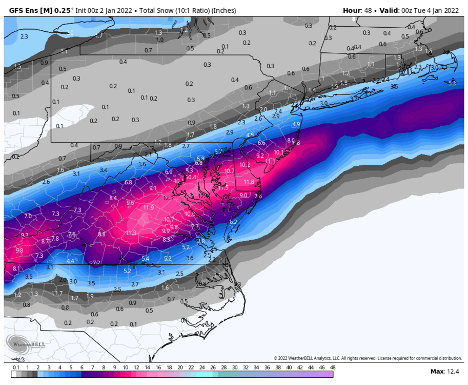
Looks like 06z GEFS 12 hr QPF has nudged higher and moved slightly NW
-
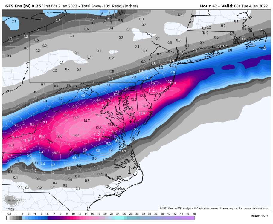
06z GFS Kuchera 06z GFS snow depth change
-
QPF cut back slightly
-
29 and ripping fatties on 06z GFS at DCA at 30
-
URGENT - WINTER WEATHER MESSAGE National Weather Service Baltimore MD/Washington DC 428 AM EST Sun Jan 2 2022 VAZ036-508-021730- /O.NEW.KLWX.WS.W.0001.220103T0600Z-220103T1800Z/ Nelson-Central Virginia Blue Ridge- 428 AM EST Sun Jan 2 2022 ...WINTER STORM WARNING IN EFFECT FROM 1 AM TO 1 PM EST MONDAY... * WHAT...Heavy snow with snow accumulations of 4 to 6 inches. * WHERE...Nelson County, and Central Virginia Blue Ridge. * WHEN...From 1 AM to 1 PM EST Monday. * IMPACTS...Travel could be very difficult. The hazardous conditions could impact the morning commute.
-
URGENT - WINTER WEATHER MESSAGE National Weather Service Baltimore MD/Washington DC 428 AM EST Sun Jan 2 2022 VAZ025>027-029-030-037>040-050-051-501>504-507-WVZ505-506-021730- /O.NEW.KLWX.WW.Y.0001.220103T0600Z-220103T1800Z/ Augusta-Rockingham-Shenandoah-Page-Warren-Albemarle-Greene- Madison-Rappahannock-Orange-Culpeper-Northern Fauquier- Southern Fauquier-Western Highland-Eastern Highland- Northern Virginia Blue Ridge-Western Pendleton-Eastern Pendleton- 428 AM EST Sun Jan 2 2022 ...WINTER WEATHER ADVISORY IN EFFECT FROM 1 AM TO 1 PM EST MONDAY... * WHAT...Snow. Additional snow accumulations of 2 to 4 inches. * WHERE...Portions of central, northern, northwest and western Virginia and eastern West Virginia. * WHEN...From 1 AM to 1 PM EST Monday. * IMPACTS...Plan on slippery road conditions. The hazardous conditions could impact the morning commute.
-
URGENT - WINTER WEATHER MESSAGE National Weather Service Baltimore MD/Washington DC 428 AM EST Sun Jan 2 2022 DCZ001-MDZ013-014-016>018-VAZ052>057-021730- /O.NEW.KLWX.WS.A.0001.220103T0600Z-220103T1800Z/ District of Columbia-Prince Georges-Anne Arundel-Charles- St. Marys-Calvert-Prince William/Manassas/Manassas Park-Fairfax- Arlington/Falls Church/Alexandria-Stafford-Spotsylvania- King George- 428 AM EST Sun Jan 2 2022 ...WINTER STORM WATCH IN EFFECT FROM LATE TONIGHT THROUGH MONDAY AFTERNOON... * WHAT...Heavy snow possible. Total snow accumulations of 3 to 6 inches possible. * WHERE...Portions of The District of Columbia, central and southern Maryland and central and northern Virginia. * WHEN...From late tonight through Monday afternoon. * IMPACTS...Plan on slippery road conditions. The hazardous conditions could impact the morning commute.
-
Damn... from morning LWX AFD "The most likely snowfall forecast should be used with caution, with probabilities of higher amounts, towards the 90th percentile, should strongly be considered for planning purposes. Please continue to check back as we modify this forecast in the coming hours."
-
Winter Storm Watches/warnings issued by LWX
-
06z RGEM snow 00z RGEM snow
-

Southern MD / Lower Eastern Shore weather discussion
yoda replied to AnEndlessMaze's topic in Mid Atlantic
URGENT - WINTER WEATHER MESSAGE National Weather Service Mount Holly NJ 357 AM EST Sun Jan 2 2022 DEZ002>004-MDZ015-019-020-NJZ021>025-022200- /O.NEW.KPHI.WS.A.0001.220103T0800Z-220103T2200Z/ Kent-Inland Sussex-Delaware Beaches-Queen Annes-Talbot-Caroline- Cumberland-Atlantic-Cape May-Atlantic Coastal Cape May- Coastal Atlantic- Including the cities of Dover, Georgetown, Rehoboth Beach, Centreville, Easton, Denton, Millville, Hammonton, Cape May Court House, Ocean City, and Atlantic City 357 AM EST Sun Jan 2 2022 ...WINTER STORM WATCH IN EFFECT FROM LATE TONIGHT THROUGH MONDAY AFTERNOON... * WHAT...Heavy snow possible. Total snow accumulations of at least 4 to 6 inches possible. Winds could gust as high as 35 mph. * WHERE...Portions of southern New Jersey, northeast Maryland and central and southern Delaware. * WHEN...From late tonight through Monday afternoon. * IMPACTS...Travel could be very difficult. Hazardous conditions including snow-covered roads will likely impact the Monday morning commute, potentially lingering into the evening commute. * ADDITIONAL DETAILS...Snowfall rates could exceed one inch per hour at times Monday morning. Users should closely monitor the forecast today, as additional changes, potentially significant, are possible. -
06z RGEM shifts NW DCA went from 0.6" qpf on 00z run to 0.9" qpf on 06z run
-

Southern MD / Lower Eastern Shore weather discussion
yoda replied to AnEndlessMaze's topic in Mid Atlantic
URGENT - WINTER WEATHER MESSAGE National Weather Service Wakefield VA 352 AM EST Sun Jan 2 2022 MDZ021>024-VAZ075-076-517-519-521-522-021700- /O.NEW.KAKQ.WS.A.0001.220103T0800Z-220103T2100Z/ Dorchester-Wicomico-Somerset-Inland Worcester-Westmoreland- Richmond-Western King William-Western King and Queen- Western Essex-Eastern Essex- Including the cities of Cambridge, Salisbury, Crisfield, Princess Anne, Snow Hill, Sandy Point, Westmoreland, Colonial Beach, Leedstown, Oak Grove, Potomac Beach, Potomac Mills, Naylors Beach, Downing, Emmerton, Ethel, Farnham, Haynesville, Kennard, Aylett, Beazley, Biscoe, Henley Fork, Indian Neck, Newtown, Owenton, Saint Stephens Church, Tappahannock, and Dunnsville 352 AM EST Sun Jan 2 2022 ...WINTER STORM WATCH IN EFFECT FROM LATE TONIGHT THROUGH MONDAY AFTERNOON... * WHAT...Heavy wet snow possible. Total snow accumulations of 2 to 5 inches possible. Winds could gust as high as 35 mph. * WHERE...Portions of southeast Maryland and east central Virginia. * WHEN...From late tonight through Monday afternoon. * IMPACTS...Plan on slippery road conditions. The hazardous conditions could impact the morning commute. -
Hello there URGENT - WINTER WEATHER MESSAGE National Weather Service Wakefield VA 352 AM EST Sun Jan 2 2022 VAZ048-060>062-064-067>069-509>511-513-515-021700- /O.NEW.KAKQ.WS.A.0001.220103T0800Z-220103T1800Z/ Fluvanna-Prince Edward-Cumberland-Goochland-Caroline-Nottoway- Amelia-Powhatan-Western Louisa-Eastern Louisa-Western Hanover- Western Chesterfield- Western Henrico (Including the City of Richmond)- Including the cities of Bybee, Central Plains, Cunningham, Lake Monticello, Nahor, Palmyra, Troy, Farmville, Angola, Guinea Mills, Hawk, Raines Tavern, Reeds, Stoddert, Goochland, Corbin, Burruss Corner, Cedar Fork, Dawn, Crewe, Earls, Mannboro, Scotts Fork, Amelia Courthouse, Chula, Denaro, Jetersville, Fine Creek Mills, Flat Rock, Goodwins Store, Subletts, Worshams, Clayville, Genito, Louisa, Mineral, Ashland, Bon Air, Midlothian, and Richmond 352 AM EST Sun Jan 2 2022 ...WINTER STORM WATCH IN EFFECT FROM LATE TONIGHT THROUGH MONDAY AFTERNOON... * WHAT...Heavy wet snow possible. Total snow accumulations of 2 to 5 inches possible. * WHERE...Portions of central, north central and south central Virginia. * WHEN...From late tonight through Monday afternoon. * IMPACTS...Plan on slippery road conditions. The hazardous conditions could impact the morning commute.
-
From AKQ URGENT - WINTER WEATHER MESSAGE National Weather Service Wakefield VA 352 AM EST Sun Jan 2 2022 VAZ048-060>062-064-067>069-509>511-513-515-021700- /O.NEW.KAKQ.WS.A.0001.220103T0800Z-220103T1800Z/ Fluvanna-Prince Edward-Cumberland-Goochland-Caroline-Nottoway- Amelia-Powhatan-Western Louisa-Eastern Louisa-Western Hanover- Western Chesterfield- Western Henrico (Including the City of Richmond)- Including the cities of Bybee, Central Plains, Cunningham, Lake Monticello, Nahor, Palmyra, Troy, Farmville, Angola, Guinea Mills, Hawk, Raines Tavern, Reeds, Stoddert, Goochland, Corbin, Burruss Corner, Cedar Fork, Dawn, Crewe, Earls, Mannboro, Scotts Fork, Amelia Courthouse, Chula, Denaro, Jetersville, Fine Creek Mills, Flat Rock, Goodwins Store, Subletts, Worshams, Clayville, Genito, Louisa, Mineral, Ashland, Bon Air, Midlothian, and Richmond 352 AM EST Sun Jan 2 2022 ...WINTER STORM WATCH IN EFFECT FROM LATE TONIGHT THROUGH MONDAY AFTERNOON... * WHAT...Heavy wet snow possible. Total snow accumulations of 2 to 5 inches possible. * WHERE...Portions of central, north central and south central Virginia. * WHEN...From late tonight through Monday afternoon. * IMPACTS...Plan on slippery road conditions. The hazardous conditions could impact the morning commute.
-
Snow may be heavy at times has entered the zone forecast products
-
You wouldn't mind sharing that awesome recipe wouldn't you? The sweet bread that is
-
Wizards... lol. Remember when they were like 10-4? Yeah...
-
Weee lol... around an inch in DC and quickly increases the farther south and southeast you go. EZF is 3 to 4 inches
-
Like look at the snow map (yeah yeah I know)


