Chrisrotary12
-
Posts
7,085 -
Joined
-
Last visited
Content Type
Profiles
Blogs
Forums
American Weather
Media Demo
Store
Gallery
Everything posted by Chrisrotary12
-
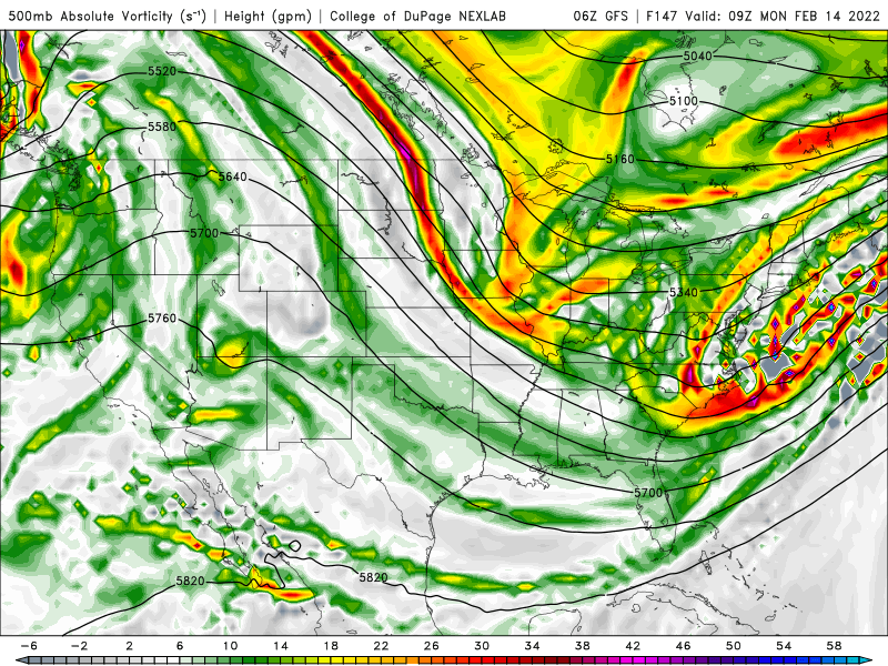
GFS shows this perfectly. Mean storm track just a bit too far west.
-
Ding dong my pack is gone, my pack is gone, my snowpack is really gone!
-
Can we shift the mean storm track from the 00z GFS/Euro east just a little?
-
Just enough to barely whiten the ground.
-
You know the ICON is a JV model when I have to go to 3 different websites to find it. Finally found it on TropicalTidbits.
-
Suppose I find the meteorology of each system much more enjoyable than then amount of snow that my driveway receives. To each his own.
-
I bitch that other people are constantly bitching.
-
The in my backyard stance of this forum is ridiculous.
-
What an ice rink out there this morning. All the melt yesterday froze overnight. DPW just had to drive by and drop sand.
-
My comment was more focused on the fact that basically the entire region got whacked with that one.
-
Winter storm of yore. They don't make them like they used to.
-
Melting nicely out there right now.
-
Can we start a separate misery measuring contest thread?
-
I will say that the large scale ridge-trough pattern is there for an east coast storm. However, there are two kickers in the flow mucking things up. The vort over St. Louis dropping in doesn't phase in time and the just off screen vort slamming into British Columbia shifts the whole pattern east.
-
Is there the thread where we talk about the pattern flip to spring?
-
Ray mentioning the last 4 years snow in his area is the new Hadley cell.
-
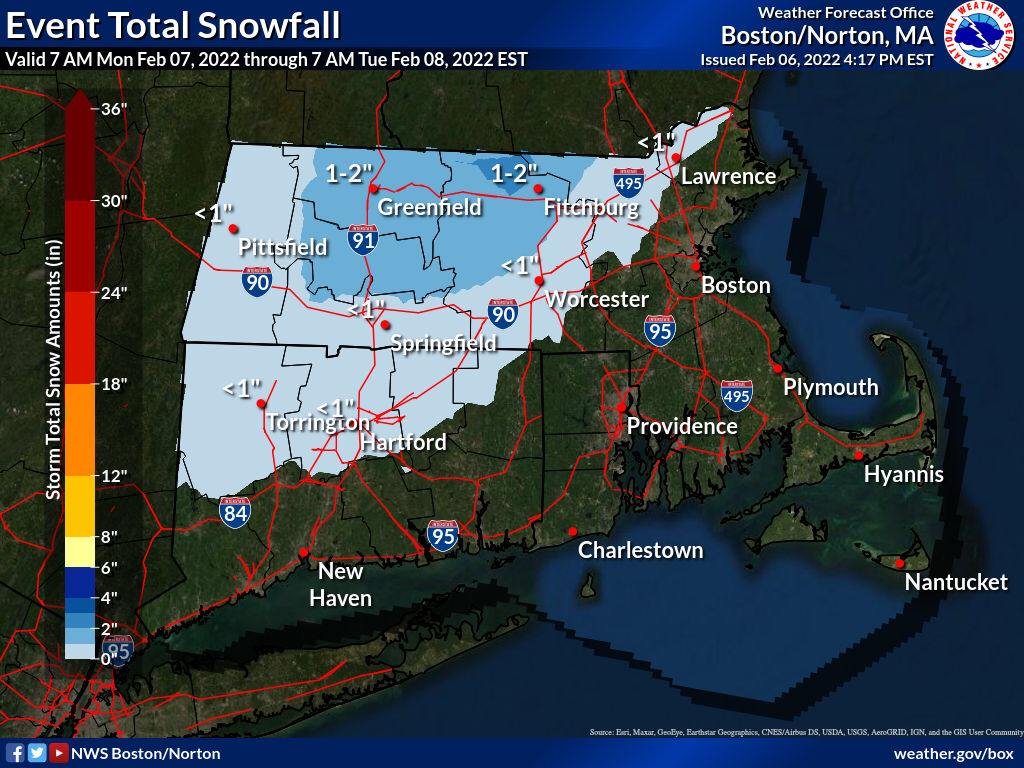
Technically the title of the thread says Feb 8. Today is the 7th.
-
Snowy?

-
Impressive parade of misses on GFS & Euro. Ensembles don’t look any more promising. Best hope appears to be Ginxy’s 14th storm.
-
Wife & I were awoken this morning at 3:05a and sat right up in bed from what I can only describe as a loud bang. After searching house and finding nothing, I fully expected to find a tree on my house this morning. Thankfully, nothing. Best I can figure is an ice quake. No obvious sources of sound around neighborhood.
-
Still has the system. That's all that matters at this point.
-
I know. But no one actually posts there. Instead they clog up every legitimate thread with "woe is me" posts and crap.
-
We need a misery thread for you people. 18z NAM looks good so far.
-
06z NAM looks like a best case scenario right now.
-
The amount of in my backyard bitching in this place is insane. Can we at least do it here or the panic thread?