msuwx
-
Posts
673 -
Joined
-
Last visited
Content Type
Profiles
Blogs
Forums
American Weather
Media Demo
Store
Gallery
Everything posted by msuwx
-
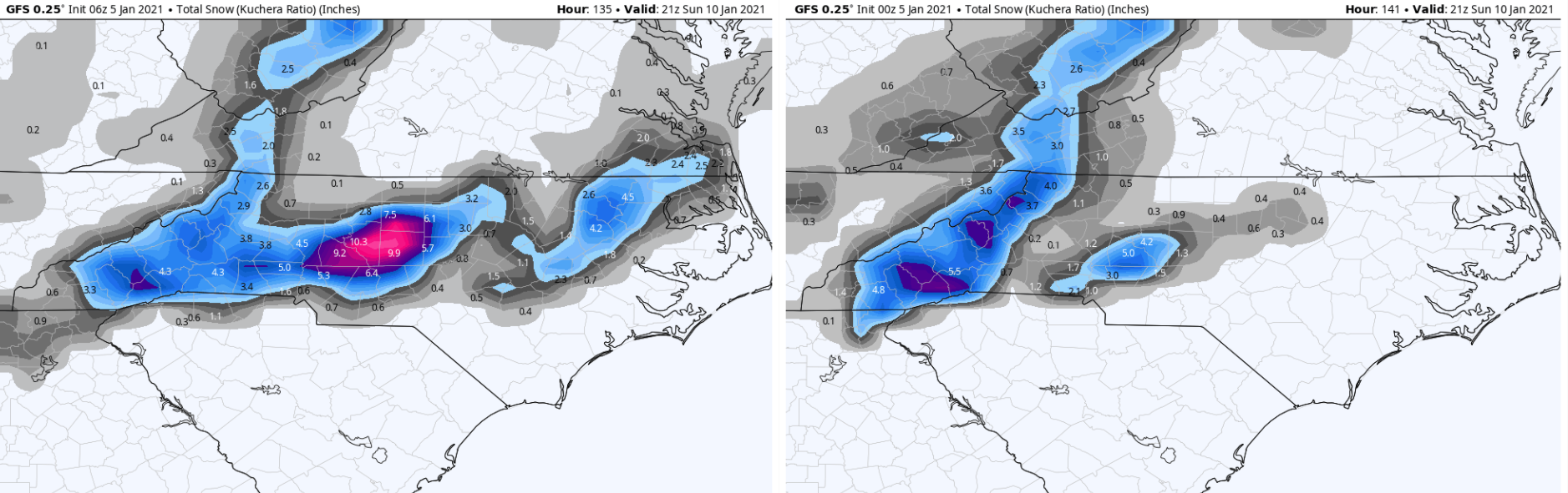
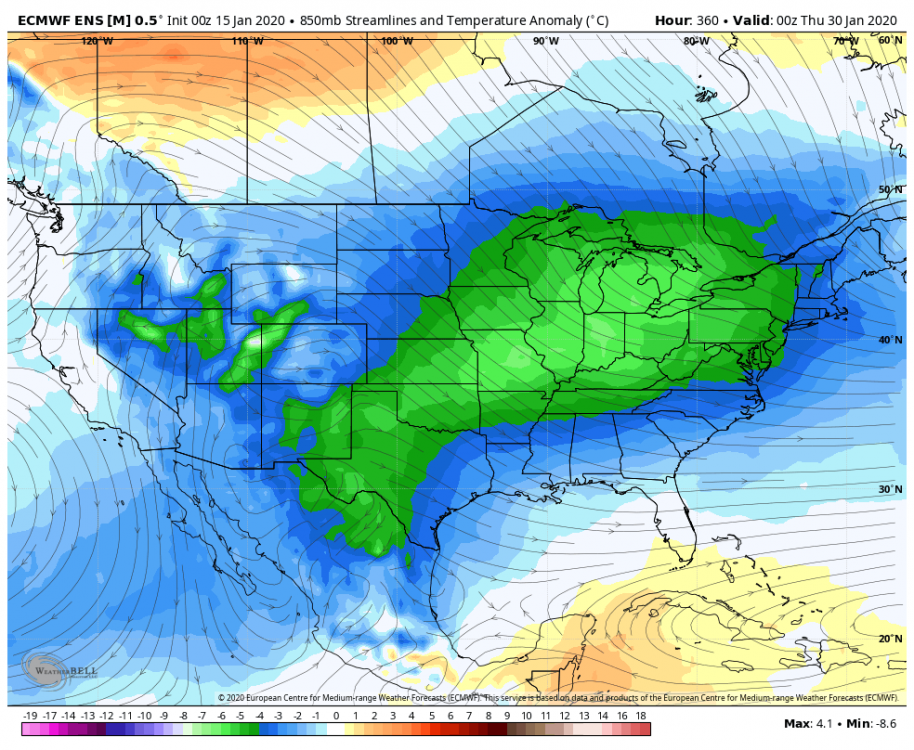
While it isn't as aggressive as some other models, the 6z GFS actually beefed up the snow totals in much of NC compared to its 0z run. See the comparison below:

-
??
-
I think we’ve lost about 37 straight....
-
Yeah the wet bulb will probably remain above freezing in CLT throughout the precip time-frame. Going to take some great rates to overcome the 'warm-ish' boundary layer enough to accumulate. I'm not crazy about the overall look from CLT-GSP, but we will see. Radar looks good though.
-
On the 12z Canadian, there's much less upper level (500mb) dynamics involved because of the handling of the vort moving out of the Rockies into the Plains Thursday morning. 0z GEM kept it rolling southeast and there was a degree of phasing of the system, leading to the NW side of our coastal low blossoming with precip. 12z GEM takes the Rockies vort to the ENE (rather odd-looking) and you get little to no interaction with it and our coastal system.
-
I really like the odds of a nice, west-east oriented area of overrunning snow with this system. The setup is ripe for that, assuming we get decent precip rates. The air aloft is plenty cold for snow, and only gets colder as the event unfolds. The question is will the band with the right balance of cold air/ precipitation overlap to generate snow be in northern SC, southeastern NC, further north, or will precip remain too light to really generate any accumulating snow in most places. Too soon to know.
-
That’s the old Euro bias.
-
Pet peeve alert.... This is largely a board for weather enthusiasts. It gets very old when the flood of the same, tired, snide comments come in after someone posts a medium-range model map. I think everyone reading this board is aware a single run of a deterministic model (or single ensemble member) will likely never verify in the extended medium range. But what are people supposed to post? A picture of an overcast sky? The purpose of the board is to discuss whatever there is to discuss, and unfortunately for snow fans, medium-range snapshots are about all we've got. End of rant... back to your regularly-scheduled programming.
-
The 'it doesn't get cold anymore' narrative gets tiresome.
-
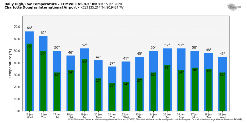
12z EPS for KCLT
-
That’s 4.5 days after the map you posted. So yes, that’s pretty quick rebuilding of the cold. But we will see....
-
Last frame of the 0z EPS
-
Even taking the 0z EPS at face value, that is nothing that resembles ‘warm.’
-
That is not even remotely correct.
-
12z NAM in BUFKIT is much less pronounced with the warm nose for KHKY that it was on the 6z run.... FWIW.
-
If the warmer temps aloft are correct, I think CLT stays sub-freezing at the SFC longer than RDU, at least a by a bit. However, I am not totally sold on the warmer aloft solution. Couple of normally-reliable tools aren't in that camp.
-
Well, been pouring through all available data for hours now, and it all depends on the temperatures 5-9k feet aloft for much of the region tonight into Sunday morning. NAM really warms temps in those layers later tonight....some other models do not. The NAM often does well in this situation, but I'm more hesitant than normal this time. Makes a massive difference in ground accumulations, especially around CLT-RDU corridor.
-
FYI.....for those concerned about what wording the RAH NWS uses publicly, you can expect them to really beef up their wording this afternoon.
-
Read this RE: NAM..... Just poured through the hour-by-hour profiles for KCLT in BUFKIT from the 6z NAM.... 12z wasn't in yet. Really fascinating. Even out to 3-4z Sunday, the dewpoint is ABOVE freezing from essentially the SFC up to around 5k feet. Then, extremely quickly and dramatically, EXTREME drying kicks in at 2k-4k feet over the next few hours... I mean extreme. Dewpoints drop 10s of degrees C at those layers as strong NE winds kick in at those levels. That is when the dynamic cooling really starts to kick in.... which is after the end of the 3k NAM's range that someone posted a moment ago. Interesting. Compared to the 6z GFS, the NAM atmospheric profile is warmer by a decent margin than the GFS at precip onset. BUT, this isn't due to a warm nose....it's the initial airmass. At this point, for that aspect of the system, I would still give a slight lean to the globals.
-
6z GFS had a good bit of snow for KCLT, per BUFKIT.
-
Time for my semi-annual pet peeve post. One shift does not equal a “trend.” You need multiple, subsequent movements of something in the same direction for it to be a trend. In other words, multiple model cycles in a row, not 1.
-
EPS as well as the control increase once again..... the control run was crazy.
-

The December to Remember 7th-8th blue turd winter threat thread.
msuwx replied to lilj4425's topic in Southeastern States
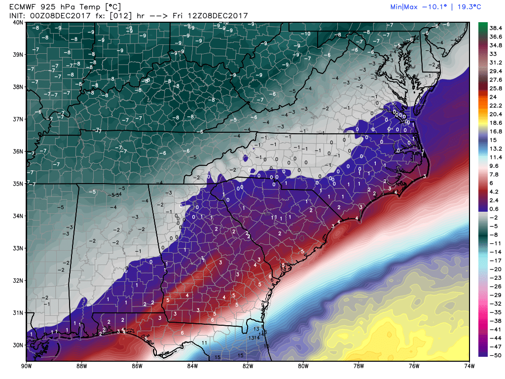
The 925mb temperatures seem to be behaving very similarly to what the European model projected. Actual vs. model: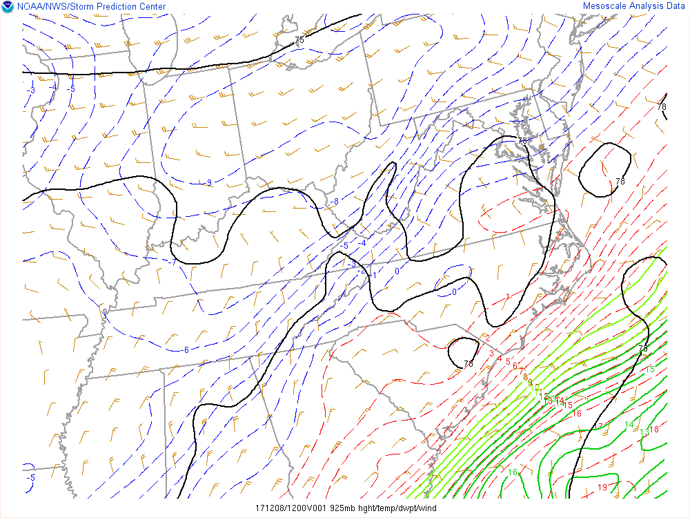

-
The December to Remember 7th-8th blue turd winter threat thread.
msuwx replied to lilj4425's topic in Southeastern States
6z GFS ensembles could very well have been the warning shot. -
The December to Remember 7th-8th blue turd winter threat thread.
msuwx replied to lilj4425's topic in Southeastern States
I think conservative is the way to go for the time being, and that's the way I continue to go in my public forecast. Way too many variables and too much uncertainty to be too whipped up into a frenzy at this juncture.