msuwx
-
Posts
678 -
Joined
-
Last visited
Content Type
Profiles
Blogs
Forums
American Weather
Media Demo
Store
Gallery
Everything posted by msuwx
-
I also am interested to see how quickly this weakens. A lot of mesoscale models really show this thing dramatically falling apart as it nears landfall. Big time.
-
Interesting dichotomy between radar presentation (which still looks quite healthy) and the significantly degraded satellite presentation.
-
 Not surprising. You can usually 'subtract' a category from the intensity impacts for a weakening system. It will be interesting to see how this survives. I think it is going to emerge quite weak from the Yucatan since it was weakening and hit land at the 'wrong' time. Yucatan can often take quite a toll on systems. I always think of Isidore (2002)..... it lost its inner core of the Yucatan and never got it back.
 -
Port Royal/ Kingston could take a really rough hit from storm surge I would imagine, especially if the center tracks near or just south. Shape of the topography would only hurt in this scenario.
-
Writing off 21 days with tons of arctic air in the pattern is an interesting position.
-
Clearly seems to be beginning an ERC which will probably help the wind-aspect of this system for coastal Florida. Also, if that is the case, could cause weakening once inland a little more quickly than expected.
-
-
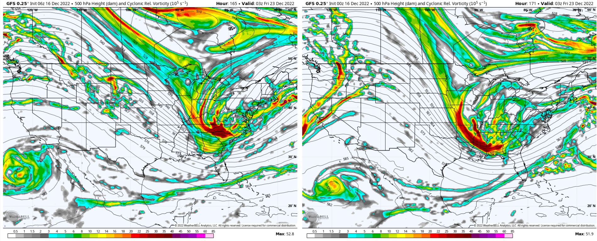
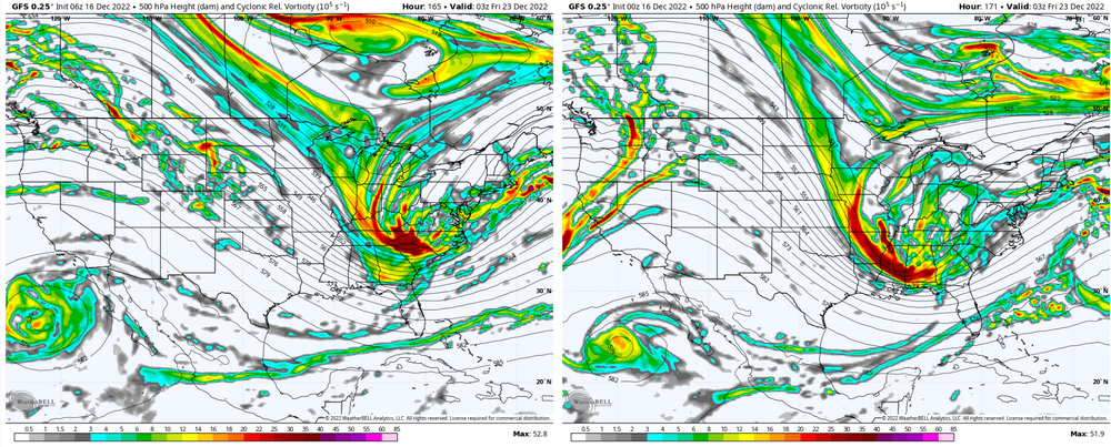
Biggest takeaway is that it came in way, way stronger at 500mb than the previous run. I mean a lot stronger. Exactly how that closes off, and how the vort energy causes the ULL to wobble, to make a big difference for folks in the western Carolinas.
-
Stronger system, much more pronounced warm nose ahead of it at 60-63 hours. ULL is much deeper at that point over MS/AL compared to 6z.
-
This (12z) NAM run looks like it will turn out fun.
-
Folks complaining about the overnight runs must not have been paying attention this winter. At least it's something.
-
Not exactly correct.
-
The Euro took a big step west with the diving energy in the Plains compared to its 0z run. Significant adjustment IMO. 0z: 12z:
.thumb.png.0bd2d4839f1590c9e037fd9c89ec0211.png)
.thumb.png.00cedc6b7573aee92565767bb27b28bc.png)
-
6z GFS is definitely still a hit of snow for a lot of the region. But yes, it is a later, further east phase/ digging.... not what most would want. 6z compared to 0z:
.thumb.png.cb66176a47524ab8c2b42e7b87196351.png)
-
I can tell you from talking personally to someone this morning in Cape Coral.... they are staying but have a 'go' bag ready. I tried to tell them when the surge comes in, it will come quickly and it will then be too late.
-
I have not dug deeply into the longer range this morning, but when I did yesterday, I saw nothing at all that signaled an end to winter anytime soon.
-
Potential 1/28-1/30 2022 winter storm
msuwx replied to Prismshine Productions's topic in Southeastern States
That was it! And yes they did.... that areas has had it rough! -
Potential 1/28-1/30 2022 winter storm
msuwx replied to Prismshine Productions's topic in Southeastern States
I still have painful memories of an event a few years ago. Looked good for a big Charlotte snow.... went to dinner and huge flakes were flying. Felt good about my forecast. Walked out of dinner to head to the hotel..... and sleet was falling. Knew it was over then. That's the event that I vowed to never take the NAM's warm nose projections lightly. -
Potential 1/28-1/30 2022 winter storm
msuwx replied to Prismshine Productions's topic in Southeastern States
Prior to this winter, I don't think there has been a more prolific screwzone in the region than the Charlotte metro....especially western and southern Charlotte metro. It's nice to finally see that reversed a bit. -
Potential 1/28-1/30 2022 winter storm
msuwx replied to Prismshine Productions's topic in Southeastern States
Say what you will, having 3 winter weather events, to some degree, in 20 days is very impressive to me. Some spots in western NC had snow on snow on snow, which is pretty dang rare (I've never experienced it personally before), outside of the higher mountain spots. -
Potential 1/28-1/30 2022 winter storm
msuwx replied to Prismshine Productions's topic in Southeastern States
You should try on for size the volume of high school basketball games we’ve had to cancel this month. -
Potential 1/28-1/30 2022 winter storm
msuwx replied to Prismshine Productions's topic in Southeastern States
I think there’s just more uncertainty than normal that that snow band will set up and exactly where it will. Probably better to play it very conservative and ramp-up than the other way around. could be one of those things where a lot of the accumulations that do occur or mainly on the grassy and elevated surfaces with it taking a while for the surface temperatures to cool. Then again, if this band performs well with rates as some previous setups have done, that won’t matter much. -
Potential 1/28-1/30 2022 winter storm
msuwx replied to Prismshine Productions's topic in Southeastern States
This one is quite vexing because of the lack of support for the UL-induced band with the RGEM and NAM. I still feel fairly confident it happens….but what a low confidence forecast. -
Potential 1/28-1/30 2022 winter storm
msuwx replied to Prismshine Productions's topic in Southeastern States
That's some random other little low that developed by hour 57. Not the main low. The main upper forcing is just arriving. -
Potential 1/28-1/30 2022 winter storm
msuwx replied to Prismshine Productions's topic in Southeastern States
Yeah a lot of the modeling is consolidating around the idea of that nice band of snow/ snow showers working through western and central NC. Entirely dependent on upper levels though, so time will tell.


.png.70f059a481e120f1ff61396d2c796ee5.png)
.png.c4860439128efcb8dfd101f127cea2b0.png)

.png.05cb24c7425fc45b46b83a3b72713c22.png)