OSUmetstud
-
Posts
16,433 -
Joined
-
Last visited
Content Type
Profiles
Blogs
Forums
American Weather
Media Demo
Store
Gallery
Everything posted by OSUmetstud
-
Upstate/Eastern New York
OSUmetstud replied to BuffaloWeather's topic in Upstate New York/Pennsylvania
okay. enjoy. -
Upstate/Eastern New York
OSUmetstud replied to BuffaloWeather's topic in Upstate New York/Pennsylvania
Yeah, I'm saying Blasdell etc. doesn't average more than BUF. BUF has an advantage of being more inland. -
Upstate/Eastern New York
OSUmetstud replied to BuffaloWeather's topic in Upstate New York/Pennsylvania
Wind chill warning is for later today into tonight, when the core of the arctic air arrives and the winds increase. -
Upstate/Eastern New York
OSUmetstud replied to BuffaloWeather's topic in Upstate New York/Pennsylvania
Right, but nowhere near a few miles of the lakeshore and near the lake plain elevation averages more than 100". I can't seem to find BUF's good snowfall climo map. It shows the same thing I'm discussing. Village of Hamburg and Op is definitely more, but near Route 20...its near BUF, and down by route 5 its actually probably less than BUF. -
Upstate/Eastern New York
OSUmetstud replied to BuffaloWeather's topic in Upstate New York/Pennsylvania
Depends where, I think. Out by southwestern its only a bit more, but it increases as you get further east and go up in elevation. -
Upstate/Eastern New York
OSUmetstud replied to BuffaloWeather's topic in Upstate New York/Pennsylvania
That's just a regression to climo anyway. The last several years have been very southtowns oriented, more so than climo would suggest. BUF and west seneca are almost the same climo, I think OP and Hamburg would be a bit more than BUF. -
Upstate/Eastern New York
OSUmetstud replied to BuffaloWeather's topic in Upstate New York/Pennsylvania
I was originally surprised that BUF hadn't issue a blizzard warning like they did in 2014, but the winds have been underwhelming compared to that event and the 85 event. There hasn't been a single ob of blizzard conditions at BUF for this whole event. -
The long range looks better than it has in some time for many. I endorse the look. Deep PV over the midwest and eastern US isn't a good look most of the time for New England and for Atlantic Canada.
-
Upstate/Eastern New York
OSUmetstud replied to BuffaloWeather's topic in Upstate New York/Pennsylvania
I actually think the very cold airmass and glaciation of clouds would lead to less inland extent than an earlier season band. -
Upstate/Eastern New York
OSUmetstud replied to BuffaloWeather's topic in Upstate New York/Pennsylvania
love me some panic -
Upstate/Eastern New York
OSUmetstud replied to BuffaloWeather's topic in Upstate New York/Pennsylvania
It does kinda work for lake effect. I think that ratios should be generally in the 15-20:1 range. There should be some dendrites mixed today through this evening given VVs punching into the -18c layer closer to the ground. -
Upstate/Eastern New York
OSUmetstud replied to BuffaloWeather's topic in Upstate New York/Pennsylvania
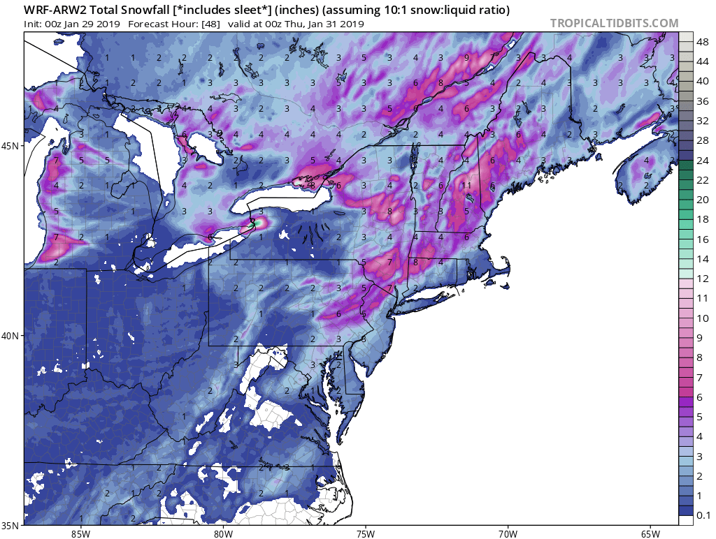
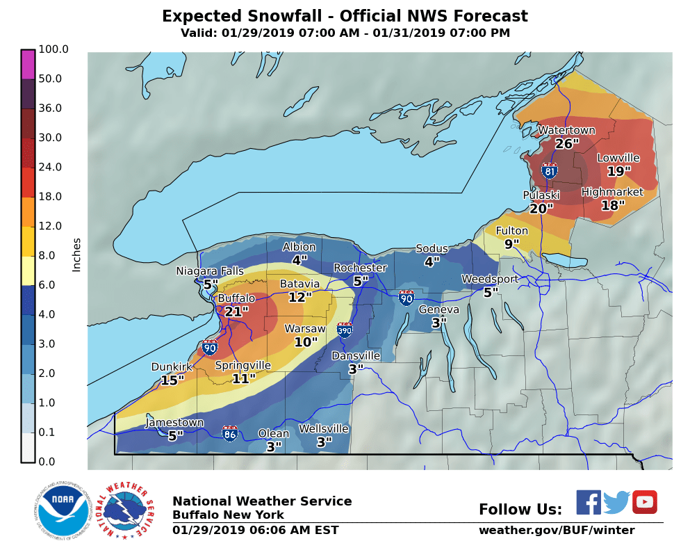
Some meso projections for the BUF area. Nice signal, but the typical pre-event disagreements.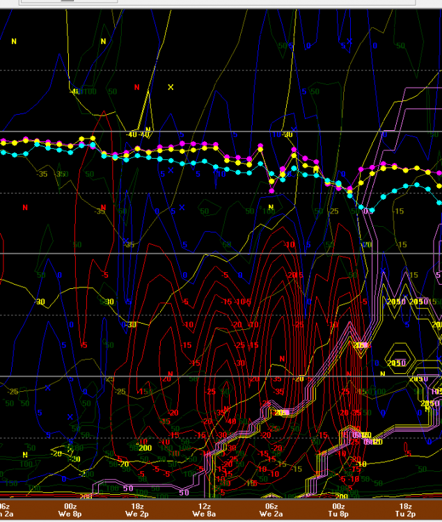


-
Upstate/Eastern New York
OSUmetstud replied to BuffaloWeather's topic in Upstate New York/Pennsylvania
That's where my old apt was during the nov 2014 storm. It's a really long duration event, I could see it. Specific totals are always pretty difficult. The band just be in the vicinity of the BUF from this afternoon to Wed afternoon. Most intense to me should be Wednesday morning into early afternoon when an approaching 700mb shortwave provides extra lift and moisture. -
Upstate/Eastern New York
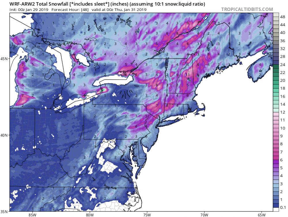
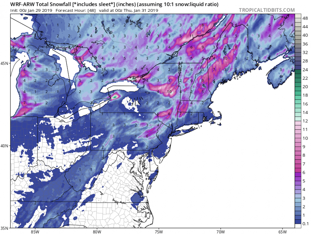
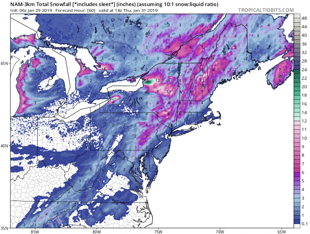
OSUmetstud replied to BuffaloWeather's topic in Upstate New York/Pennsylvania
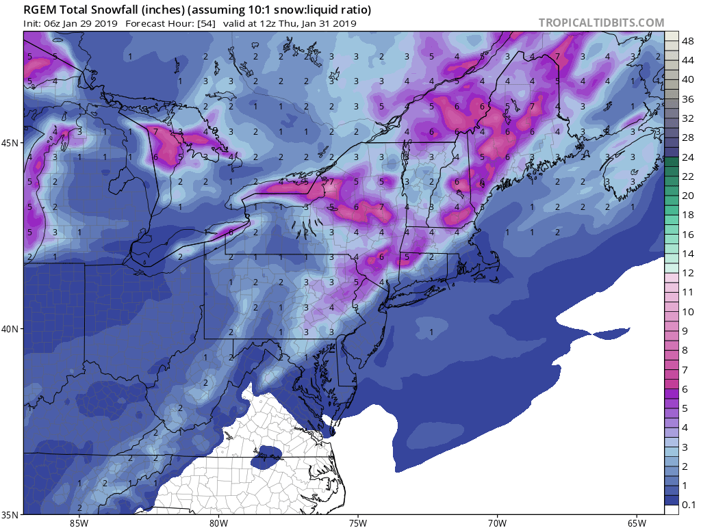
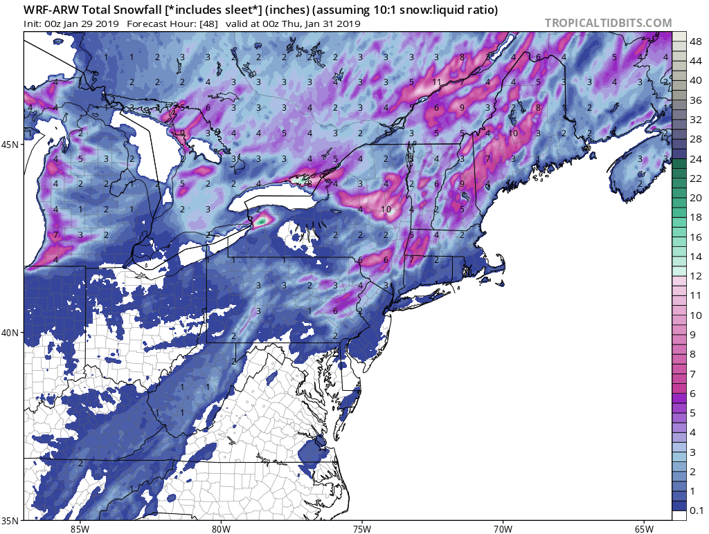
newest map from buf
-
Upstate/Eastern New York
OSUmetstud replied to BuffaloWeather's topic in Upstate New York/Pennsylvania
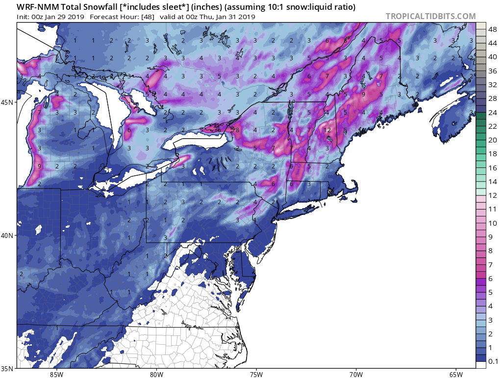
There's a decent amount of ice in the western basin. You can see it in gray here. I still think this will be a solid event, however.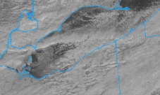
-
Ahh lol. I was kind surprised since ecmwf vastly outperforms gfs in all categories at day 10 and its ensemble is much more dispersive.
-
Can you link to it? Id like to see the data.
-
Who said this?
-
Upstate/Eastern New York
OSUmetstud replied to BuffaloWeather's topic in Upstate New York/Pennsylvania
Yep. Jealous. -
Upstate/Eastern New York
OSUmetstud replied to BuffaloWeather's topic in Upstate New York/Pennsylvania
Hasnt ws been in a relative sweet spot the last several years? -
Yes point taken the cad from the high does influence the track.
-
Yea. Its got a more subdued feb 2011 late jan 66 march 1888 look.
-
Wouldnt the low want to tend to get tugged west into the pv?
-
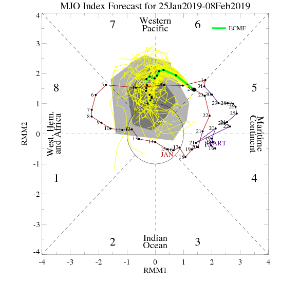
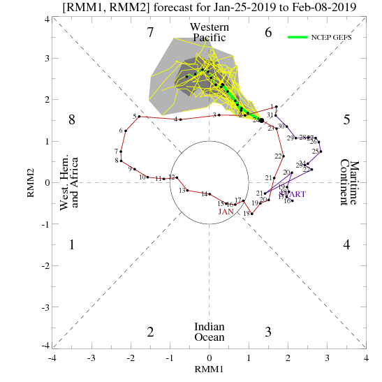
I fail to see that; the gfs and ecmwf show similar mjo progression. I think its just shortwave timing (like much of the winter). The mean ridge and trough generally look favorable through the run.
-
Upstate/Eastern New York
OSUmetstud replied to BuffaloWeather's topic in Upstate New York/Pennsylvania
It looks like ski country might be under the gun after this morning, then it lifts north into metro again tonight.