OSUmetstud
-
Posts
16,521 -
Joined
-
Last visited
Content Type
Profiles
Blogs
Forums
American Weather
Media Demo
Store
Gallery
Everything posted by OSUmetstud
-
I'm calling bs on the precip amounts being reported there.
-
Pretty convinced the niagara escarpment will end up the winner overall. The banding there lingers longer than anywhere else.
-
15" at BUF as of the latest metar, probably make a run for 20.
-
Widespread Snow Potential January 16th to January 18th
OSUmetstud replied to sferic's topic in Upstate New York/Pennsylvania
-
Widespread Snow Potential January 16th to January 18th
OSUmetstud replied to sferic's topic in Upstate New York/Pennsylvania
Theres sleet in Charleston WV right now. -
Widespread Snow Potential January 16th to January 18th
OSUmetstud replied to sferic's topic in Upstate New York/Pennsylvania
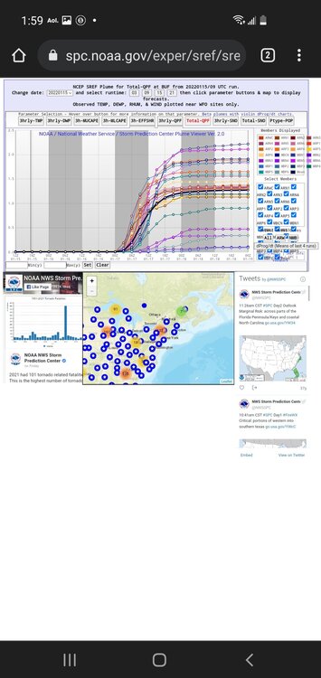
Where do you find the map? -
Widespread Snow Potential January 16th to January 18th
OSUmetstud replied to sferic's topic in Upstate New York/Pennsylvania
Thats because it is the 12z -
Widespread Snow Potential January 16th to January 18th
OSUmetstud replied to sferic's topic in Upstate New York/Pennsylvania
Euro ensemble mean.
-
Widespread Snow Potential January 16th to January 18th
OSUmetstud replied to sferic's topic in Upstate New York/Pennsylvania
There probably will be a blizzard right at the lakeshore. I've seen that in Oswego when I lived there too but from what I've seen BUF wouldn't issue a blizzard warning unless the conditions were more widespread than that. This storm doesn't have really cold air and high pressure on its nw flank to get really strong winds during the heaviest snowfall. -
Widespread Snow Potential January 16th to January 18th
OSUmetstud replied to sferic's topic in Upstate New York/Pennsylvania
It's probably underdone lol -
Widespread Snow Potential January 16th to January 18th
OSUmetstud replied to sferic's topic in Upstate New York/Pennsylvania
The drinking never stops in BUF. -
Widespread Snow Potential January 16th to January 18th
OSUmetstud replied to sferic's topic in Upstate New York/Pennsylvania
Yeah I'd think so...obviously it can go too far if it really moves se. -
Widespread Snow Potential January 16th to January 18th
OSUmetstud replied to sferic's topic in Upstate New York/Pennsylvania
Don't speak that into existence. -
Widespread Snow Potential January 16th to January 18th
OSUmetstud replied to sferic's topic in Upstate New York/Pennsylvania
Yeah there's more of a squeeze as the ov shortwave is coming in from the northwest. You can see the se movement from the Toronto decrease and Rochester increase. -
Widespread Snow Potential January 16th to January 18th
OSUmetstud replied to sferic's topic in Upstate New York/Pennsylvania
That's not where the increase occurred. It's because you dryslotted less in the initial heavier qpf part. The se upper level low and surface low was bodily a bit further southeast. -
Widespread Snow Potential January 16th to January 18th
OSUmetstud replied to sferic's topic in Upstate New York/Pennsylvania
Nah. It went se from the 00z and 06z runs. -
Widespread Snow Potential January 16th to January 18th
OSUmetstud replied to sferic's topic in Upstate New York/Pennsylvania
-
Widespread Snow Potential January 16th to January 18th
OSUmetstud replied to sferic's topic in Upstate New York/Pennsylvania
Also,.thumb.png.c7ccf0f619951f6bc07fc37f1186645b.png)
.thumb.png.c95bad34e86a0d624b3b877e9bc38d8e.png)
-
Widespread Snow Potential January 16th to January 18th
OSUmetstud replied to sferic's topic in Upstate New York/Pennsylvania
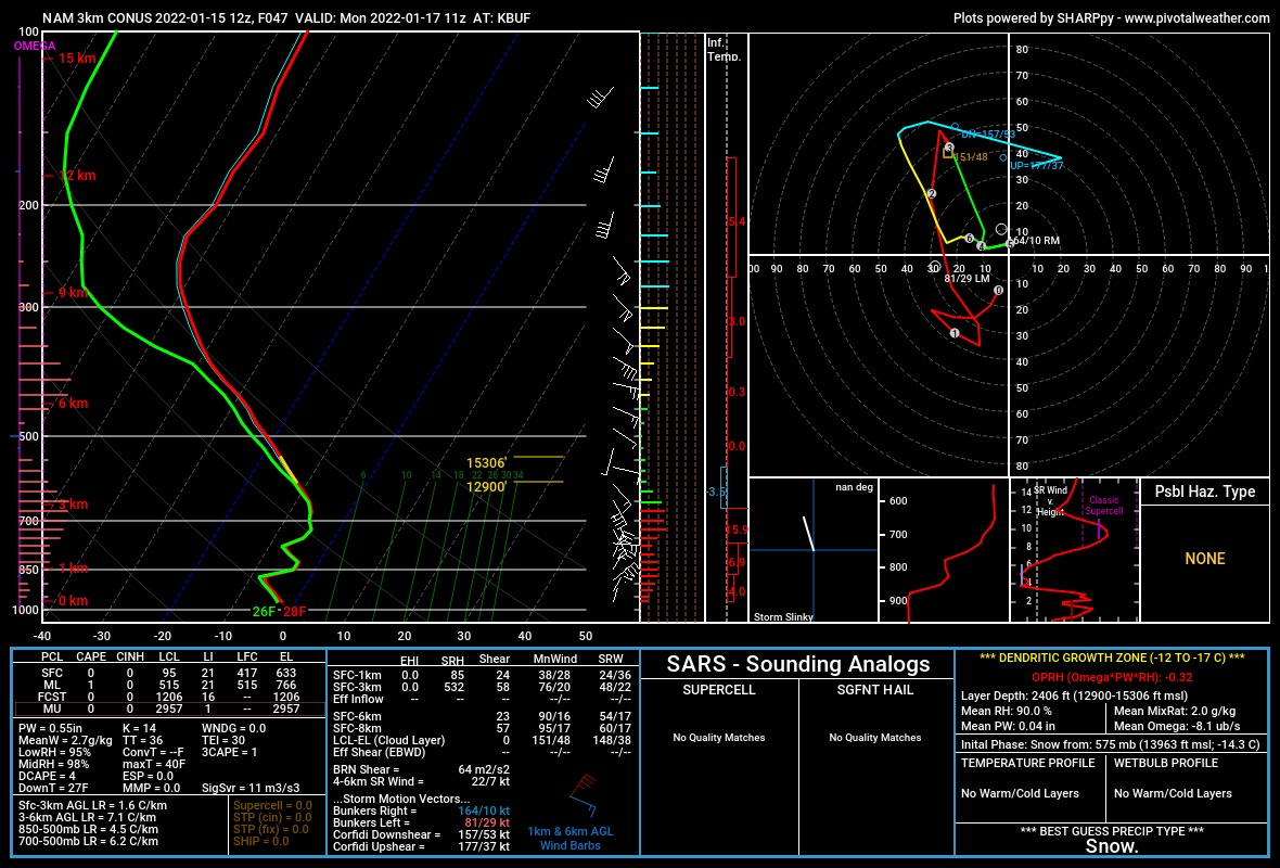
Possibly. Here is the nam3km at buf with steep 3 to 6km lapse rates of 7.1 c/km.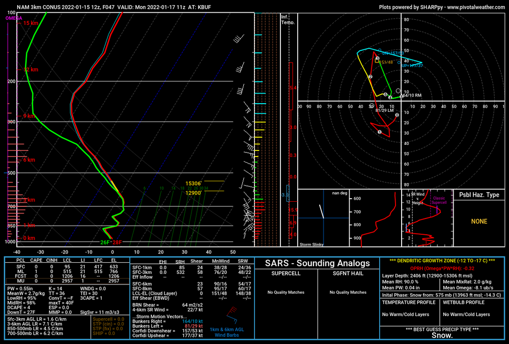
-
Widespread Snow Potential January 16th to January 18th
OSUmetstud replied to sferic's topic in Upstate New York/Pennsylvania
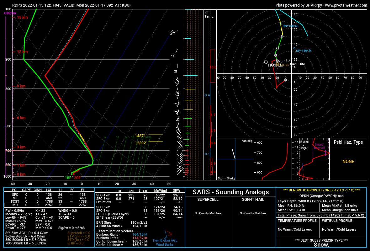
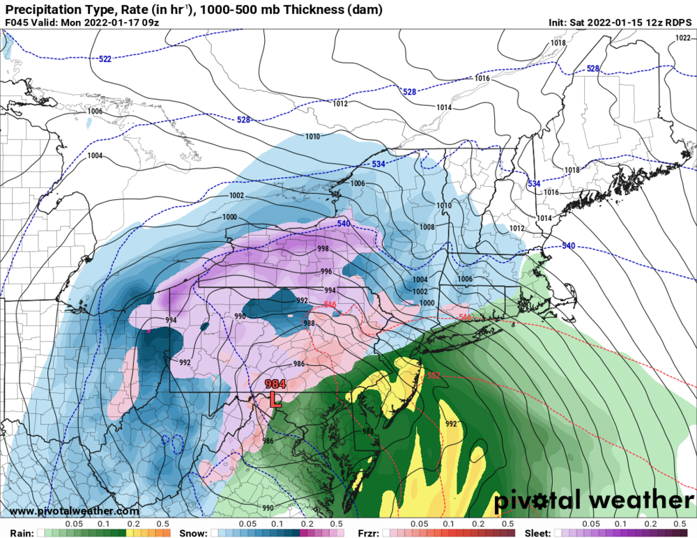
These algorithms seem a little too keen on mixing on the rdps to me. These soundings look like snow to me.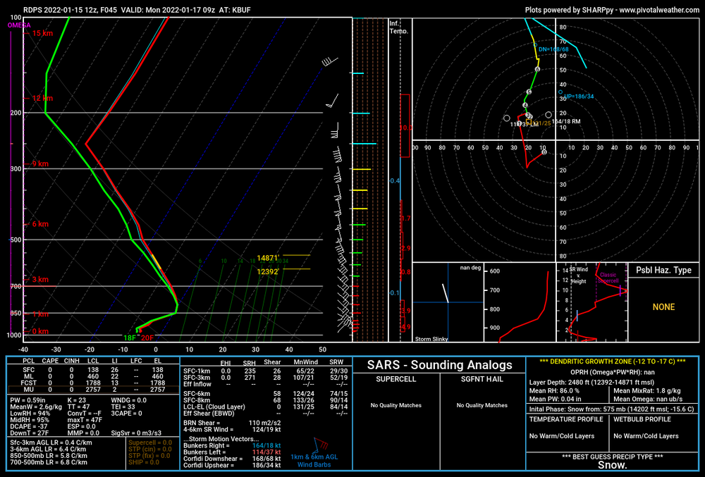
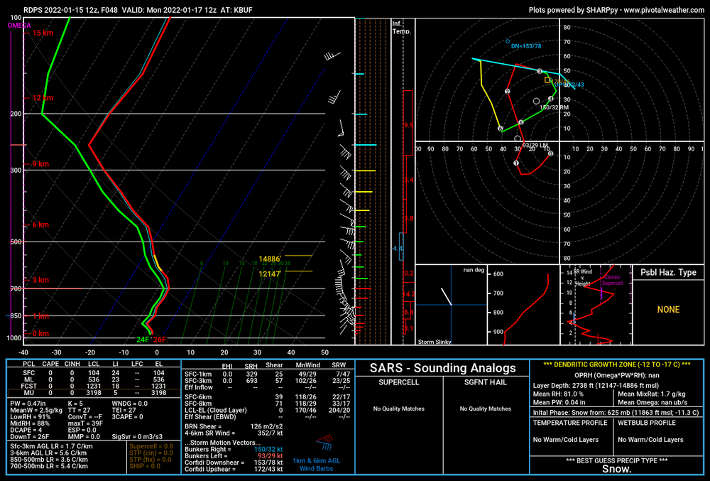
-
Widespread Snow Potential January 16th to January 18th
OSUmetstud replied to sferic's topic in Upstate New York/Pennsylvania
Wind and rain. It's been a shitty winter in Eastern NL so far. PEI and SE NB got the snow goods with this one. Well probably gust close to hurricane force tonight. -
Widespread Snow Potential January 16th to January 18th
OSUmetstud replied to sferic's topic in Upstate New York/Pennsylvania
Lol. I mean the that trough isn't pushing the storm off the coast. It's partially phasing with the southern low. -
Widespread Snow Potential January 16th to January 18th
OSUmetstud replied to sferic's topic in Upstate New York/Pennsylvania
It's a good discussion but I dont like calling that trough a kicker..its actually the reason this thing is getting tugged west and not slamming nyc and new england with snow. -
Widespread Snow Potential January 16th to January 18th
OSUmetstud replied to sferic's topic in Upstate New York/Pennsylvania
Prayers -
Widespread Snow Potential January 16th to January 18th
OSUmetstud replied to sferic's topic in Upstate New York/Pennsylvania
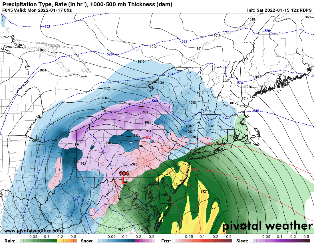
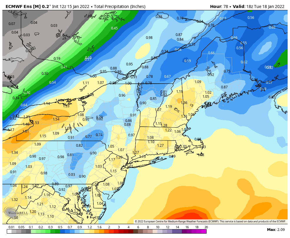
The Hudson Valley shadow for this event is really something. Very strong ese 850-900mb flow will do that.


.png.443275128854de0f5687cdaf53f85058.png)
.png.611ad2a0a07a4799ed96522e91d56e7e.png)