OSUmetstud
-
Posts
16,532 -
Joined
-
Last visited
Content Type
Profiles
Blogs
Forums
American Weather
Media Demo
Store
Gallery
Everything posted by OSUmetstud
-
Upstate NY Banter and General Discussion..
OSUmetstud replied to wolfie09's topic in Upstate New York/Pennsylvania
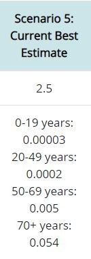
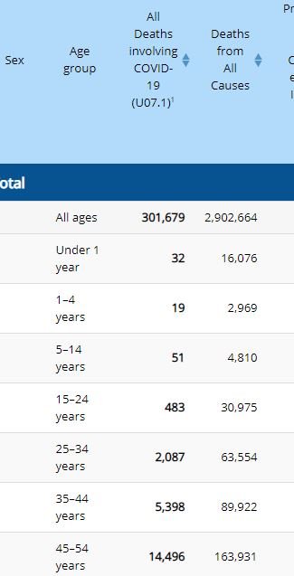
My 68-year old uncle is hospitalized with COVID19 in Pittsburgh. He's been feverish with lung and kidney issues. They have him on Remdesivir (whatever) and steroids. Hoping for the best there. This is the latest CDC estimate of total infections through the end of November. 91 million, 28% of the US population. 49 million in the 18 to 49 cohort, 36%. (9 million in the 65+ cohort, 17%) While the individual risk of dying of COVID19 as a young or middle aged adult is relatively low, only about 0.02%, given the number of people infected, its a large population-level mortality and morbidity event with about 12000 deaths or so and 888k hospitalizations. Excess deaths by age is quite high in that cohort because so many of have been infected, given the number of essential workers, and those who have been convinced this is just an older person's disease and have been taking little or no precautions. https://www.cdc.gov/coronavirus/2019-ncov/cases-updates/burden.html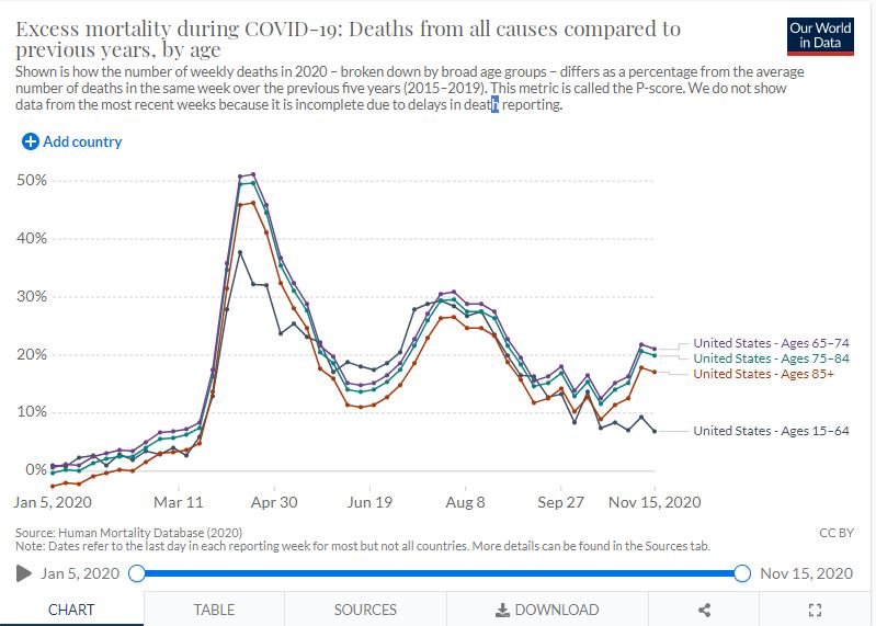
-
The composite over the next 10 days look like the bootleg -NAO you see in El Nino patterns where pac air invades the country with downstream ridging. Its why you don't see lower heights in the US underneath the "block."
-
Major LES event-December 24-27
OSUmetstud replied to BuffaloWeather's topic in Upstate New York/Pennsylvania
I hate the new radar gui. My God what shit. -
Major LES event-December 24-27
OSUmetstud replied to BuffaloWeather's topic in Upstate New York/Pennsylvania
My mom lives in West seneca on Kirkwood Dr. Im imagining they got it pretty good last night. -
Major LES event-December 24-27
OSUmetstud replied to BuffaloWeather's topic in Upstate New York/Pennsylvania
Im way more optimistic for the synoptic snow for BUF than I am the lake-effect. Weird lol. -
Major LES event-December 24-27
OSUmetstud replied to BuffaloWeather's topic in Upstate New York/Pennsylvania
I never seriously use NAM/RDPS out near 60-72 h. Mesomodels do screwy things with overall synoptic pattern as you go further out. It's just something to give pause. I'm not sure if it's right, but the ecmwf pattern is not good for lake effect for BUF and it's definitely a model I'd want in my camp if I wanted a significant event to unfold. The whole system is very convoluted. It's not a slam dunk. The upper level low is diving down in the OV/TN valley while a surface low is over Quebec. That evolution i think is causing some of the uncertainties. If you had a stacked low over Huron/south of James Bay we wouldn't be in a holding pattern right now. -
Major LES event-December 24-27
OSUmetstud replied to BuffaloWeather's topic in Upstate New York/Pennsylvania
Eh.. It's not great at depicting band strength. But the model literally has westerly flow at 850mb over the lake after the low departs Friday morning through Saturday. I wouldn't say that's exactly exciting if you like lake effect in BUF. -
Major LES event-December 24-27
OSUmetstud replied to BuffaloWeather's topic in Upstate New York/Pennsylvania
Yeah it's fine on a temporary basis (a few hours or something), but the idea that you're going to be getting 0.30"-0.50"/3 hr of freezing rain on the west side of the surface low is tough. If the precip were lighter/lift weaker then it would be easier to maintain the warm air aloft. -
Major LES event-December 24-27
OSUmetstud replied to BuffaloWeather's topic in Upstate New York/Pennsylvania
I don't buy the rdps/gdps with all that freezing rain west of the low center. They seem overzealous. It's really tough to drag in the low-level cold air while at the same time maintain a warm nose on the west side of a low. You'll have a tendency to go isothermal snow as lift increases. -
Major LES event-December 24-27
OSUmetstud replied to BuffaloWeather's topic in Upstate New York/Pennsylvania
All models are wrong, some give useful information. -
Major LES event-December 24-27
OSUmetstud replied to BuffaloWeather's topic in Upstate New York/Pennsylvania
That sounds right. 4-6"? -
Major LES event-December 24-27
OSUmetstud replied to BuffaloWeather's topic in Upstate New York/Pennsylvania
I think Saturday morning is the best chance for good LES in BUF now as some warm advection kicks on the tail end of the trough. At least with the synoptic low trending east, you end up getting more snow for Christmas morning. -
Major LES event-December 24-27
OSUmetstud replied to BuffaloWeather's topic in Upstate New York/Pennsylvania
I think the band starts Friday morning regardless of model qpf outputs. It's a bit sheared then for sure, but good enough for a moderate band of lake effect over the southern side of BUF. It gets better later in the day due to increased instability and less shear. -
Major LES event-December 24-27
OSUmetstud replied to BuffaloWeather's topic in Upstate New York/Pennsylvania
It doesnt look like a big lightning producer to me, maybe an odd strike or two. The inversion is close to 700mb which is fine for heavy snow in a cold airmass, but its not great for lightning as the -10c isotherm is so close to the ground. -
Major LES event-December 24-27
OSUmetstud replied to BuffaloWeather's topic in Upstate New York/Pennsylvania
The westward trends with the synoptic low are better for BUF, it increases the duration of southwesterlies on the backside. -
Pretty good.
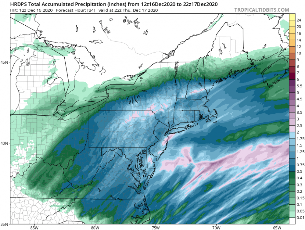
-
Mesos seemed better with this one in general.
-
Brutal
-
That's great. The early animal studies weren't clear that these vaccines were going to reduce transmission.
-
Active mid December with multiple event potential
OSUmetstud replied to Typhoon Tip's topic in New England
Yeah...I have another 18 degrees of longitude to work with... -
Active mid December with multiple event potential
OSUmetstud replied to Typhoon Tip's topic in New England
Given the trailing trough catching up to the low thats awfully close to a big one here. -
You mean antibody test? Antigen test is for current infection.
-
Active mid December with multiple event potential
OSUmetstud replied to Typhoon Tip's topic in New England
Coastal Labrador. It's a beast 50/50 windstorm, not a snowstorm here. -
Active mid December with multiple event potential
OSUmetstud replied to Typhoon Tip's topic in New England
Rain and wind? -
Active mid December with multiple event potential
OSUmetstud replied to Typhoon Tip's topic in New England
Idk, im hoping for further north solutions so that I get into some action Friday. Getting a SWFE now for 5 to 7 inches or so.