Tatamy
-
Posts
2,581 -
Joined
-
Last visited
Content Type
Profiles
Blogs
Forums
American Weather
Media Demo
Store
Gallery
Everything posted by Tatamy
-
 The Coastal Front is set up from the Richmond area to near Dover, DE to about 10 miles NW of Atlantic City and then up along and west of the Garden State Pkwy along the Jersey shore and just south of the south shore of LI. This is the leading edge of the warm air at the surface that the powerful 850mb jet is going to force up to the north and west and change everyone over to rain (if you don’t start as rain). In the case of the Poconos and the I84 corridor this would be sleet and freezing rain. This is situated as projected by the models at this time.
 -
Snowing in Reading, PA and the leading edge is just SW of Allentown. Snow is just beginning near the west side of Philadelphia.
-
I checked the webcam out there. Just the SC deck coming in off of the ocean. No flurries there at this time.
-
Was digging into the models and in looking at the HRRR from 12z it seems to be slightly less intense with the strength of the 850mb jet as compared to the NAM. The result is more snow in inland locations. The NAM has 1-2” vs 3-6” on the HRRR. Any thoughts on this?
-
How about Hurricane Force Wind Watches for the near shore and offshore waters as well.
-
Very true. The upside of this is that this won’t last over multiple tidal cycles. If it did it would be a much more serious issue. For coastal areas I think that the biggest concern will be strong winds leading to power outages.
-
My rule of thumb has been if we are dealing with a potential winter storm that you think can bring mixing / taint issues then you want to see a mid level jet from a warm source region of at least 20 - 30 mph to ensure that changeover happens. I will be the first to admit that this is a general statement and is oversimplifying the atmospheric processes involved however I seen this play out time and again. In any case the 850mb jet we are seeing will be from the SE at up to 90 mph for a few hours Monday morning.
-
I saw that graphic a short time ago as well. Folks in the western part of the state have been progged to get a big dumping on the models and still are on the globals. The NAM doesn’t play favorites does it??
-
I am in eastern PA, 80 miles west of NYC. I am figuring on 2-3 hours of snow then a quick flip to sleet/ice/rain in that order. That 850mb jet means business and the NAM / RGEM seems to be leading the way with this feature. As depicted that jet will be whistling over our heads at Cat 2 hurricane strength early Monday morning. The source region will be from out over the Atlantic so it won’t be bringing cold air with it either.
-
I was thinking of the ski resort at Hunter Mtn. which is much higher. KMPO where the airport observing site is at 1886ft (from the Mt. Holly website). The town itself is a couple of hundred feet lower.
-
If there is an upside here the forward movement of the storm system is such that it is not likely to cause flooding through multiple tidal cycles.
-
Your caution is well advised however the poster did not want to travel more than 100 miles from the NYC area. As others have noted this one definitely has the look of being mainly a snow producer for areas in central and western PA and NY state.
-
The 18z Euro has run. The overall presentation of expected snow amounts is similar however the 850mb low does track very slightly further west on this run.
-
I would take Hunter over MPO in a heartbeat. Hunter is close to 4000’ above MSL while MPO is 2000’. Track will be key of course.
-
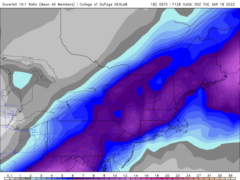
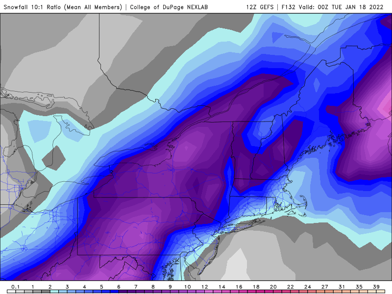
The top map with the higher amounts to the north was from the College of Dupage website. On their website they state that the data presented is downloaded directly from the NCEI servers. It uses a 10:1 ratio to calculate snow amounts. We all know that these clown maps have their limitations and that actual ratios that occur will vary from place to place. WRT to SV I will leave that up to you to determine the validity of the data presented.
-
What is most interesting is how the model is struggling to resolve the UVVs that are taking place across eastern PA and NW NJ in the area of heaviest precip. Very dynamic system.
-
Precip type with this one will have to do with temperatures at all levels of the atmosphere, not just 850mb. If you picked up somewhere that temperatures at or below 0 at 850mb means that you are golden for snow - you are badly mistaken. There will be CAD inland initially with this storm and that means that precip that starts as snow will go to sleet and or ice before going to rain in many places. As currently modeled the coast will be primarily rain (as of now). As we all know the forecasts for this storm have been subject to big changes with each model run. To determine precip type for your location you would need to check a sounding for your specific location.
-
12z GFS at 117 hrs. Again this would result in tropical storm force winds along coastal areas. Period of highest risk would be Monday.
-
12z Euro at 120 hrs. If this verifies you will have tropical storm force winds along the Jersey shore, NY harbor, and along the south shore of LI.
-
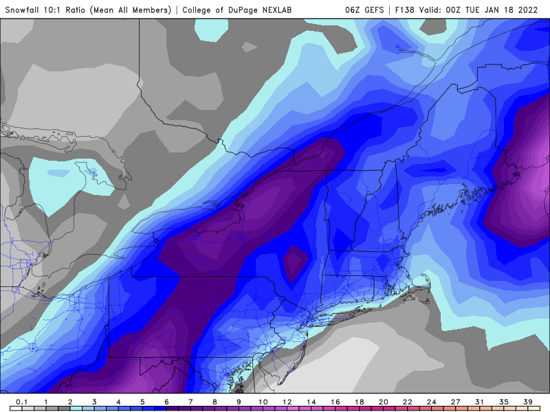
Here is the ensemble mean snowfall (GEFS) estimates for this system for 6z and 12z. 6z 12z
-
Go to the state that you are interested in and lookup the DOT website for it. It will provide a link to highway webcams on the major roads.
-
I my original post I was referring to areas well inland away from the coast. As modeled there is a fair amount of sleet and freezing rain associated with this storm in those places. Strongly agree that the strong easterly or SE flow will kill chances for freezing/frozen precip near the coast.