Tatamy
-
Posts
2,573 -
Joined
-
Last visited
Content Type
Profiles
Blogs
Forums
American Weather
Media Demo
Store
Gallery
Everything posted by Tatamy
-
There is a line of rapidly growing towering CU across eastern PA and NW NJ. These will be producing increased coverage of showers/storms shortly.
-
Just passed through here. Some wind and rain but nothing too out of the ordinary with some rumbles of thunder.
-
I experienced a very impressive storm in Brooklyn on the Belt Pkwy while driving earlier. Besides strong winds, lightning , and torrential rains I went through a small intense hail core near Ocean Pkwy. This was big hail with stones up to one inch in diameter. I was in stop and go traffic at the time so I could not take photos. I honestly thought my windshield would be taken out! Flooding from this storm produced flooding on the Belt that blocked two lanes near Cropsey Ave. Time of this was about 6:45 PM
-

E PA/NJ/DE Spring 2026 Obs/Discussion
Tatamy replied to PhiEaglesfan712's topic in Philadelphia Region
I saw exactly what you did. It’s not common and there is already reports on social media of power outages. It relates to where these downbursts occurred. -
E PA/NJ/DE Spring 2026 Obs/Discussion
Tatamy replied to PhiEaglesfan712's topic in Philadelphia Region
I am observing power flashes with this line just west and SW of me near Bethlehem. This is not lightning. -
Reached 82 here. Liking this May in March weather.
-
2/24 - 2/25 Clipper Obs (1 - 2" for many on forum)
Tatamy replied to Northof78's topic in New York City Metro
1/4” new -
Storm total here in Bethlehem Twp. is 5.3”
-
Now up to 4” new in Bethlehem Twp. 30/29
-
Measured 2” new in Bethlehem Twp. 30/29z
-
1” new. 30/29. Moderate snow.
-
Moderate snow - Visibility 1/2 mile. 32/31
-
They’re in a tough spot as the models have been all over the place. They use the NBM which is a weighted model containing most all of the other models outputs ( It’s like a mean of the other model projections). Because of how it works there is a delay in terms of it not recognizing the newest data. Incidentally your number seems reasonable to me.
-
I’m observing that as well. My temp has also dropped to 35.
-
I’m trying to that with that heavier band near Trenton that is struggling to move NW. Not working out too good.
-
Same here.
-
You’re in a better place. Enjoy!
-
Light rain 36/33
-
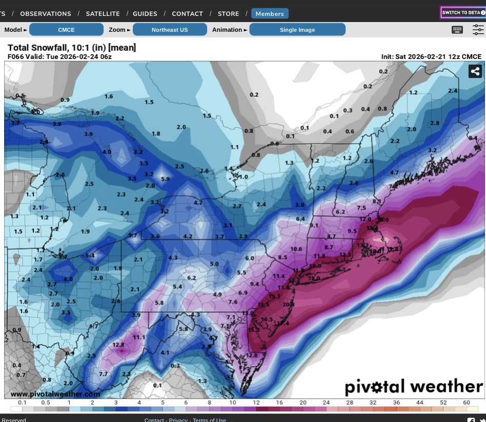
12z HRRR concurs with the Delaware River cutoff for the big snows.
-
Steady light snow. Visibility 3 miles. 33/31
-
It’s an interesting forecast where I am near the Delaware River with only the short term Mesos calling for big snows here (12-18”) whereas the globals and some mesos are calling for 8-12”. The IVT will be the key out here for me and other NW areas. The cutoff will be right through my general area I believe.
-
Regarding the output from the RDPS, it’s similar to the run at 12z. This is the CMC ensemble run from 12z. If someone can explain the difference between these I would be interested to know.

-
Orographic lift
-
I own one on Fire Island.
-
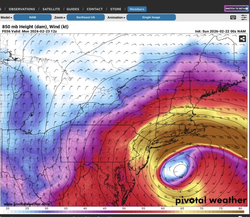
This might be part of the answer. Check out this 850 mb jet.