

powderfreak
-
Posts
83,664 -
Joined
-
Last visited
Content Type
Profiles
Blogs
Forums
American Weather
Media Demo
Store
Gallery
Everything posted by powderfreak
-
I honestly think if MSM polled the public they would say it snows year round in the northern Rockies peaks.
-
When it snows above 2,000ft even in New England (anytime of year), no one really cares lol. Above 8,000ft in the Bitterroot Mtns isn’t going to move the public interest needle much.
-
Ha, 11 members and 9K guests.
-
Webbed hands of Stein have reached the server room.
-
This thing is full struggle bus today.
-
Joe Bastardi got rich off that with snowstorms and winter weather fans in the late 1990s and 2000s.
-
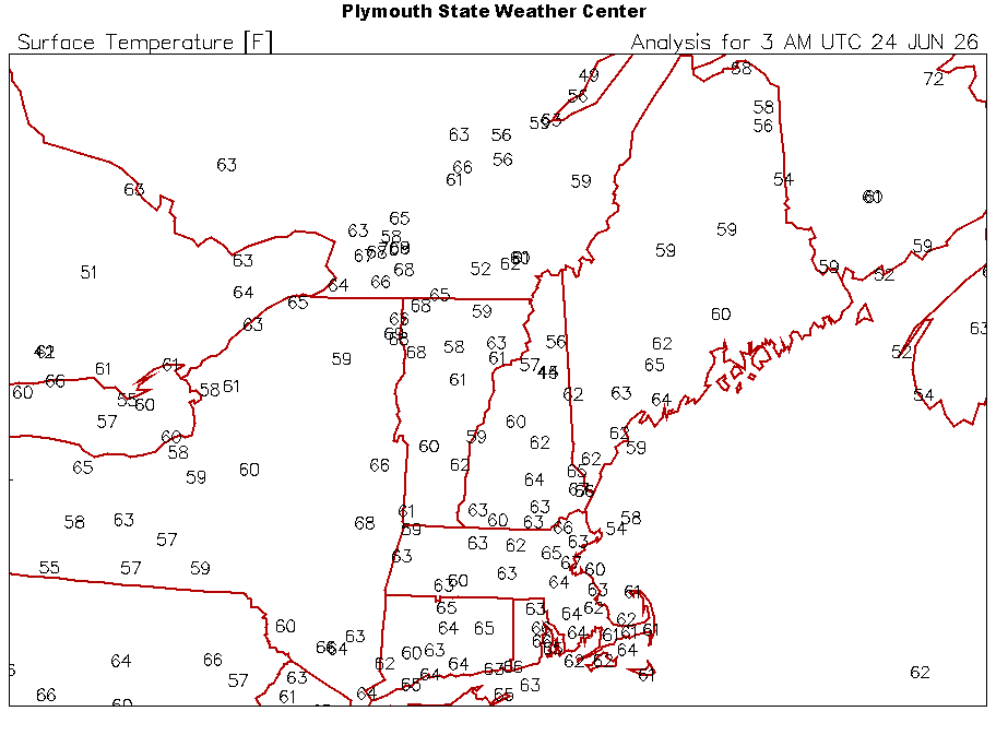
58F, the mountain valleys always have the biggest ranges. Hottest then the coolest.
-
Nice 1.20” for event? That’ll soak.
-
Absolutely, sorry if that came off as having a “winner” or “loser”. It’s a discussion board, so it was a little funny that after 6 paragraphs about the overuse of “heat dome”, that Tip writes a one liner about a massive heat dome in the long range. Hopefully we can see a little of the humor in that sequence of posts.
-
0.19” today. Enough to wet the ground.
-
This is awesome footage dude… catching that on a game cam, love to see it.
-
Absolutely pouring. I thought the rain shield was down south and wondering why we are getting soaked. Can’t miss right now.
-
Need an AI version with Stein dancing in that video instead of MJ.
-
Your pad always looks absolutely dialed, very aesthetically pleasing summer scene.
-
Every day. Thunder and heavy rain. May only be a quarter inch but will gladly send it to someone who wants it. It better not rain tomorrow.
-
Well played, Tip .
-
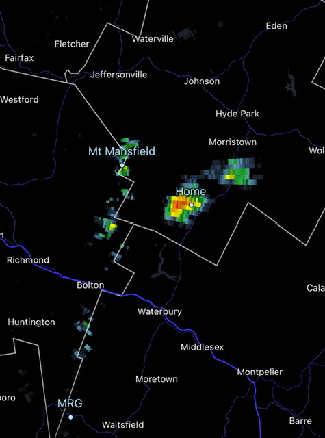
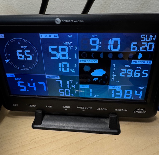
Over 3.5” past three days. I see J.Spin is over 4.5”. Mushrooms growing in the yard. Mountain Operations station for Mansfield showing 5.47”… about 2” more than town, which fits with orographics and NW flow.
-
It has been pouring this morning. Just doesn’t stop. PWS are 0.4-0.5” since midnight.
-
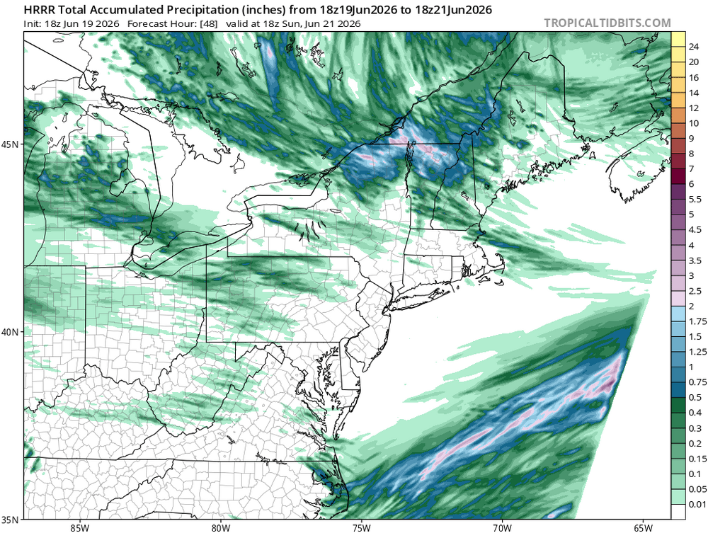
Another 0.5-1.0” around the area today. 0.78” here. Looks like the I-89 corridor south of here saw the more consistent 1” totals. The heavier initial convergence band has slinked south, but there’s moisture stacked to Hudson Bay that’s going to be advected south into the NW slopes of the Appalachian chain all weekend. Can’t catch a break on these weekends.
-
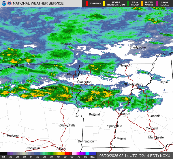
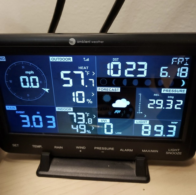
Yeah, I’ll be honest, when I looked at Cocorahs last night, it didn’t have yesterday’s rainfall added in. I hadn’t looked yet today but I’m sure another 1-2” was added everywhere up north. Up at Mansfield, our Mtn Operations station showed 3.03” from this recent “event.”
-
That’s crazy, must’ve been localized. Looked on Cocorahs and most stations seemed similar 3-5” this month. Can’t imagine being at 8”+ lol. Now see those Bretton Woods stations at 7-9”, that’s wild. Beavers or not, that’s gotta be near flash flood in some of those inches.
-
Wish we were there. Winter-like NW flow cyclonic pattern at the solstice. Doesn’t get much shittier.
-
Make the rain stop. If we have to do this showery downpour crap all weekend… not a fan.
-
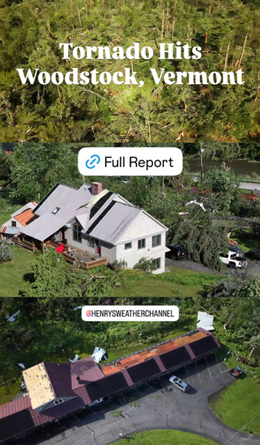
Seems like Woodstock, VT saw a legit EF1 or EF2 tornado based on the photos and drone images. Enough to peel some roofing off and level trees.
-
Wait what?! 3-5” around here.


