powderfreak
-
Posts
83,761 -
Joined
-
Last visited
Content Type
Profiles
Blogs
Forums
American Weather
Media Demo
Store
Gallery
Everything posted by powderfreak
-

Hoisting the Sultan Signal: Heavy Rain Event July 5-7
powderfreak replied to WxWatcher007's topic in New England
Another sunny day and 81F. Hasn’t rained in days. Feels like a different planet from SNE. -
Hoisting the Sultan Signal: Heavy Rain Event July 5-7
powderfreak replied to WxWatcher007's topic in New England
Yeah, sounds like it. That’s the classic upslope rains… just soaking sheet small droplets and seem to add up faster than it should. Radar over you has been steady but also hasn’t looked like 1”+. That’s why I was surprised. -
Hoisting the Sultan Signal: Heavy Rain Event July 5-7
powderfreak replied to WxWatcher007's topic in New England
Congrats on nearly 3”… everyone wins. -
Hoisting the Sultan Signal: Heavy Rain Event July 5-7
powderfreak replied to WxWatcher007's topic in New England
Huh, look at that. Some knew, some didn’t. -
Hoisting the Sultan Signal: Heavy Rain Event July 5-7
powderfreak replied to WxWatcher007's topic in New England
DIT is over an inch since midnight?! -
Hoisting the Sultan Signal: Heavy Rain Event July 5-7
powderfreak replied to WxWatcher007's topic in New England
Wait for it to blossom like the U.S. team. Tied. Edit: Shit, 30 seconds later Belgium punched back. -
Hoisting the Sultan Signal: Heavy Rain Event July 5-7
powderfreak replied to WxWatcher007's topic in New England
Ok yeah I was thinking another half inch possible, but models are all over the place. It does look like that stuff in SW CT tries to lift through tonight but in a diminished capacity. -
Hoisting the Sultan Signal: Heavy Rain Event July 5-7
powderfreak replied to WxWatcher007's topic in New England
So you won’t record any more rain… what’s your final total then? -
Hoisting the Sultan Signal: Heavy Rain Event July 5-7
powderfreak replied to WxWatcher007's topic in New England
How much you have so far? Before the stuff tomorrow morning. -
Hoisting the Sultan Signal: Heavy Rain Event July 5-7
powderfreak replied to WxWatcher007's topic in New England
83F and sunny up here. Summer. -
Hoisting the Sultan Signal: Heavy Rain Event July 5-7
powderfreak replied to WxWatcher007's topic in New England
6am tomorrow… long way to go.
-
Hoisting the Sultan Signal: Heavy Rain Event July 5-7
powderfreak replied to WxWatcher007's topic in New England
Who is this DIT?! -
82/48 today, with a breeze. Perfect summer weather. AC not needed on these days.
-
Hoisting the Sultan Signal: Heavy Rain Event July 5-7
powderfreak replied to WxWatcher007's topic in New England
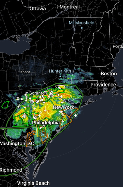
It’s like one big thunderstorm. Lightning across three states.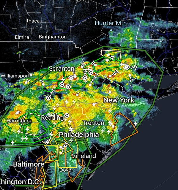
-
Hoisting the Sultan Signal: Heavy Rain Event July 5-7
powderfreak replied to WxWatcher007's topic in New England
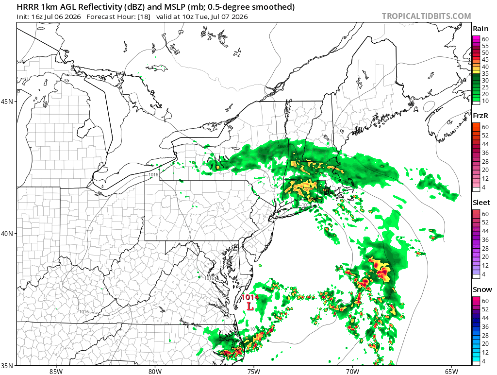
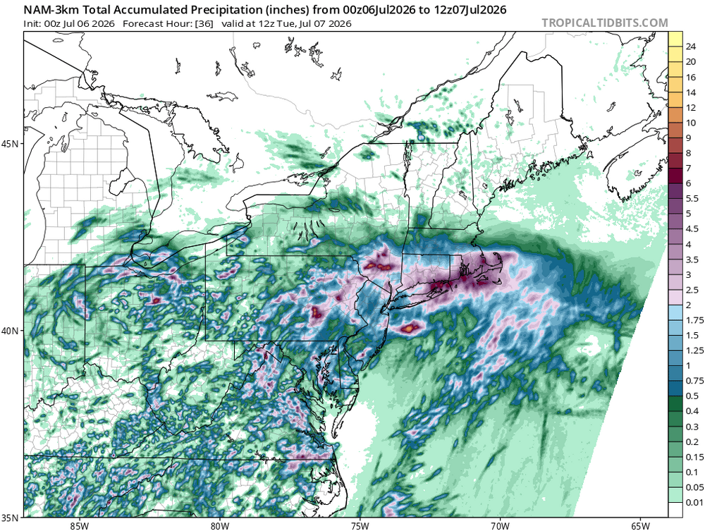
South coast smoked on NAM and HRRR.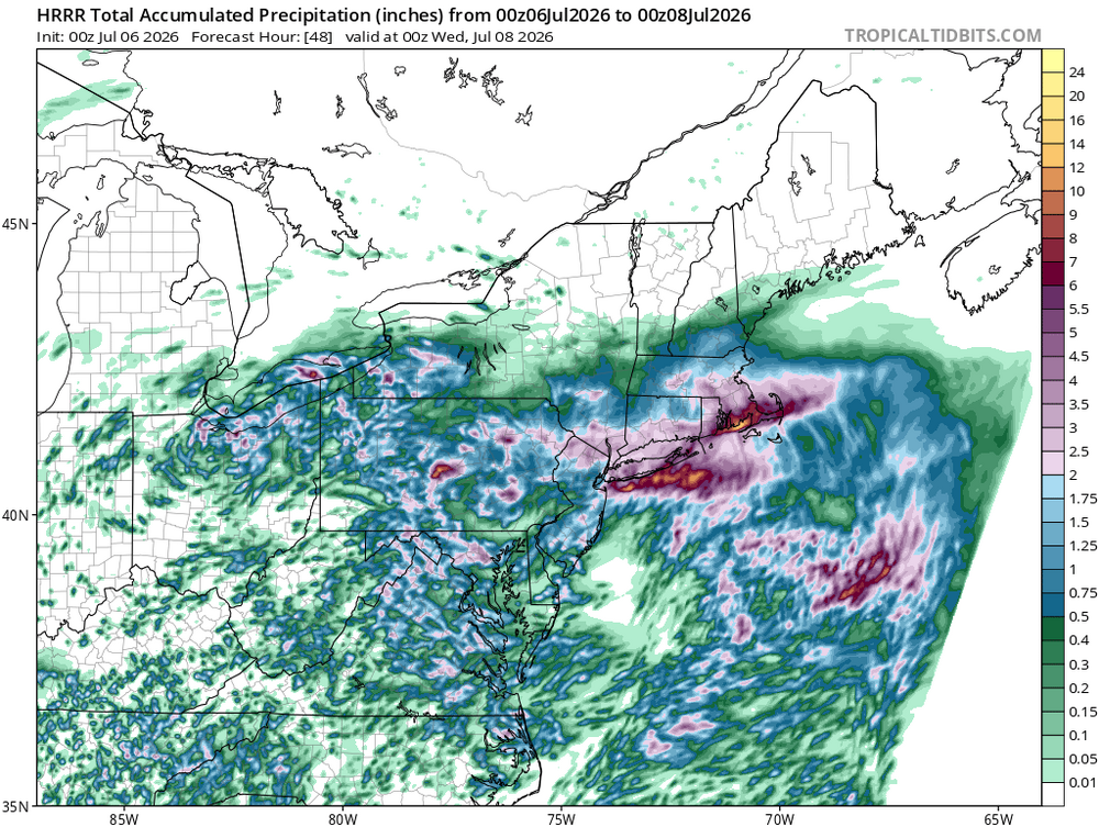
-
That’s a very honest answer, ha. I feel that. These events are always going to have surprises when convection is involved. My one pause is always the consistent bullseye for days… nothing is ever that consistent this time of year. There’s always the haves and have nots… one town gets 0.92” in three rounds of 0.30” rain. While another town does 3.28” not far away.
-
How far would you toss the extended HRRR if this were winter?
-
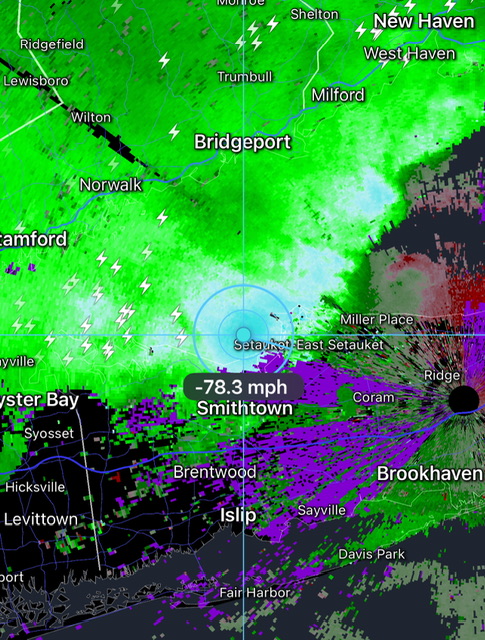
Good wind crossing the Sound. This is close to the radar site, so the radar sample is low elevation. That wind is likely legit for those in its path.
-
Someone is getting destroyed by flash flooding. It won’t be that widespread, but that signal means damage.
-
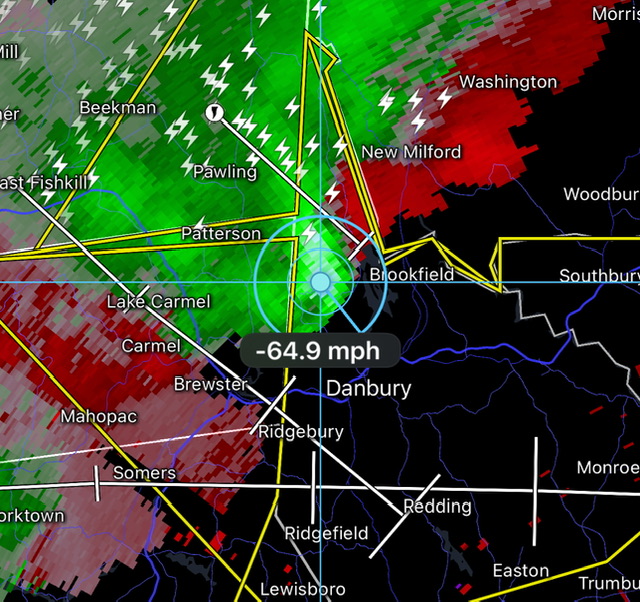
That’s legit. That hail has to be pushing 2”.
-
There’s 65-70 DBZ scanned south of New Britain. That’s intense. OKX radar sampling that at 3,800ft elevation it looks like.
-
Decent wind velocities.
-
76/54 Dried out nicely this afternoon. Open the windows up.
-
ICON has like a foot for NYC, ha.
-
I’d feel fairly confident in 1”+ for your location… but yeah, I guess like winter if folks are looking for jackpots those will be narrow. Someone gets 1.5”, they’ll say they were Steined because somewhere else saw 4.5” and flash flooding.