powderfreak
-
Posts
83,813 -
Joined
-
Last visited
Content Type
Profiles
Blogs
Forums
American Weather
Media Demo
Store
Gallery
Everything posted by powderfreak
-
 Heavy rain now but oddly no lightning or thunder that I can see/hear.
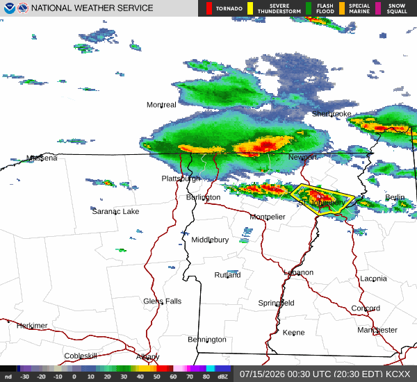
-
Yeah he’s the dude up here for on camera Mets.
-
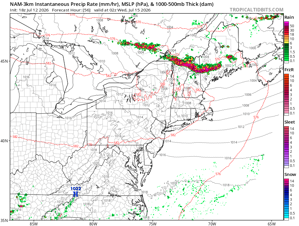
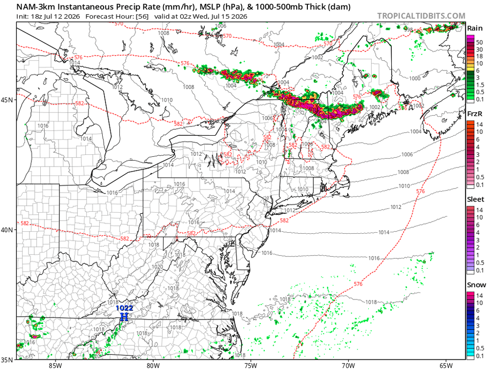
Didn’t all the CAMs show more activity in Maine than has happened? It’s ok if it “busts”, no one saw the smoke coming. This has been a pretty hyped day, to the point that people who don’t follow weather have been talking about it up here. We were supposed to be like 90F today and instead low-80s. That has to matter. Our time in VT has always been like 9p-1a though… but like Tyler in the post, I thought Maine would’ve been lit up already.
-
It was interesting to see the sky go blue suddenly, temp skyrocketed, but now back in the smoke and temp down again.
-
End of times yellow glow around here from the smoke.
-
Nothing ever like that winter in recorded history up here. It was an experience for sure to try and operate a ski area through that. We even started up our summer activities that holiday period, like high ropes course, climbing walls, zip lines and stuff, to give all the hotel guests at least some activities.
-
I’d have to look it up… but nothing is sticking out in a memorable way. Looking at the snow depth there was a decent gain in the first half of December that plateaued for a while before a Xmas thaw hit. Snow depth looks pretty normal in Dec 2014.
-
Christmas Day 2015 baby. Only time in 70 years without a trace of snow at the CO-OP stake. Not even ice on the cliffs. Had a couple nights cold enough to blow a white ribbon, ha.
-
Feels like we do that anyway these days, Nino or not.
-
That October 2011 event makes you remember when "snow maps" were still a new thing, and Met offices didn't know how to use them exactly, especially in the shoulder seasons. "Dumb guy snow output" ended up being too low. HWO THERE IS A CHANCE OF A MODERATE TO HEAVY ACCUMULATING SNOWFALL ON SATURDAY. IF CONFIDENCE INCREASES...THEN A WINTER STORM WATCH. WILL BE ISSUED LATER TODAY From AFD THE GFS DUMB GUY SNOW OUTPUT IS 1-4 INCHES NORTH...10-15 IN HIGHER TRRN OF VT/MA/NY AND 6-8 ON VLY FLOORS. YES THESE ARE WINTER EQ AND THURSDAYS EVENT IT WAS ADVERTISING 4-8 INCHES AND MOST AREAS SAW 1-3. ITS NAM COUNTER PART IS MUCH FURTHER SOUTH...WITH 1-2 IN CATSKILLS AND 8 IN LITCHFIELD
-
That’s a solid line sagging south.
-
Yeah, as long as it’s warm enough inside not to freeze pipes… cooler weather is definitely an easier time to lose power. Especially after an October snowstorm because it won’t be deep cold afterwards. Just cold enough to put perishables outside in the snow.
-
Ha, I do remember you being stoked somehow the entire time.
-
To be fair, DIT lost power for like a week in the October 2011 snowstorm and not once do I remember him complaining about it, ha.
-
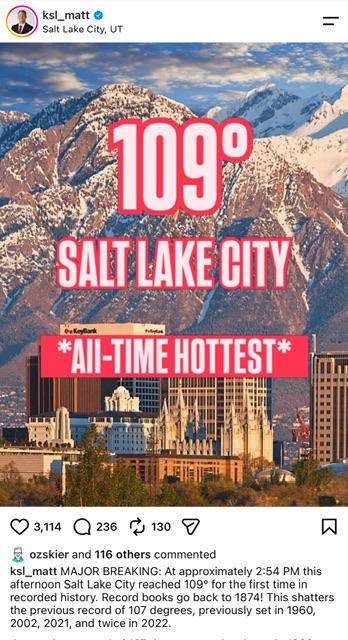
Figured @vortex95 would appreciate this SLC met using a photo of snowy mountains for the all-time hottest temperature since 1874… could’ve gone with flames and death, instead a tranquil April day photo of the Wasatch, lol.
-
I’d take it.
-
Nice day for business suits. Up to 75F already from a low of 48F.
-
Feels like that wouldn’t even satisfy folks, as soon as the GFS shows a dry 7 days it’d be like a week of rain never happened.
-
Sounds like you need to go above 7,500ft…. Get as high as possible.
-
Only a half inch over this way. Seemed to get a bunch of 7-10 splits until finally catching a core. Sharp gradient… only a couple miles south showing 1-1.5”… only a couple miles north under <0.25” like at the ASOS.
-
Took 24 hours lol.
-
Dangerously. Unprecedented.
-
This. We can blame hype but the amount of video easily available now is something never seen before. It’s the same with any outrageous behavior captured on film. There have always been Karens… since the dawn of time… but now you see video of every single person doing something obnoxious or dumb. Dumb people making bad decisions have always existed, too. You just never saw it. I don’t think people understand the gravity and how our perception has changed on certain things since every human holds an HD camera in their pocket.
-
Add politics to that, probably more so than sports and weather. People do like to be entertained though.
-
Hoisting the Sultan Signal: Heavy Rain Event July 5-7
powderfreak replied to WxWatcher007's topic in New England
You got 3 weeks of rain in a day. How much do you all want to “make a dent”? Honest question.