nj2va
-
Posts
15,205 -
Joined
-
Last visited
Content Type
Profiles
Blogs
Forums
American Weather
Media Demo
Store
Gallery
Everything posted by nj2va
-

January 24-26: Miracle or Mirage JV/Banter Thread!
nj2va replied to SnowenOutThere's topic in Mid Atlantic
Oh yea, I forgot you’re at 3,000’ up there -
Even the most amped models are getting warning level+ snowfall to NVA/DC/etc before any kind of flip happens. That’s a great thing.
-
January 24-26: Miracle or Mirage JV/Banter Thread!
nj2va replied to SnowenOutThere's topic in Mid Atlantic
Didn’t you know we live on Tug hill -
NW DC barely hanging on 18z Sunday with sleet criss crossing the city. But by then 0.9” of QPF has fallen so an impressive thump, better than 18z.
-
Looks like late Saturday night start on ICON.
-
January 24-26: Miracle or Mirage JV/Banter Thread!
nj2va replied to SnowenOutThere's topic in Mid Atlantic
Let’s go Caps! -
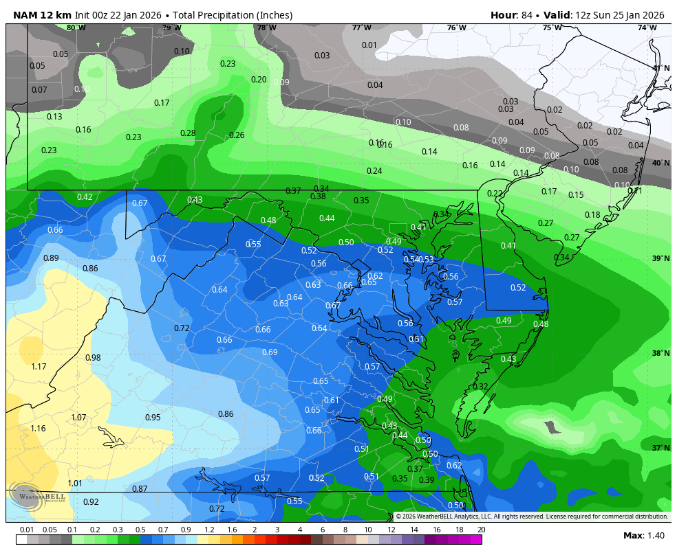
One thing on the NAM - from H81 to H84, DC gets ~0.35” QPF, all snow. 1”+/hour rates…would be fun, with more to come.
-
No, GFS and Euro I believe
-
This is all snow north of about Henrico county ish

-
Looks like its transferring off Wilmington, NC at H84?

-
January 24-26: Miracle or Mirage JV/Banter Thread!
nj2va replied to SnowenOutThere's topic in Mid Atlantic
I’m having a margarita in honor of our Baja low. -
The NS at H51 is also a bit west of 18z so I wonder if they offset. I have no clue what to look for as others have stated.
-
January 24-26: Miracle or Mirage JV/Banter Thread!
nj2va replied to SnowenOutThere's topic in Mid Atlantic
Ingesting so much data for winter storm fern
-
January 24-26: Miracle or Mirage JV/Banter Thread!
nj2va replied to SnowenOutThere's topic in Mid Atlantic
Remarkable how slow the NAM comes out -
January 24-26: Miracle or Mirage JV/Banter Thread!
nj2va replied to SnowenOutThere's topic in Mid Atlantic
“Oh yeah, that guys a tool” -
January 24-26: Miracle or Mirage JV/Banter Thread!
nj2va replied to SnowenOutThere's topic in Mid Atlantic
Maybe I'm the only one who would be happy to get 4-6" of snow with a glacier of sleet/ice on top of it. -
You'd think that would result in a less amped storm with those changes at 500.
-
January 24-26: Miracle or Mirage JV/Banter Thread!
nj2va replied to SnowenOutThere's topic in Mid Atlantic
Looking fwd to it! -
January 24-26: Miracle or Mirage JV/Banter Thread!
nj2va replied to SnowenOutThere's topic in Mid Atlantic
Can you keep this in banter? no one should be cliff diving FFS -
January 24-26: Miracle or Mirage JV/Banter Thread!
nj2va replied to SnowenOutThere's topic in Mid Atlantic
Man, been in meetings / away from my desk most of the day but skimmed the old thread to get caught up. Seems like we're locked and loaded! -
On the bus heading into the office now. People next to me chatting excitedly about the snow. Should I tell them it’s going to be sleet instead?
-
We’re under 100 hours from first flakes.
-
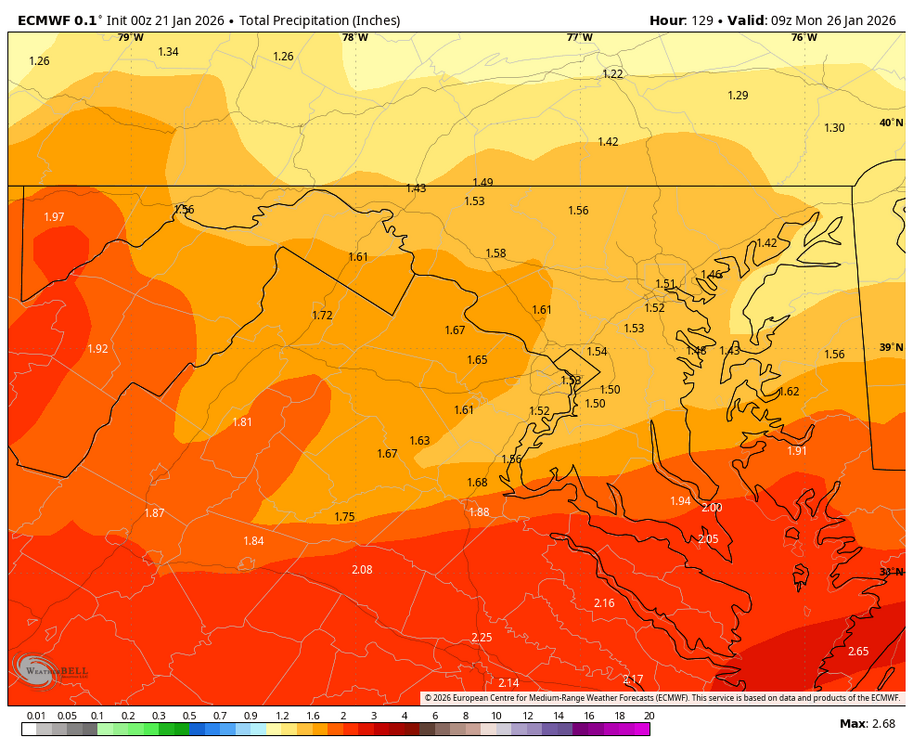
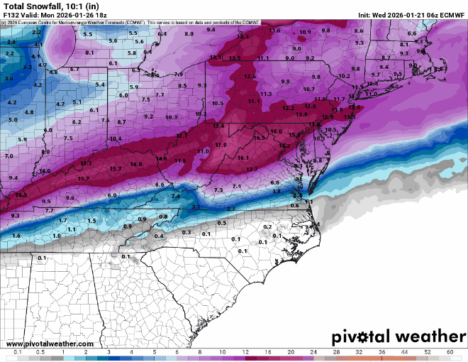
Here’s WXBell total. That front end thump is hawt
-
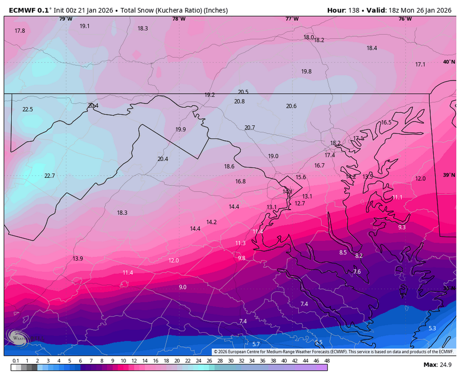
Kuchie is over a foot in DC before the changeover. More N/W.
-
RIC is over 2” of QPF storm total. DC 1.5”