(002).png.f2cbd7c955dc3007a02ab79925b174ec.png)
ChescoWx
-
Posts
11,175 -
Joined
-
Last visited
Content Type
Profiles
Blogs
Forums
American Weather
Media Demo
Store
Gallery
Everything posted by ChescoWx
-
(002).thumb.png.6e3d9d46bca5fe41aab7a74871dd8af8.png)
Central PA Spring 2026 Discussion/Obs Thread
ChescoWx replied to Voyager's topic in Upstate New York/Pennsylvania
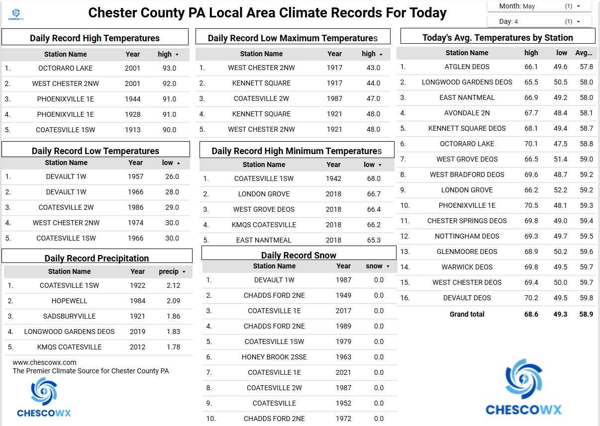
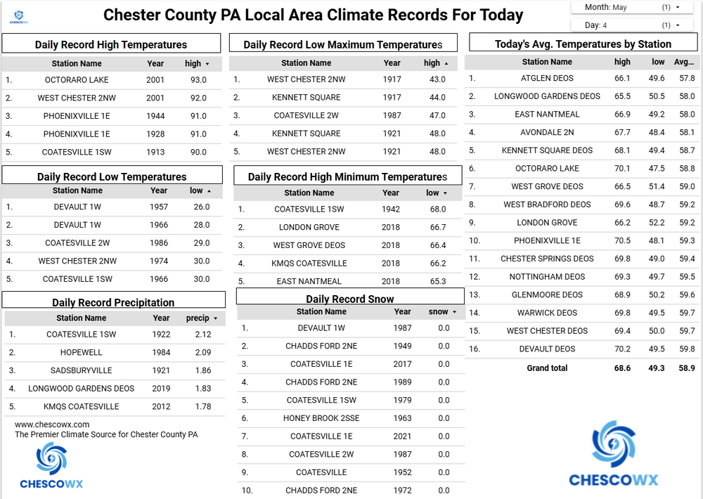
I actually did just such a deep dive into for example the NWS COOP station at Coatesville 1SW below shows any bias would only have potentially been present from 1910-1921. So not significant based on the 89 years of history for that station.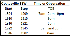
-
E PA/NJ/DE Spring 2026 Obs/Discussion
ChescoWx replied to PhiEaglesfan712's topic in Philadelphia Region
If modeling is correct certainly no long lasting warmth through June at least -
I have compiled the climate averages based on the NOAA calculation of Climate Normals for the philly burbs of Chester County PA for a full year with 30 year averages updated every 10 years. The first base period was from 1901-1930 with our most recent being the current climate base of 1991-2020. You can see our warmest base climate normal occurred back in the 1921-1950 and 1931-1960 periods.
-
Central PA Spring 2026 Discussion/Obs Thread
ChescoWx replied to Voyager's topic in Upstate New York/Pennsylvania
I have compiled the climate averages based on the NOAA calculation of Climate Normals for the philly burbs of Chester County PA for a full year with 30 year averages updated every 10 years. The first base period was from 1901-1930 with our most recent being the current climate base of 1991-2020. You can see our warmest base climate normal occurred back in the 1921-1950 and 1931-1960 periods.
-
E PA/NJ/DE Spring 2026 Obs/Discussion
ChescoWx replied to PhiEaglesfan712's topic in Philadelphia Region
I have compiled the climate averages based on the NOAA calculation of Climate Normals for the philly burbs of Chester County PA for a full year with 30 year averages updated every 10 years. The first base period was from 1901-1930 with our most recent being the current climate base of 1991-2020. You can see our warmest base climate normal occurred back in the 1921-1950 and 1931-1960 periods.
-
Central PA Spring 2026 Discussion/Obs Thread
ChescoWx replied to Voyager's topic in Upstate New York/Pennsylvania
Mostly cloudy today with highs not too far from average near 70 degrees. Some rain showers and maybe a thunderstorm late tonight ending toward rush hour tomorrow. We fall back to below normal temperatures both tomorrow and Friday before a big warm up with temperatures across the county reaching around 80 degrees on Saturday and the mid to upper 80’s on Sunday and Monday. Next Tuesday should be the hottest day with temperatures especially in lower valley locations possibly touching 90 degrees. We will get cooler again by the middle of next week.
-
E PA/NJ/DE Spring 2026 Obs/Discussion
ChescoWx replied to PhiEaglesfan712's topic in Philadelphia Region
Mostly cloudy today with highs not too far from average near 70 degrees. Some rain showers and maybe a thunderstorm late tonight ending toward rush hour tomorrow. We fall back to below normal temperatures both tomorrow and Friday before a big warm up with temperatures across the county reaching around 80 degrees on Saturday and the mid to upper 80’s on Sunday and Monday. Next Tuesday should be the hottest day with temperatures especially in lower valley locations possibly touching 90 degrees. We will get cooler again by the middle of next week.
-
Central PA Spring 2026 Discussion/Obs Thread
ChescoWx replied to Voyager's topic in Upstate New York/Pennsylvania
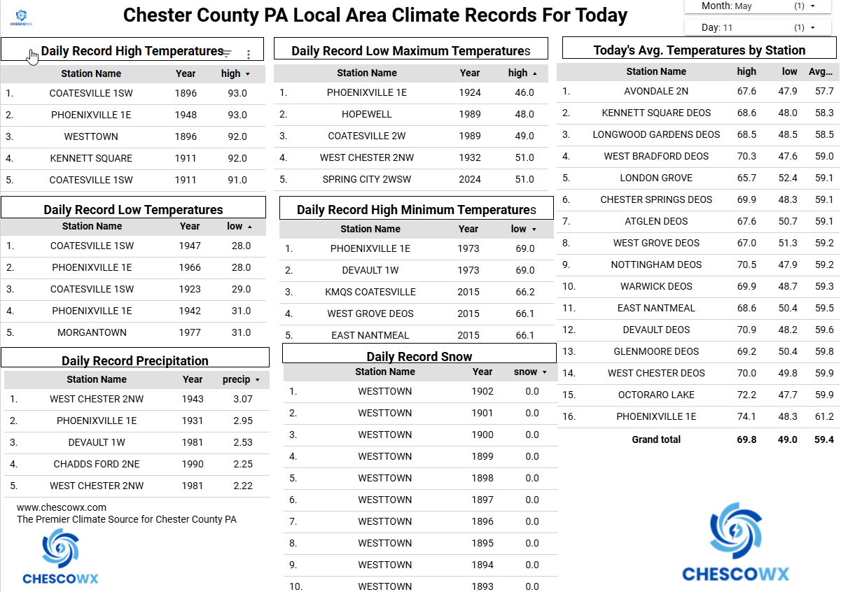
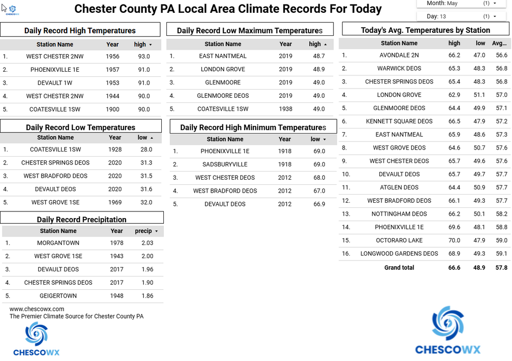
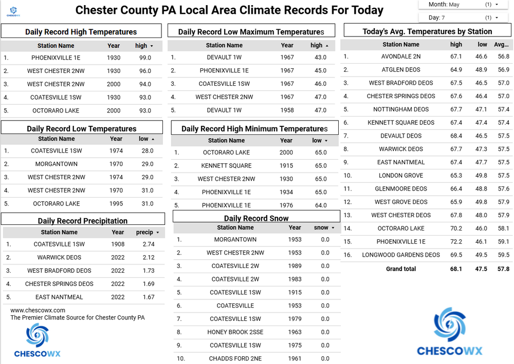
Widespread lows were in the 30’s overnight with some valley locations near or below freezing this morning. The lowest reading was the 31.5 at Warwick Township. That is tied for the 2nd coldest reading for today’s date across Chester County behind only the 31-degree low recorded at Coatesville in 1907 and Morgantown in 1963, That may well be our last freezing observation across the county until October. We continue with below normal temperatures through the rest of the work week before we warm up to well above normal temperatures starting Saturday and into next week. Rain chances increase by tomorrow night into Thursday morning.
-
E PA/NJ/DE Spring 2026 Obs/Discussion
ChescoWx replied to PhiEaglesfan712's topic in Philadelphia Region
Widespread lows were in the 30’s overnight with some valley locations near or below freezing this morning. The lowest reading was the 31.5 at Warwick Township. That is tied for the 2nd coldest reading for today’s date across Chester County behind only the 31-degree low recorded at Coatesville in 1907 and Morgantown in 1963, That may well be our last freezing observation across the county until October. We continue with below normal temperatures through the rest of the work week before we warm up to well above normal temperatures starting Saturday and into next week. Rain chances increase by tomorrow night into Thursday morning.
-
Central PA Spring 2026 Discussion/Obs Thread
ChescoWx replied to Voyager's topic in Upstate New York/Pennsylvania
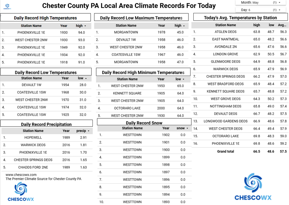
We have received measurable rain in 5 of the last 6 days across the county. Below normal temperatures are likely to continue today through Friday before we warm back to above normal by the weekend. The best chances of rain will be Wednesday into Thursday morning.

-
E PA/NJ/DE Spring 2026 Obs/Discussion
ChescoWx replied to PhiEaglesfan712's topic in Philadelphia Region
We have received measurable rain in 5 of the last 6 days across the county. Below normal temperatures are likely to continue today through Friday before we warm back to above normal by the weekend. The best chances of rain will be Wednesday into Thursday morning.
-
Central PA Spring 2026 Discussion/Obs Thread
ChescoWx replied to Voyager's topic in Upstate New York/Pennsylvania
Happy Mother's Day to all of the moms out there! We should see a great weather day for all of you with highs in the mid 70's. There could be some showers developing late in the afternoon and into the evening. Back to cooler than normal temperatures the rest of the upcoming work week before we warm up by next weekend. Our best rain chances after later today will be Wednesday into Thursday.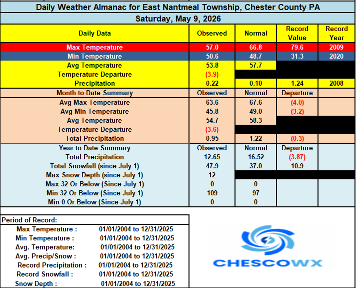
-
E PA/NJ/DE Spring 2026 Obs/Discussion
ChescoWx replied to PhiEaglesfan712's topic in Philadelphia Region
Happy Mother's Day to all of the moms out there! We should see a great weather day for all of you with highs in the mid 70's. There could be some showers developing late in the afternoon and into the evening. Back to cooler than normal temperatures the rest of the upcoming work week before we warm up by next weekend. Our best rain chances after later today will be Wednesday into Thursday.
-
Central PA Spring 2026 Discussion/Obs Thread
ChescoWx replied to Voyager's topic in Upstate New York/Pennsylvania
We have some light rain around this morning here in NW Chester County a cool day is on tap with some showers. Highs will struggle to reach the lower 60's. Nice but brief warm up tomorrow for Mom's Day with highs reaching the mid 70's with sunshine. Much cooler again with below normal temperatures all week. We will have additional rain chances both Sunday night and Monday and again Wednesday through Friday.

-
E PA/NJ/DE Spring 2026 Obs/Discussion
ChescoWx replied to PhiEaglesfan712's topic in Philadelphia Region
We have some light rain around this morning here in NW Chester County a cool day is on tap with some showers. Highs will struggle to reach the lower 60's. Nice but brief warm up tomorrow for Mom's Day with highs reaching the mid 70's with sunshine. Much cooler again with below normal temperatures all week. We will have additional rain chances both Sunday night and Monday and again Wednesday through Friday.
-
Central PA Spring 2026 Discussion/Obs Thread
ChescoWx replied to Voyager's topic in Upstate New York/Pennsylvania
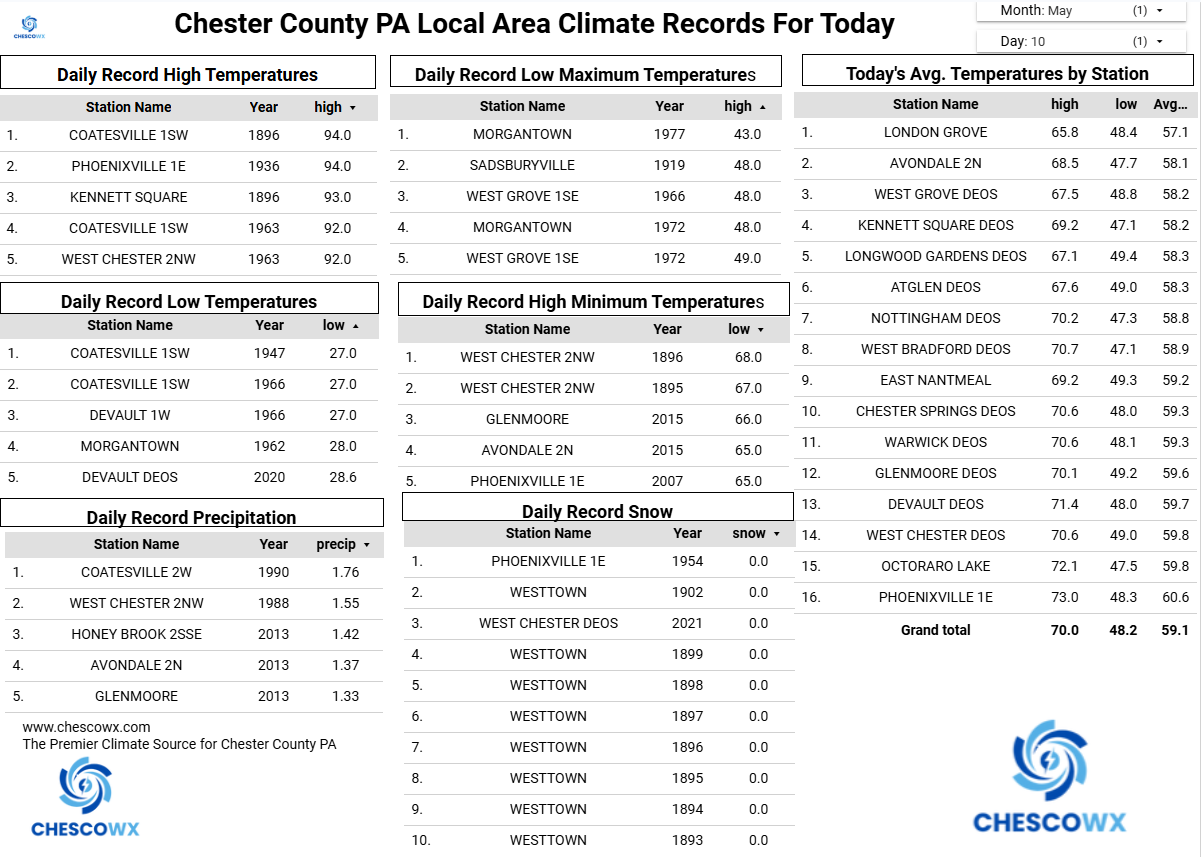
Minimum temperatures this morning were 8 to 14 degrees below normal for today’s date. The lowest was our typical cold spot in Warwick Twp with a low of 35.5. With the exception of Sunday, where temperatures will be close to normal with highs in the low 70’s we should see well below normal temperatures continue for at least the next week. Rain chances increase tomorrow morning into the afternoon. We should see a mostly sunny Mom’s Day on Sunday before more rain arrives Sunday night into Monday. Some models are hinting at almost an inch of rain between Saturday and Monday night.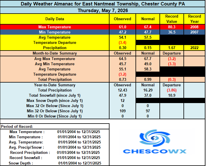
-
E PA/NJ/DE Spring 2026 Obs/Discussion
ChescoWx replied to PhiEaglesfan712's topic in Philadelphia Region
Nice write up! our climate has always and will always move in cycles. Of note with May likely to end with below normal temperatures - this will mark 7 of the last 10 months with below average temperatures here in Chester County. -
Central PA Spring 2026 Discussion/Obs Thread
ChescoWx replied to Voyager's topic in Upstate New York/Pennsylvania
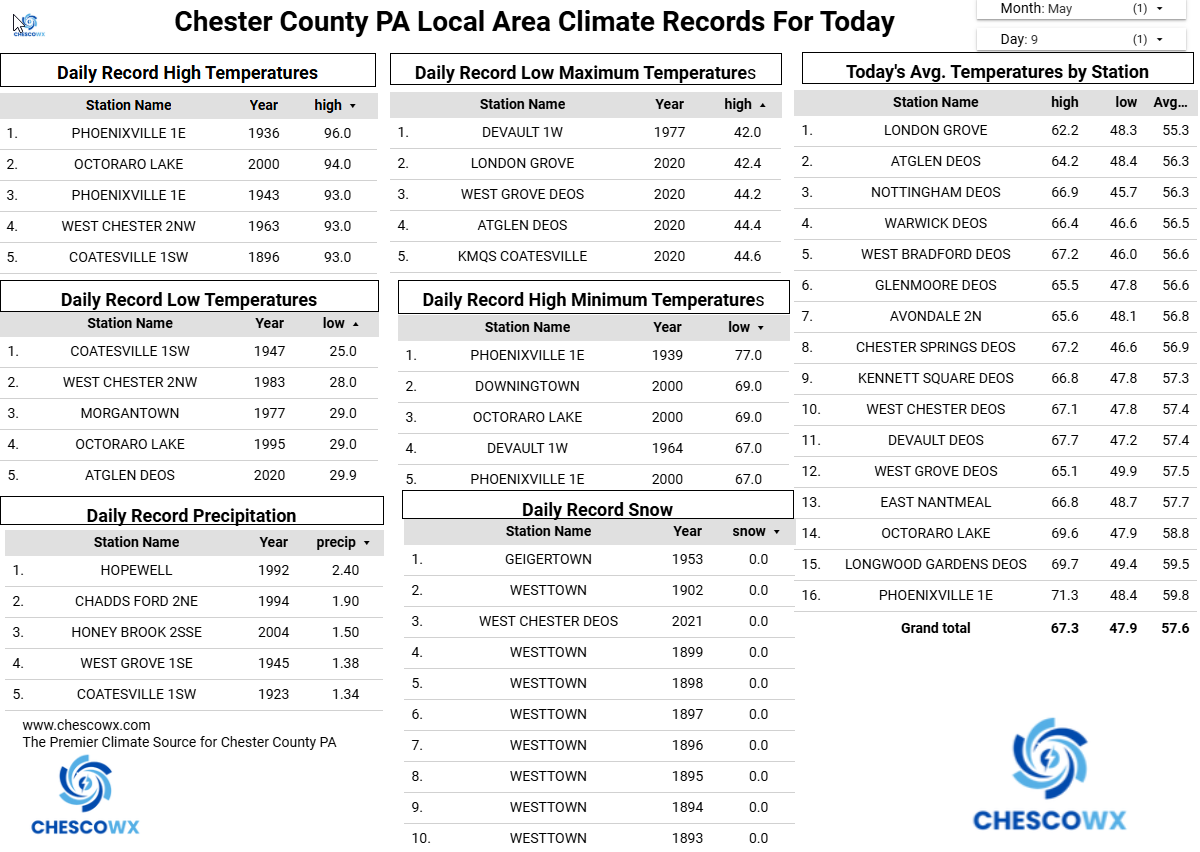
Ten of our last fifteen days have featured below normal temperatures. It looks like much of the next 15 days will also average out with cooler than normal temperatures. After some much needed rain last night we have a great day underway today. Below normal temperatures will continue through Saturday. Rain chances increase again toward Saturday morning before we briefly warm to above normal on Sunday for Mom’s day with highs in the middle 70’s. We turn sharply cooler again to start the new work week.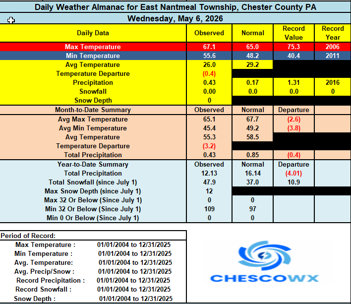
-
E PA/NJ/DE Spring 2026 Obs/Discussion
ChescoWx replied to PhiEaglesfan712's topic in Philadelphia Region
Ten of our last fifteen days have featured below normal temperatures. It looks like much of the next 15 days will also average out with cooler than normal temperatures. After some much needed rain last night we have a great day underway today. Below normal temperatures will continue through Saturday. Rain chances increase again toward Saturday morning before we briefly warm to above normal on Sunday for Mom’s day with highs in the middle 70’s. We turn sharply cooler again to start the new work week.
-
Central PA Spring 2026 Discussion/Obs Thread
ChescoWx replied to Voyager's topic in Upstate New York/Pennsylvania
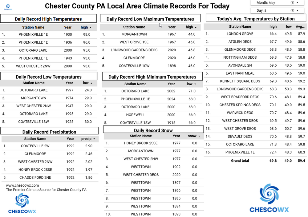
Cooler today with showers we could see up to 0.25" of needed rain. We are at 73% of normal rainfall for the year to date. We remain cooler than normal through Saturday with a brief warmup on Sunday to above normal before temperatures again fall below normal. Overall, the next couple weeks look to average below normal. Our next shower chances will be Saturday.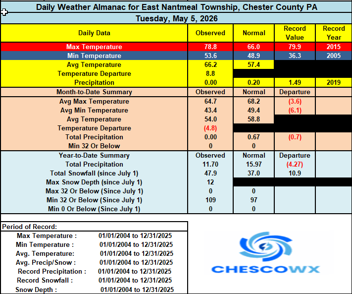
-
E PA/NJ/DE Spring 2026 Obs/Discussion
ChescoWx replied to PhiEaglesfan712's topic in Philadelphia Region
Cooler today with showers we could see up to 0.25" of needed rain. We are at 73% of normal rainfall for the year to date. We remain cooler than normal through Saturday with a brief warmup on Sunday to above normal before temperatures again fall below normal. Overall, the next couple weeks look to average below normal. Our next shower chances will be Saturday.
-
Central PA Spring 2026 Discussion/Obs Thread
ChescoWx replied to Voyager's topic in Upstate New York/Pennsylvania
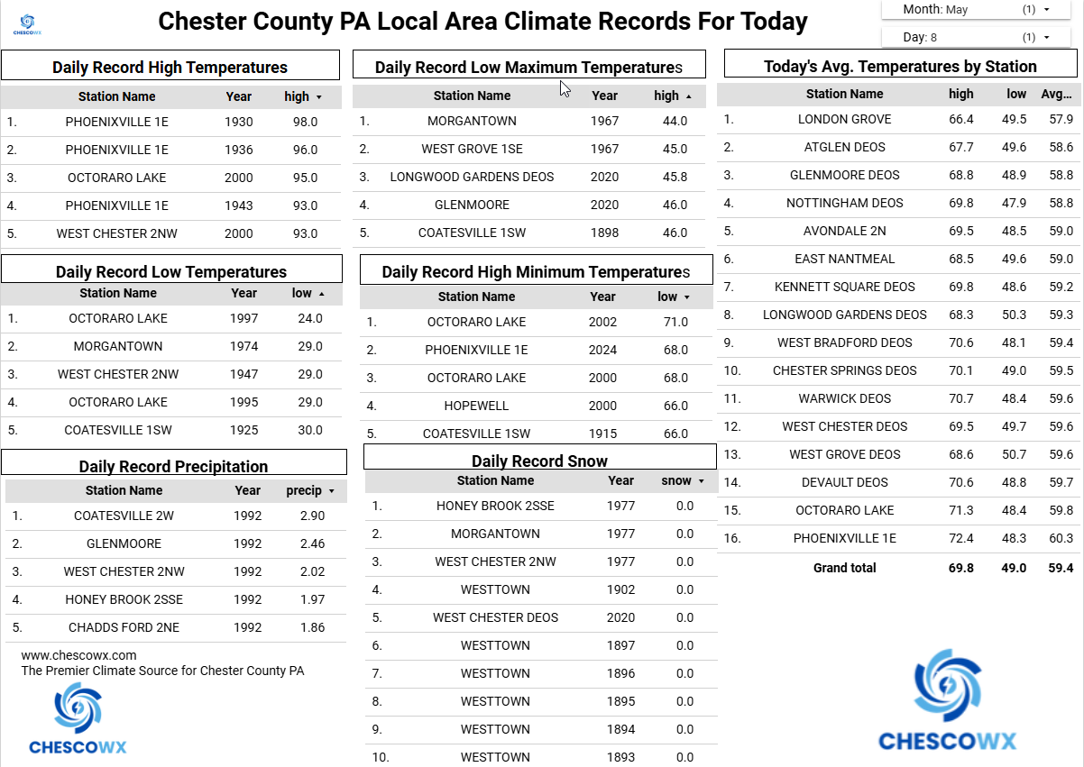
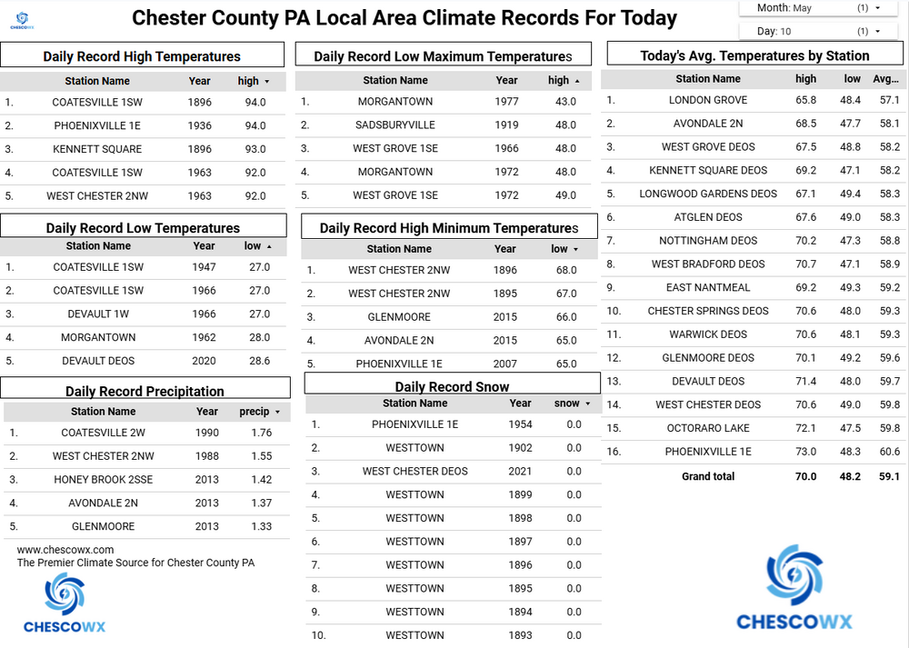
Many lower spots reached the 30's this morning with the Warwick DEOS the chilliest at 30.9 degrees. We warm up nicely today to near normal highs around 70 today. We warm to close to 80 degrees tomorrow before we start another cooling trend. Shower chances also look to increase Wednesday into Thursday before we clear up on Friday. Below normal temperatures look likely from Thursday through the weekend.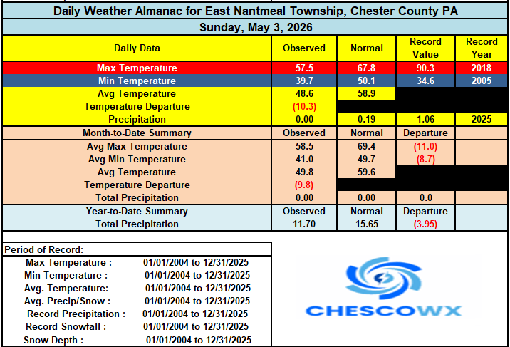
-
E PA/NJ/DE Spring 2026 Obs/Discussion
ChescoWx replied to PhiEaglesfan712's topic in Philadelphia Region
Many lower spots reached the 30's this morning with the Warwick DEOS the chilliest at 30.9 degrees. We warm up nicely today to near normal highs around 70 today. We warm to close to 80 degrees tomorrow before we start another cooling trend. Shower chances also look to increase Wednesday into Thursday before we clear up on Friday. Below normal temperatures look likely from Thursday through the weekend.
-
Central PA Spring 2026 Discussion/Obs Thread
ChescoWx replied to Voyager's topic in Upstate New York/Pennsylvania
Below is from Mount Holly - Is there one from State College? Thanks!