(002).png.f2cbd7c955dc3007a02ab79925b174ec.png)
ChescoWx
-
Posts
11,128 -
Joined
-
Last visited
Content Type
Profiles
Blogs
Forums
American Weather
Media Demo
Store
Gallery
Everything posted by ChescoWx
-
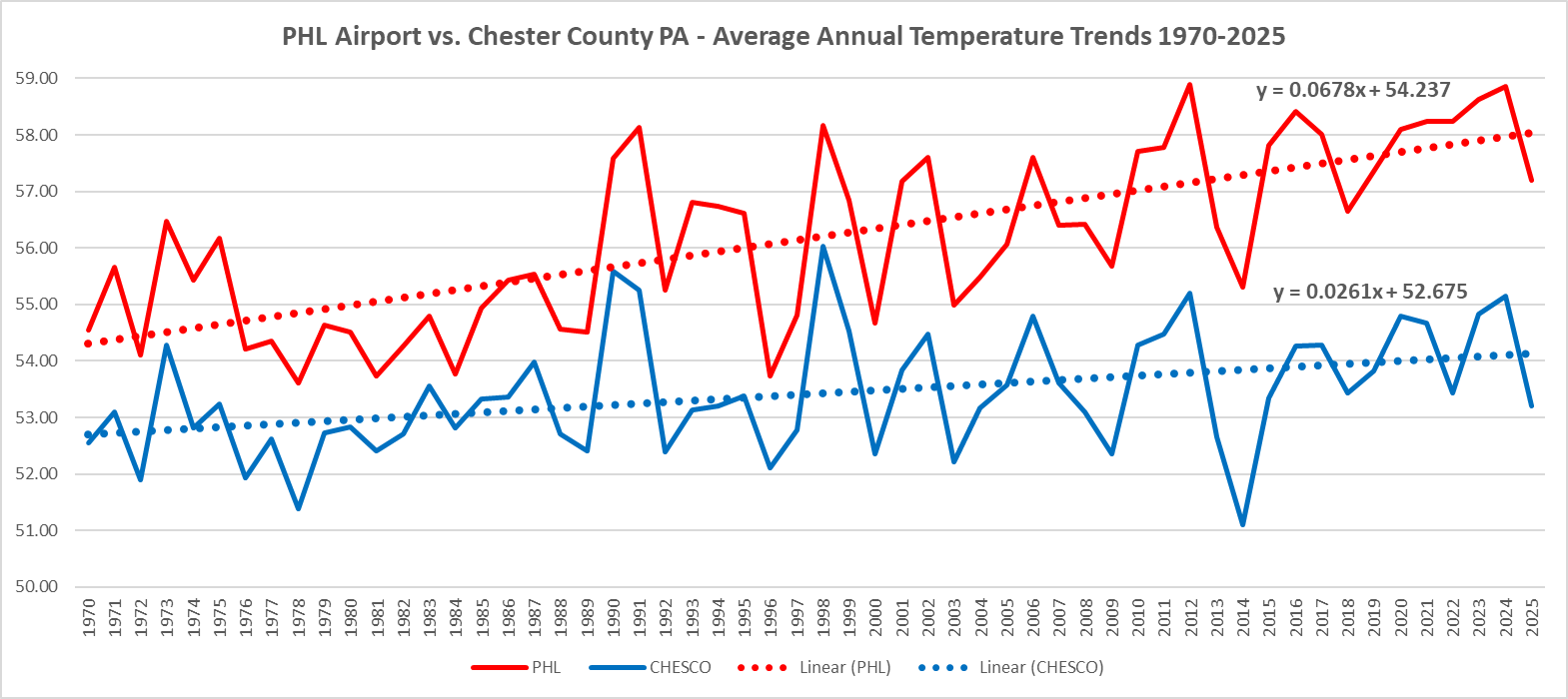
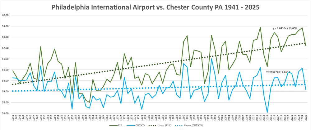
(002).thumb.png.6e3d9d46bca5fe41aab7a74871dd8af8.png) Your amateur altered facts and fake math do not change the facts. To just prove it to you yet again - let's simply take the next period of time after all those changes that you think made such an impact. Let's target the modern era from 1970 through 2025. Again clear as it can be that PHL is clearly and statistically warming faster than Chester County both the trend line and the slope prove this as fact. The gap due to PHL UHI continues to widen - just wait to see by 2036 how much further apart these get!
Your amateur altered facts and fake math do not change the facts. To just prove it to you yet again - let's simply take the next period of time after all those changes that you think made such an impact. Let's target the modern era from 1970 through 2025. Again clear as it can be that PHL is clearly and statistically warming faster than Chester County both the trend line and the slope prove this as fact. The gap due to PHL UHI continues to widen - just wait to see by 2036 how much further apart these get!
-
Fortunately Charlie we have the facts and math to prove clearly how much faster PHL is warming than Chester County PA from 1941 through 2025. Since the growth rate not just to the eye but based on the slope certainly shows that PHL has a much steeper warming growth line than Chester County. Charlie as you can plainly see it is not even close. PHL is warming much faster than Chesco! The facts show this gap has never been wider....well not until we finish this year!
-
Central PA Spring 2026 Discussion/Obs Thread
ChescoWx replied to Voyager's topic in Upstate New York/Pennsylvania
Who is ready for some weather whiplash? After one more unseasonably warm day today we flip to unseasonably chilly starting tomorrow and lasting through at least Sunday. Tomorrow's afternoon temperatures are likely to be more than 30 degrees chillier than today with widespread 50's. We turn even chillier by Saturday with some models hinting at record low maximum temperatures with highs struggling to escape the cold 40's during the afternoon. Some much-needed rain looks to arrive later today and continue off and on through tomorrow. More steady rain arrives Friday night and continues through Saturday. This combination of rain and cold will make Saturday feel more like a raw early March day than Memorial Day Weekend.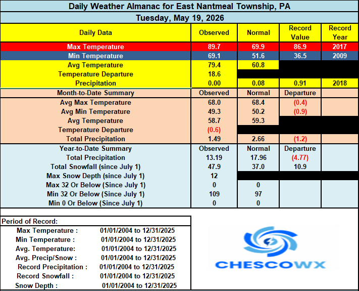

-
E PA/NJ/DE Spring 2026 Obs/Discussion
ChescoWx replied to PhiEaglesfan712's topic in Philadelphia Region
Who is ready for some weather whiplash? After one more unseasonably warm day today we flip to unseasonably chilly starting tomorrow and lasting through at least Sunday. Tomorrow's afternoon temperatures are likely to be more than 30 degrees chillier than today with widespread 50's. We turn even chillier by Saturday with some models hinting at record low maximum temperatures with highs struggling to escape the cold 40's during the afternoon. Some much-needed rain looks to arrive later today and continue off and on through tomorrow. More steady rain arrives Friday night and continues through Saturday. This combination of rain and cold will make Saturday feel more like a raw early March day than Memorial Day Weekend.
-
LOL! One man's mental illness is another man's passion and fun!! I really do love this thread and have a blast with the data and doing point counterpoint with Charlie!! Great stuff! Thanks for participating AdMC!!!
-
PHL still accelerating well above all of Chesco
-
E PA/NJ/DE Spring 2026 Obs/Discussion
ChescoWx replied to PhiEaglesfan712's topic in Philadelphia Region
Almost there up to 89.3 high for the day - nearby Glenmoore DEOS station at 89.8....I think we can do it today!! -
Central PA Spring 2026 Discussion/Obs Thread
ChescoWx replied to Voyager's topic in Upstate New York/Pennsylvania
Here in the NW Philly burbs of Chester County in East Nantmeal (elev. 700 feet ASL) we have hit a high so far today of 88.0 degrees. We have still not hit 90 degrees here this year. I have been at this location for this my 23rd summer. Over those years I have only recorded a 90 degree temperature 76 times or around 3.5 times a typical summer season. To put that in persective the Philadelphia International Airport has in just the last 3 summers recorded a 90 plus reading a whopping 92 times! During the last 22 years PHL is averaging a 90+ reading 32 times a season. -
E PA/NJ/DE Spring 2026 Obs/Discussion
ChescoWx replied to PhiEaglesfan712's topic in Philadelphia Region
Here in the NW Philly burbs of Chester County in East Nantmeal (elev. 700 feet ASL) we have hit a high so far today of 88.0 degrees. We have still not hit 90 degrees here this year. I have been at this location for this my 23rd summer. Over those years I have only recorded a 90 degree temperature 76 times or around 3.5 times a typical summer season. To put that in persective the Philadelphia International Airport has in just the last 3 summers recorded a 90 plus reading a whopping 92 times! During the last 22 years PHL is averaging a 90+ reading 32 times a season. -
Central PA Spring 2026 Discussion/Obs Thread
ChescoWx replied to Voyager's topic in Upstate New York/Pennsylvania
Today will be the hottest day of our brief warm up with today reaching the 90's in all areas - maybe even in the higher spots like here in East Nantmeal. This will however be nowhere close to record levels with the mid to upper 90’s record heat for this date set way back in 1962 remaining safe. Tomorrow will be several degrees cooler and may not reach 90 in all areas. Rain chances will be ramping up with an approaching cold front tomorrow later in the day and will continue through Sunday. Some models are hinting at some of the most beneficial rains we have had in quite some time. We turn chillier than normal for the Memorial Day weekend with highs likely to remain in the 50's to near 60 degrees both Friday and Saturday. The area farmers and green thumbs have their fingers crossed even if it could impact some holiday plans.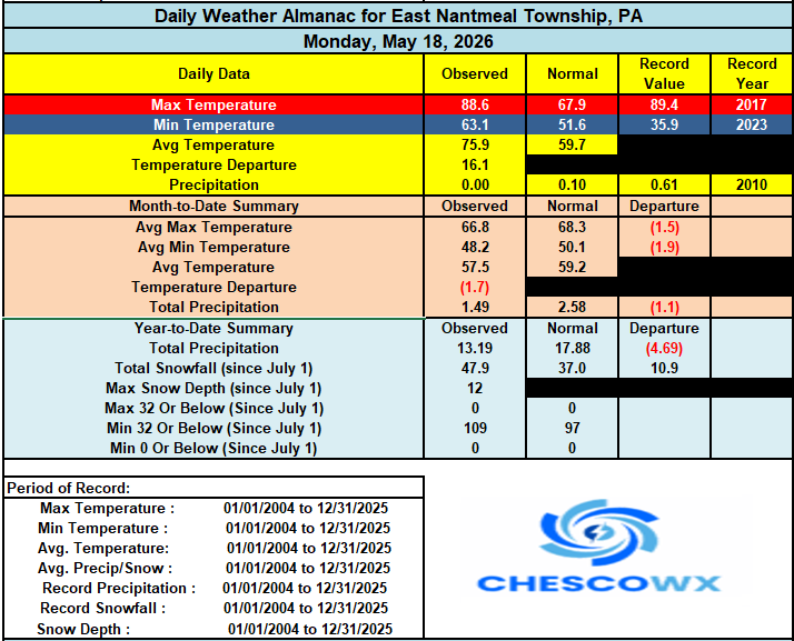
-
E PA/NJ/DE Spring 2026 Obs/Discussion
ChescoWx replied to PhiEaglesfan712's topic in Philadelphia Region
Today will be the hottest day of our brief warm up with today reaching the 90's in all areas - maybe even in the higher spots like here in East Nantmeal. This will however be nowhere close to record levels with the mid to upper 90’s record heat for this date set way back in 1962 remaining safe. Tomorrow will be several degrees cooler and may not reach 90 in all areas. Rain chances will be ramping up with an approaching cold front tomorrow later in the day and will continue through Sunday. Some models are hinting at some of the most beneficial rains we have had in quite some time. We turn chillier than normal for the Memorial Day weekend with highs likely to remain in the 50's to near 60 degrees both Friday and Saturday. The area farmers and green thumbs have their fingers crossed even if it could impact some holiday plans.
-
Charlie you are again misinterpreting the data. The increasing hot years in Philly during recent years is of course the UHI contamination at PHL.
-
Central PA Spring 2026 Discussion/Obs Thread
ChescoWx replied to Voyager's topic in Upstate New York/Pennsylvania
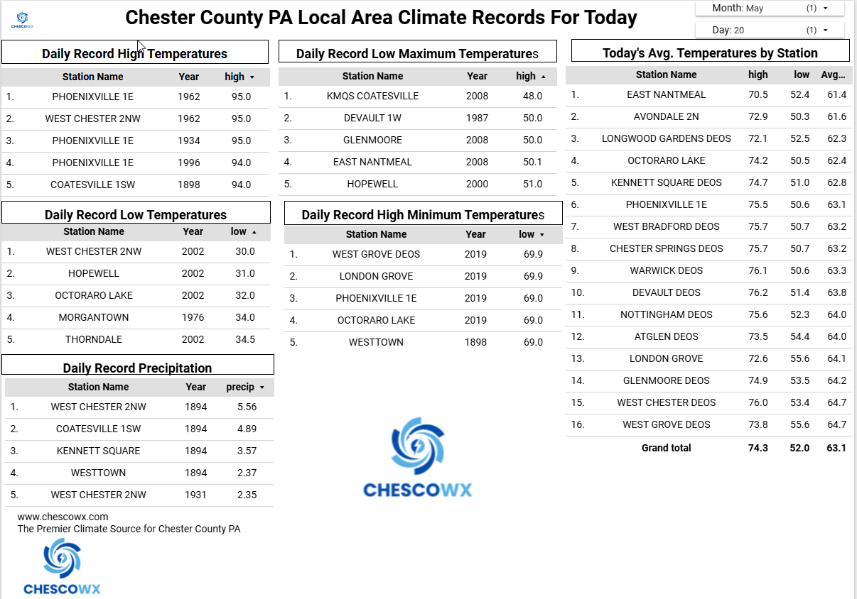
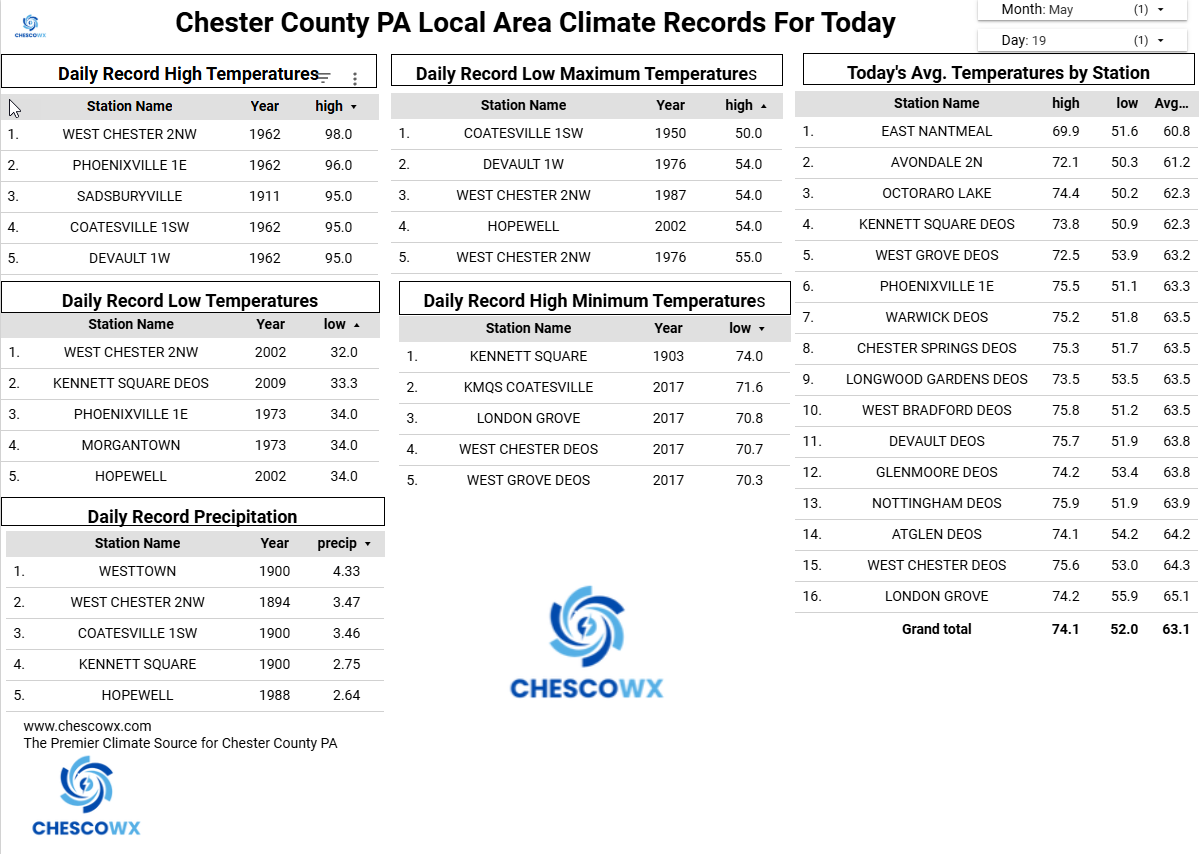
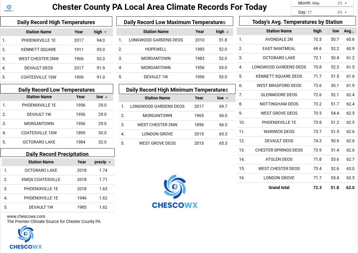
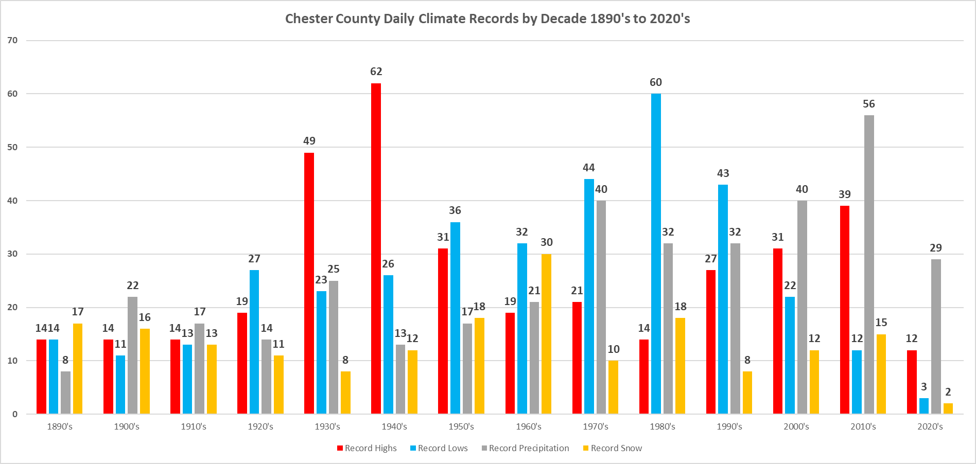
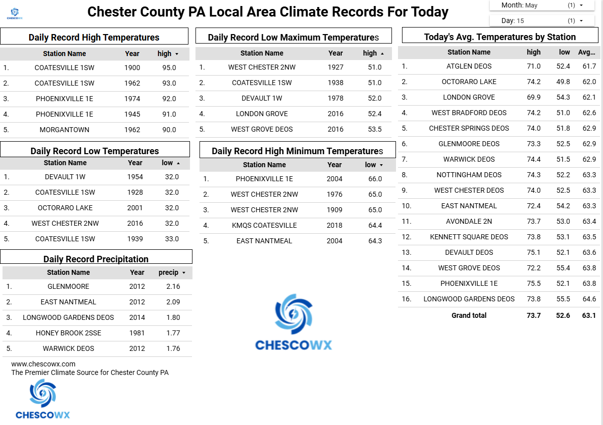
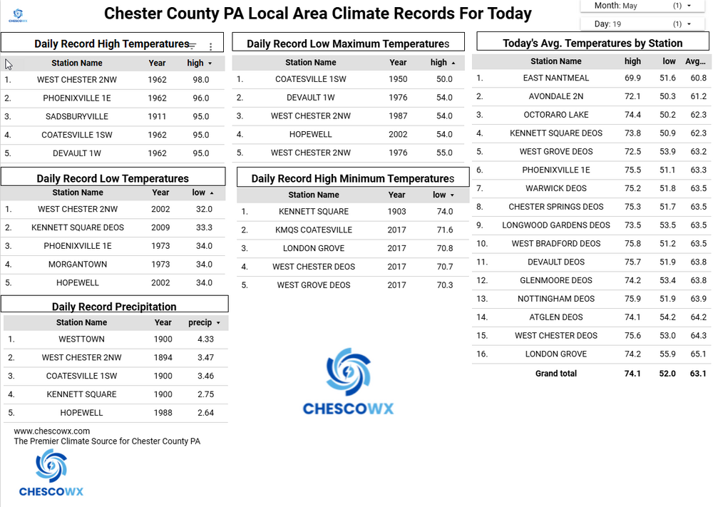
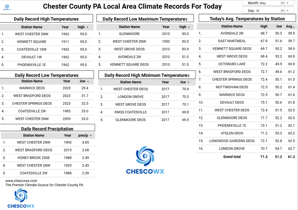
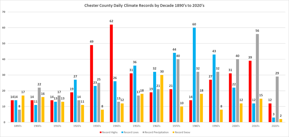
Below is an analysis of when our daily climate records have occurred here in Chester County PA. Temperature, Precipitation and Snow daily records. Of note the decades of the 1930's through the 1950's accounted for 39% of our record high temperature records. The most daily record highs were recorded during the 1940's. The decades of the 1970's through 1990's recorded 40% of all of our daily record low temperatures across the county. With the 1980's recording the most daily record low temperatures. Precipitation wise the 2010's saw the most daily record precipitation records while the 1960's saw the greatest number of daily snow records.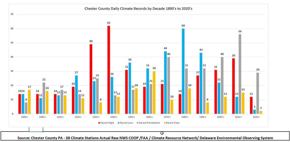
-
E PA/NJ/DE Spring 2026 Obs/Discussion
ChescoWx replied to PhiEaglesfan712's topic in Philadelphia Region
Below is an analysis of when our daily climate records have occurred here in Chester County PA. Temperature, Precipitation and Snow daily records. Of note the decades of the 1930's through the 1950's accounted for 39% of our record high temperature records. The most daily record highs were recorded during the 1940's. The decades of the 1970's through 1990's recorded 40% of all of our daily record low temperatures across the county. With the 1980's recording the most daily record low temperatures. Precipitation wise the 2010's saw the most daily record precipitation records while the 1960's saw the greatest number of daily snow records.
-
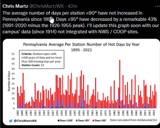
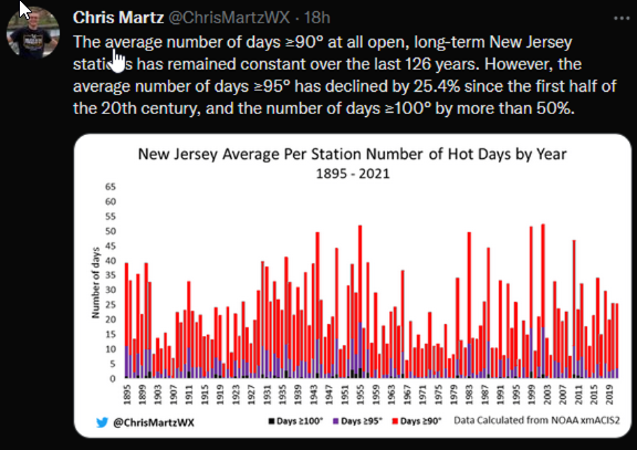
No cherry picking here as fortunately we have climate facts to fall back on - a quick look for example at when many of the records were set in 1936 the 9th and 10th were both 111 degrees at Phoenixville - even eliminating them still has Coatesville and West Chester at 105 and 104 degrees for records still occurring in the 1930's. Surrounding stations were also very hot. Of note the number of hot days across all of PA And NJ is in fact decreasing since the first half of the 20th century not increasing at all!!
-
Central PA Spring 2026 Discussion/Obs Thread
ChescoWx replied to Voyager's topic in Upstate New York/Pennsylvania
A hot start to the week with our warmest day tomorrow before a sharp chill down by Memorial Day weekend. Many valley locations could touch 90 degrees both today and for sure tomorrow. Some higher ridges may fall a bit short of 90 both days. By Thursday temperatures should be at least 20 degrees cooler than Wednesday. In fact, while the current NWS forecast has highs in the mid 60's both Friday and Saturday I suspect much of Chester County will struggle to get out of the chilly 50's both Friday and Saturday. Shower chances increase on Wednesday with shower chances continuing through the weekend.
-
E PA/NJ/DE Spring 2026 Obs/Discussion
ChescoWx replied to PhiEaglesfan712's topic in Philadelphia Region
A hot start to the week with our warmest day tomorrow before a sharp chill down by Memorial Day weekend. Many valley locations could touch 90 degrees both today and for sure tomorrow. Some higher ridges may fall a bit short of 90 both days. By Thursday temperatures should be at least 20 degrees cooler than Wednesday. In fact, while the current NWS forecast has highs in the mid 60's both Friday and Saturday I suspect much of Chester County will struggle to get out of the chilly 50's both Friday and Saturday. Shower chances increase on Wednesday with shower chances continuing through the weekend.
-
Central PA Spring 2026 Discussion/Obs Thread
ChescoWx replied to Voyager's topic in Upstate New York/Pennsylvania
We will see a brief stretch of above normal temperature days through mid-week before we turn back to below normal temperatures by Thursday and through the Memorial Day Weekend. Many lower valley locations should reach 90 degrees both tomorrow and Tuesday. Higher spots across Chester County will always struggle to touch 90. Rain chances increase by Wednesday PM with the cold front, and it does look a bit unsettled as we move into the holiday weekend.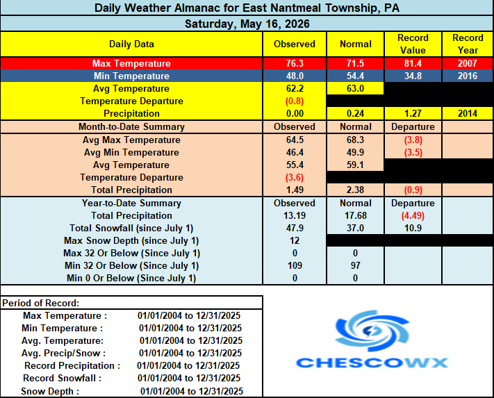

-
E PA/NJ/DE Spring 2026 Obs/Discussion
ChescoWx replied to PhiEaglesfan712's topic in Philadelphia Region
We will see a brief stretch of above normal temperature days through mid-week before we turn back to below normal temperatures by Thursday and through the Memorial Day Weekend. Many lower valley locations should reach 90 degrees both tomorrow and Tuesday. Higher spots across Chester County will always struggle to touch 90. Rain chances increase by Wednesday PM with the cold front, and it does look a bit unsettled as we move into the holiday weekend.
-
E PA/NJ/DE Spring 2026 Obs/Discussion
ChescoWx replied to PhiEaglesfan712's topic in Philadelphia Region
So tough for the higher spots out here in Chesco to touch 90....but it will be close. Valley spots will certainly get above 90 -
Not misleading at all simply presenting the actual climate data for the county. You are just as always attempting to explain away the facts but those facts cannot be changed! The above list of when records occurred is actual and real climate data you cannot somehow recast or redo the above data because it fails to fit a narrative.
-
Below is an analysis of when our daily climate records have occurred in the philly burbs of Chester County PA. Temperature, Precipitation and Snow daily records. Of note the decades of the 1930's through the 1950's accounted for 39% of our record high temperature records. The most daily record highs were recorded during the 1940's. The decades of the 1970's through 1990's recorded 40% of all of our daily record low temperatures across the county. With the 1980's recording the most daily record low temperatures. Precipitation wise the 2010's saw the most daily record precipitation records while the 1960's saw the greatest number of daily snow records.
-
Central PA Spring 2026 Discussion/Obs Thread
ChescoWx replied to Voyager's topic in Upstate New York/Pennsylvania
We start our warmup today peaking with temperatures not far from 90 by Wednesday. A cold front crosses the area later Wednesday with rain chances increasing and we trend back to near normal temperatures by Thursday and below normal temperatures for the start of Memorial Day Weekend.

-
E PA/NJ/DE Spring 2026 Obs/Discussion
ChescoWx replied to PhiEaglesfan712's topic in Philadelphia Region
We start our warmup today peaking with temperatures not far from 90 by Wednesday. A cold front crosses the area later Wednesday with rain chances increasing and we trend back to near normal temperatures by Thursday and below normal temperatures for the start of Memorial Day Weekend.
-
Central PA Spring 2026 Discussion/Obs Thread
ChescoWx replied to Voyager's topic in Upstate New York/Pennsylvania
16 of our last 20 days have featured below average temperatures. Today will be another below average day before we start a strong warmup with temperatures by Tuesday approaching 90 degrees across especially the valley locations across the County. A cold front will cross the area later Wednesday with a chance of some showers. Following that front we should see temperatures fall back closer to normal levels by the end of next week.