

RitualOfTheTrout
-
Posts
3,672 -
Joined
-
Last visited
Content Type
Profiles
Blogs
Forums
American Weather
Media Demo
Store
Gallery
Everything posted by RitualOfTheTrout
-
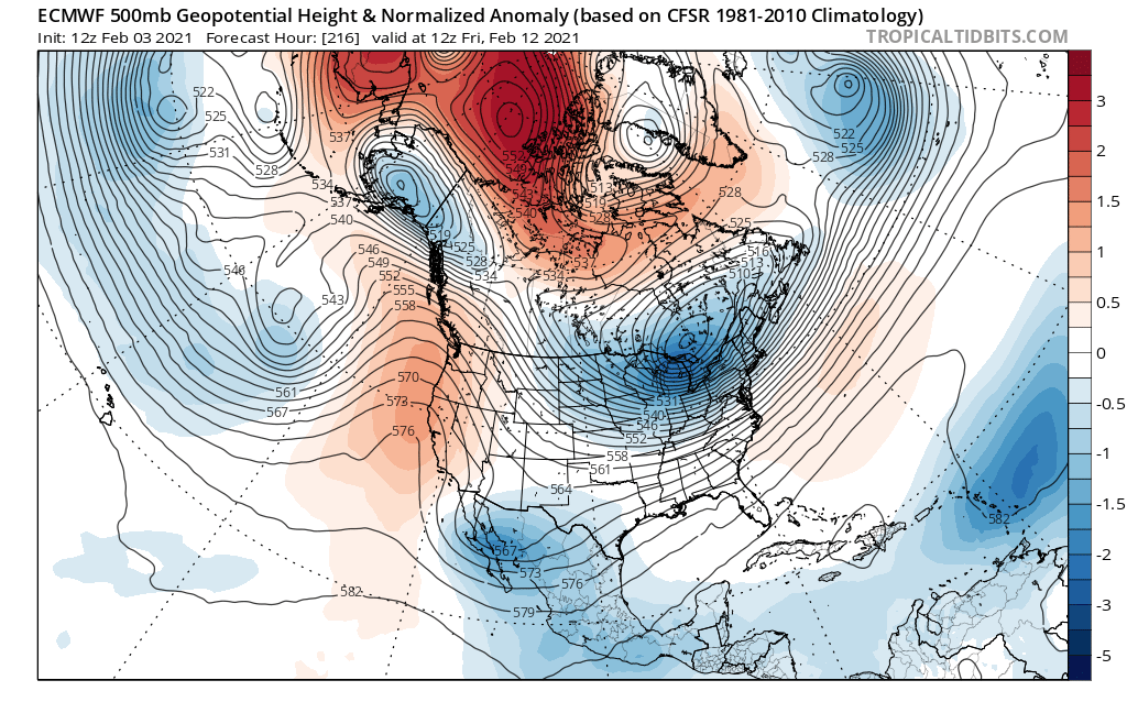
 Models are pulling back on the Arctic blast, maybe a delayed but not denied type deal, but what was once looking pretty brutal has moderated due to the trend to pop a ridge in the East in response to splitting the PV rather than one elongated piece of the PV with majority of the energy in the East. Now look at today, PV is split with the stronger piece out west, pumping a ridge that connects all the way up the NAO block. Throw a storm into that 500 map and you can see anything that develops would likely go to the west of us and pump heights even more with SW flow ahead of it. Recipe for a warm up for sure. Going a few days out from here the piece of PV out west rotates eastward and I would think some cold will follow. That of course assuming that progression is correct.
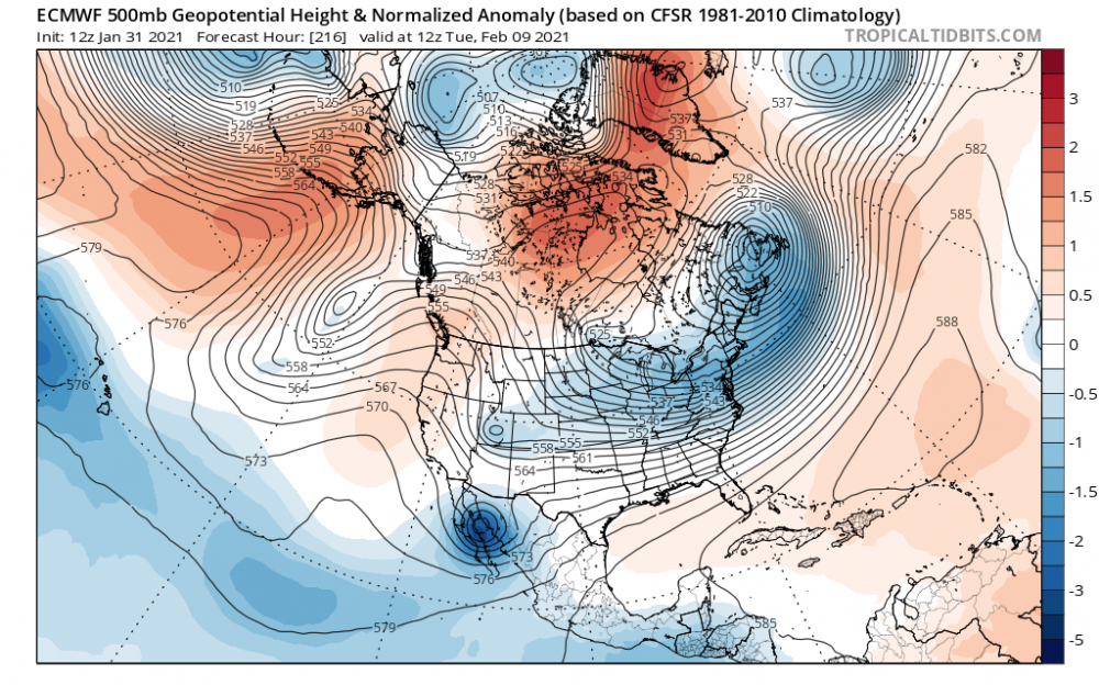

-
Yeah I'm not saying any one outcome is more likely but I think we have all seen the models lose a storm in the mid range only to bring it back a few days later. Even if it fails looks like several chances to roll the dice coming up.
-
No guarantees a decent pattern delivers and if it does that any one area will get a big storm. I still think the window for a Sunday timeframe storm is still open, models still have A storm, just most slide it South. Wouldn't shock me to see it pop back up in the next couple days.
-
Wind really starting to gust out there, snow blowing around like crazy.
-
Getting a pretty moderate burst of snow right now, on par if not surpassing anything I saw yesterday.
-
That band is interesting for sure, looks like it has a dual lake connection, originating off ontario the going over erie. I wonder how often central ohio gets LES from lake ontario lol These systems that stall out do some weird things, normally I'd think a storm isn't able to generate a flow like that because it's moving to fast to establish a persistent wind trajectory like that.
-
NWS talking about the potential already in discussion: Also of note for late in the weekend is a pattern supportive of yet another potential nor`easter as the arctic air advances into the region. There remains variability among the models as to whether a lead wave can phase with the digging nrn-Plains trough to yield a favorable set-up for PA snow or whether the cold low-level air will outpace the upper trough. Stay tuned... It would be great to get another storm followed by a big Arctic blast. Opportunity for snow on snow for sure if that verified.
-
NAM showing we get some action from the coastal tomorrow. Probably steady light to occasionally moderate snow all day. Thus far the primary hasn't really delivered for my yard, seems the better rates are staying just to the west right now. Will have to see what happens as the progresses.
-
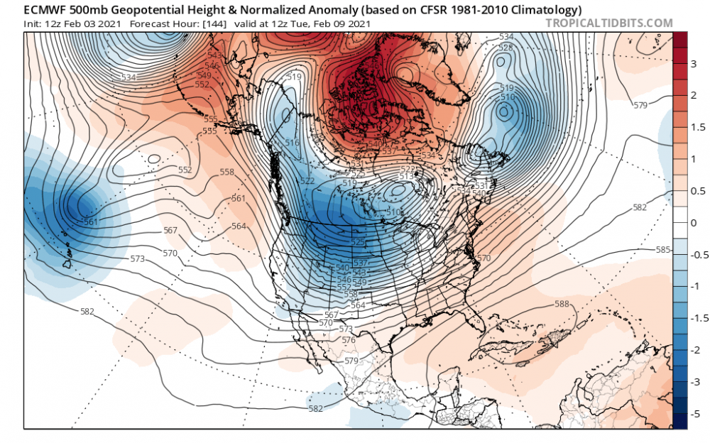
Feb shaping up to not be a dumpster fire like most of the seasonal forecast said. Probably in part to the SSW and persistent blocking. Maybe also some feedback from weakening La Niña? Saw that Euro run, to Far East meh.. Next! Lol j/k I love when we have multiple current/ short range / long range threats all going at once.
-
Snow starting to resume now, some of the half inch I had from this morning melted, temp hovering around 32, I’d expect it will cool if we get some heavier bursts.
-
That’s my feeling too; should have snow in the air during daylight hours for the next 2 days. Having that blockbuster December has made it easy to just sit back and enjoy whatever else we get without fretting if we miss a storm it might be the last chance of the season. At the end of this maybe you can’t go stick a ruler in your yard and measure 6 because it came over a longer period but so long as we stay below freezing at the surface the frozen ground and still low sun angle should aid our efforts. If we miss it would be more likely due to lack of qpf from a quicker transfer or further south track. The NAM did show a bit of a lull / light precip late morning / early afternoon before it picked back up this evening.
-
A dusting here so far with light snow coming down. We are really into nowcast time, but all the models still look good and NWS still thinks a band will develope with 1-2 inch per hour rates. Still need to give it time to play out before start sweating a bust. We've been good this year meeting or exceeding expectations, hopefully we can continue that theme for this storm.
-
I think the confusion is stemming from the advisory period vs total storm duration. They have 3-4 inches over a 24 hour period starting at (10pm Saturday - 10pm Sunday) but storm totals ending Tuesday of 6-8 inches.
-
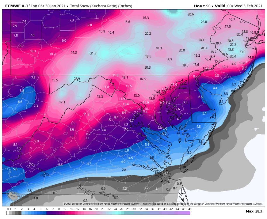
Central PA - Jan 31 to Feb 2 Winter Storm
RitualOfTheTrout replied to MAG5035's topic in Upstate New York/Pennsylvania
Just popping in so I can join y'all for a free beer. Really just wanted to say good luck, we've had a solid winter so far in the western part of the state, glad to see a storm that looks to have a little something ( in some cases a lot of something) for everyone. -
Agree, nice illustration / explanation. You can literally overlay that in your head with the snow map it spits out and see how the big totals correlate. Ocean water is above average if I remember correctly, that should really help fuel some crazy rates out east and maybe help us s little too if the stars align. I think we all agree let's max out with the primary, then anything from the ccb is dessert.
-
6z Euro not a bad look, you can really see influences from the coastal pretty far west but not quite enough for here. Either way there seems to be a consensus forming for a narrow swath of decent totals (5-10 inches) somewhere in SWPA.
-
18z NAM and 18z Euro look pretty close, 18z Euro actually better than 12z for Allegheny County. Will be interesting if this look holds, NWS might be upping totals.
-
All good points. I think we should also consider our climotolgy, the warm tongue is real and is usually stronger than modeled so maybe the GFS isn't that off its rocker. Those maps with the big totals were fun to look at and illustrated what "could" happen if like 20 variables all flipped in our favor.
-
We are like 48 hours out now so really things should start to come to a consensus 12z / 00z today you'd think right?
-
Ukmet looks decent, pretty similar to NAM.
.thumb.png.db887574d30214609e26c53a7370953e.png)
-
we can hope right?
-
ICON is drunk lol, 1.25in qpf in northern Allegheny. I don't follow it closely but I'd be willing to bet that is overdone.
-
That screw zone will likely move around still, I think if in general our area does well you should be ok, plus maybe a shot at some upslope after the storm.
-
NAM stops the bleed South, actually ticked back North this run. Still a solid Precip shield over us at hour 84.


.png.dd476cbf50aebf1ece4a351183ac72ef.png)