

RitualOfTheTrout
-
Posts
3,697 -
Joined
-
Last visited
Content Type
Profiles
Blogs
Forums
American Weather
Media Demo
Store
Gallery
Everything posted by RitualOfTheTrout
-
 That's the best the Euro has looked for several runs now. Seems there is little NW shift with all the 6z models.
 -
The general trend today has been to shift the totals east. Given the setup I had in my head 6 inches was probably the upper limit on this for us. If I had to put out a guess based on today's runs I'd say 2-4.
-
I counted 25 members on the 6z EPS using Allegheny county as the measuring stick that give us a solid 6-8 in storm. That's an improvement over yesterday. My only concern is the last few storms the Euro seemed to be the most amped up so take that caveat how you want at this point. Other models have also increased totals slightly for us too. Overall things trended in the right direction overnight.
-
Heh, man what a track.. Nothing like these old forecasts with big CRT monitors etc in the background.
-
Yeah, Nobody should be discounting any outcome, case in point just quickly looking at 18z GEFS there are more members getting the whole state in on the action.
-
Stronger storm \ negative tilt trough sooner and or slightly less confluence to the north and I think it could easily shift enough to get us more involved. Of course things could trend the other way and we are partly cloudy cold and dry. Either way, we all know what was modeled today is very unlikely to be the exact end result hence why people always say they don't want to be in the bullseye 5-6 days out.
-
I’ll echo that sentiment. Looks like the upcoming blocking regime may help mute the Nina effects. It really just started showing up, a few days ago it looked like lights out for awhile. In my experience that’s usually how it goes when the blocking actually happens; models catch on in the medium range rather than chasing day 14 “trends”. If we can get the pacific just little more favorable (more ridge out west) that would aid our chances. Either way it looks active next week, I’d be surprised if there isn’t at least one good snow storm somewhere in the East. Time will tell how many rolls of the dice we get. If blocking is a recurring theme that should help make this a decent year despite the Nina. Now watch the incoming geomagnetic storm fudge up the stratosphere and wreck the blocking.
-
Western Allegheny is getting smoked by looks on radar. Looks like some 35dbz returns on radar. I've been teetering on the Eastern edge of the better rates but heck of an event to start December for sure. Some areas may hit December whole month climotolgy snow totals on day one.
-
Coming down pretty good now. With sunset approaching pavement starting to get covered in a few places.
-
.NEAR TERM /THROUGH TONIGHT/... Snow will generally continue overnight as moisture wraps around an upper low tracking into southeastern Canada. An embedded shortwave will give one last southward push of snow this evening, potentially aiding in heavy snow band development along the I-80 corridor. During this last push, strong upper jet dynamics, steepening low level lapse rates and enough dendritic growth will promote an additional 1-2" of snow across eastern OH and southwestern PA while northwestern PA and the eastern ridge tops could see another 3-6" of snow. Thus, the Winter Storm Warnings and Winter Weather Advisories will continue. I think if the above comes to fruition definitely not out of the question some areas in SWPA push 6 especially areas already closing in on 4in.
-
I've been watching that area on radar, it's been just to the NW of mby now for awhile, hopefully it can push SE just a bit more as there are some steady 20-25 dbz returns showing up.
-
Hard to get a good measurement with some melting with the warm ground but I'd say somewhere between 1.5in 2in at 11am. I woke up around 4am and we had flipped to snow, but there was nothing accumulated at the time.
-
I think the main difference here is the storm stalls out for a bit once we get on the cold side. That combined with some lake enhancement should prolong the window vs a storm taking the same track that just zips off to the NE. Not saying to expect high end of any of the totals but I have more confidence than usual given the setup.
-
Can’t complain about a 1-3 to start Meteorological Winter. This will be interesting to see how fast temperatures can crash. Afterwards, pattern looks active. Given it’s still early and LaNina favored climo, cold air might be problematic but at least for now doesn’t appear we will be in a shutout pattern to start the season.
-
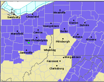
Picture is worth a thousands words... Insanity Winter 2018-2019 Is Doing the Same Thing Over and Over Again and Expecting Different Results.
-
Just miserable cold rain.. Maybe we should start tracking mud slides.
-
Easy there... Let's not get carried away lol. I need a new lawn mower this spring so I'm even less enthusiastic about grass cutting season starting. Anyone have any good recommendations on a good push mower? Prefer non-self propelled. I had a basic Craftsman with a 5.50hp Briggs and Stratton engine but it would tend to bog down at time. It was a good mower though otherwise, started on first pull even after long time in the garage. Had it 11 years but it started smelling like gas while sitting in the garage this past year but no evidence of a leak and revving up and down while running. Then this fall on the last cut it started backfiring then wouldn't start. Not sure how interested I am in trying to fix it.
-
That and most stores will be empty from a people perspective. I think everyone blitzed the grocery stores last night and early morning.
-
Lol I will say I expected more from this winter to this point. Still has time to redeemed itself and a favorable outcome this weekend would be a good start.
-
Euro on board with similar output:
-
This. I agree by the way the rule is written there was a valid reason to "review" the play but it was ruled a touchdown on the field. He was down on his knee with full control of the ball before making a move towards the goal line, had control of the ball has it broke the plane of the goal line up and until there was some movement as his hands hit the ground. It's really leaving this interpretation up to a human and I certainly didn't think the outcome from video review was 100% conclusive.. In other news the snow storm we had a few days back on Christmas day has been awarded to NE, ruin our football and steal our snow!
-
This winter is so depressing I can't even go into the New England forum and live vicariously through them...
-
I'd love to live there when you can count on LES almost every year...
-
You referring to the blizzard last year? I got like 4-5 inches out of that, just missed the good stuff. So I'll reserve the right to cry and moan about frozen water (or lack there of) falling from the sky and laying in my yard.
-
So since this seems to be over performing for everyone (posters in the South especially) what is better, having a big snowfall modeled at least 2-3 days in advance and it actually verifying so you get to soak in all the hype etc, or something like this that ends up being more than forecast with advisories and warnings be added \ upgraded on the fly?



