

RitualOfTheTrout
-
Posts
3,697 -
Joined
-
Last visited
Content Type
Profiles
Blogs
Forums
American Weather
Media Demo
Store
Gallery
Everything posted by RitualOfTheTrout
-
 Yeah, pretty wide swath of clearing over SW PA right now. It will be interesting to see if this has any effect on thunderstorm development later in the evening.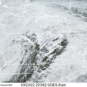
-
Western PA/Pittsburgh Winter 2021/22 Discussion
RitualOfTheTrout replied to meatwad's topic in Upstate New York/Pennsylvania
Pretty much me this weekend: Special Weather Statement National Weather Service Pittsburgh PA 1020 PM EST Sat Mar 12 2022 PAZ013-014-020>022-073-130415- Armstrong-Butler-Lawrence-Westmoreland-Beaver-Allegheny- 1020 PM EST Sat Mar 12 2022 ...A HEAVY SNOW BAND WILL AFFECT NORTHEASTERN BEAVER...SOUTHERN LAWRENCE...SOUTHERN BUTLER...NORTHEASTERN ALLEGHENY...NORTHWESTERN WESTMORELAND AND SOUTHWESTERN ARMSTRONG COUNTIES... At 1015 PM EST, a snow band was located north of Pittsburgh and mostly stationary; 1-2 inches snowfall could occur within this band. Winds in excess of 30 mph are possible with this snow band. Locations impacted include... Cranberry, New Castle, Vandergrift, Apollo, New Kensington, Lower Burrell, Harrison Township, Ellwood City, Arnold, Tarentum, Natrona Heights, and Meridian. This includes the following highways... Pennsylvania Turnpike between mile markers 1 and 19. Interstate 79 in Pennsylvania between mile markers 81 and 96. Interstate 376 in Pennsylvania near mile marker 14. LAT...LON 4076 7971 4053 7952 4057 7982 4090 8052 4105 8052 TIME...MOT...LOC 0317Z 299DEG 45KT 4090 8036 Lol, we got snow here and it was fun sitting in the hot tub during a snow squall but totally feeling jealous missing the best snow of the season back home.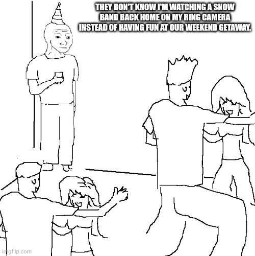
-
Western PA/Pittsburgh Winter 2021/22 Discussion
RitualOfTheTrout replied to meatwad's topic in Upstate New York/Pennsylvania
No doubt it will start melting Sunday but should look pretty wintry Saturday. It is March, snow pack retention is unrealistic. That's why I say go big or go home in March, bring it hot and heavy over a short period of time and enjoy the rates because you know it probably starts melting shortly after. -
Western PA/Pittsburgh Winter 2021/22 Discussion
RitualOfTheTrout replied to meatwad's topic in Upstate New York/Pennsylvania
I'll be in deep creek for this, looks to be in the bullseye so to speak. Forecast there is 4-8 with 45-55mph winds then possibly localized blizzard conditions in NW flow after the synoptic portion. I didn't plan the trip with the intention to chase but looks like its going to work out. This may ruin my expectation for winter weather in my own yard lol Given the dynamics of this storm and time of year I'd think it has a better chance of over performing even though the track is a bit further SE and more progressive than it looked a few days ago. Keep your expectation in check and enjoy what happens, I think there will still be a period of heavy snow and post frontal passage the wind gusts should be impressive with embedded snow. Most likely our last snow even to track until next season. -
Western PA/Pittsburgh Winter 2021/22 Discussion
RitualOfTheTrout replied to meatwad's topic in Upstate New York/Pennsylvania
I fully expect a bullseye for our area on this one. Taking a weekend trip to deep creek so I'll probably miss NW again but only this time NW will be my yard back at home lol. Its a pretty fast moving system, but I'd expect a period of pretty heavy snow out of it and our area is in the game to get in on that at least as of how things look right now. Meanwhile the scene outside is still. -
Western PA/Pittsburgh Winter 2021/22 Discussion
RitualOfTheTrout replied to meatwad's topic in Upstate New York/Pennsylvania
Yeah total paste job out there right now. Early morning in March Sun angle not a big influence either especially with heavy rates. I put the snow shovel / sleds away. Kids boots / gloves literally Monday. Ma Nature calling my bluff. -
Western PA/Pittsburgh Winter 2021/22 Discussion
RitualOfTheTrout replied to meatwad's topic in Upstate New York/Pennsylvania
When I left for work this morning it was raining... Forecast called for mainly rain. It was like 32-33 at the surface and I figured great another cold rain event. Paid no attention to the outside until I overheard people at work talking about all the snow and I wasn't expecting this today talk so I run over to the window like a little kid to see the snow coming down. lol This is why you can't ever sleep on March for a surprise snowfall or two. -
Western PA/Pittsburgh Winter 2021/22 Discussion
RitualOfTheTrout replied to meatwad's topic in Upstate New York/Pennsylvania
If by over you mean an end to any chance if sustained cold / snow cover / all snow events then I'd agree, but also state by this time of year that's probably true a majority of srasons. Definitely still reasonable to expect some overnight coatings or a well timed storm though for the next 6 weeks so not over by that metric. -
I think he posted it just as an example of how much our corner if the state sucks for winter weather sometimes. There's been more times than I'd like to recall where we had similar maps but the advisories and warning were for snow.
-
Western PA/Pittsburgh Winter 2021/22 Discussion
RitualOfTheTrout replied to meatwad's topic in Upstate New York/Pennsylvania
No doubt wasting cold is a disappointment. Getting 5 inches of rain but hitting average or below average temperatures for any winter month could easily be considered frustrating. They are just saying that scenario does not constitute a torch in terms of temperatures. The winter overall to hit average snowfall is needing a more and more extreme storm to make up the difference but nothing we can do about it. Not saying this to you directly but just in general we all need to just enjoy what snow we do get. We all know our climo here and keeping expectations in check goes a long way towards finding the silver linings. We did have that solid stretch in January with sustained snow cover and several snow globe type days. This hobby really is a what have you done for me lately thing, but you need to roll with the punches, not compare your yard to somewhere that averages double and just make an effort to take a step back and enjoy when things are going well and get outside with the kids / dogs / yourself and take it all in because we all know it won't last. Bickering and arguing over it only makes the atmosphere in the thread childish and miserable. -
Any chance that work place training is "How to remain respectful and professional with colleagues after the 12z model runs take away your snow."?
-
Western PA/Pittsburgh Winter 2021/22 Discussion
RitualOfTheTrout replied to meatwad's topic in Upstate New York/Pennsylvania
Yeah I agree, a torch is a long string of consecutive above average days and in general for a month to be considered a torch I'd expect the average monthly temperature to be significantly above average. The storm on the 2nd / 3rd was literally 50-100 miles from being a significant winter weather storm, had that boundary been able to make it just a little further SE who knows what we would have had, instead it was literally 33 and rain for 18 hours. That had nothing to do with our climo per se, the ridging off the east coast was just enough to halt the boundary. Re-run that same setup with a few minor changes a 100 times and I bet 75 its a high impact winter storm, maybe not all snow but big sleet / zr type storm. You can't use P-Type as a means to call a month above average on temperature. -
Western PA/Pittsburgh Winter 2021/22 Discussion
RitualOfTheTrout replied to meatwad's topic in Upstate New York/Pennsylvania
No surprise here. 1-2 inches off the initial WAA slug on the front then a quick change to sleet / freezing rain / plain rain. The period of freezing rain will be at night so could get dicey for a bit with that. NAM did pretty well with the last event with surface temps so once we get in the 24 - 36 hour period we can monitor that if the overall evolution stays the same for potential ice, but again 30 and heavy rain won't be as dire as what the models show and we will be going up not down in temperature vs the last event. Overall this is shaping up to be a classic SWPA slop screw storm with low impact. -
Western PA/Pittsburgh Winter 2021/22 Discussion
RitualOfTheTrout replied to meatwad's topic in Upstate New York/Pennsylvania
I read that this morning and was going to make a similar post bolding that last sentence. If the mid-level low tracks south instead of right over us then maybe we see a better outcome. Until then don't get sucked into any model showing mainly winter weather but we probably all know how it plays out. -
Western PA/Pittsburgh Winter 2021/22 Discussion
RitualOfTheTrout replied to meatwad's topic in Upstate New York/Pennsylvania
It's been better, but its to cold usually in the medium to long range. That doesn't instill a lot of confidence when your riding the line. Doesn't mean it will always be wrong but if it's on its own giving us snow vs mix or rain on the others you have to keep your expectations in check. -
I feel like there's a "That's what she said" joke in there somewhere.
-
Western PA/Pittsburgh Winter 2021/22 Discussion
RitualOfTheTrout replied to meatwad's topic in Upstate New York/Pennsylvania
Yeah, I’m actually thinking the sun probably helps with some instability which might help enhance some of the snow showers and wind. -
Western PA/Pittsburgh Winter 2021/22 Discussion
RitualOfTheTrout replied to meatwad's topic in Upstate New York/Pennsylvania
I’m with you, it was fun to watch. With these you have to set expectations on duration and amounts, it’s all about the heavy snow and almost borderline blizzard like conditions when the embedded gusts gets the snow on the ground going and the heavy falling snow going horizontal. -
Western PA/Pittsburgh Winter 2021/22 Discussion
RitualOfTheTrout replied to meatwad's topic in Upstate New York/Pennsylvania
Same here, heavy snow now. -
Western PA/Pittsburgh Winter 2021/22 Discussion
RitualOfTheTrout replied to meatwad's topic in Upstate New York/Pennsylvania
Picking up now quickly, looks awesome out there. -
Western PA/Pittsburgh Winter 2021/22 Discussion
RitualOfTheTrout replied to meatwad's topic in Upstate New York/Pennsylvania
There's some solid 30 - 35dbz returns in Allegheny now. These lines always seem to split / weaken right before they arrive in my yard, thunderstorm lines the same but holding out hope it holds together. -
Western PA/Pittsburgh Winter 2021/22 Discussion
RitualOfTheTrout replied to meatwad's topic in Upstate New York/Pennsylvania
Looks like I’m in between two of the more moderate parallel bands, just flurries and nearly calm winds. -
Western PA/Pittsburgh Winter 2021/22 Discussion
RitualOfTheTrout replied to meatwad's topic in Upstate New York/Pennsylvania
Snow squall warning for parts of NW PA. Let’s see if anything can hold together down this way. -
Western PA/Pittsburgh Winter 2021/22 Discussion
RitualOfTheTrout replied to meatwad's topic in Upstate New York/Pennsylvania
Looks like NWS is thinking a squall line and NW flow snow after it passes is possible. SHORT TERM /6 AM SATURDAY MORNING THROUGH SUNDAY NIGHT/... On Saturday morning, the aforementioned trough and low pressure system will send an impressive shot of arctic air into the Upper Ohio Valley. Convection-allowing models (CAMs) suggest snow showers along the sfc/low-level front interface may be rather impressive. Low-level instability in a nearly-saturated boundary layer, strong low-level convergence along the front, and fast 0-2km flow will likely yield "squally" convective snow showers, capable of producing a quick light coating of snow, brief low visibility, and gusty wind. Following the quick-moving front and line of convective snow- showers, very cold (850mb air between -18 and -20C) northwest flow across the lakes should induce enough instability and moisture flux for some snow showers in the area through much of Saturday. Guidance continues to advertise very little in the way of QPF and snow accumulation, but thinking this is likely underdone given that Erie isn`t completely frozen over (Lake Erie must be nearly entirely frozen over for it not to release much heat+moisture in cold flows like this). Perhaps the biggest threat to snow accumulation will be very dry near-surface air, which may cause some snow to sublimate before reaching the surface. Regardless, have increased POPs and QPF/snow output from model guidance numbers (which were almost NIL). Thinking a dusting is possible for much of the lower elevations while the I-80 corridor and ridges may receive a couple inches. -
Western PA/Pittsburgh Winter 2021/22 Discussion
RitualOfTheTrout replied to meatwad's topic in Upstate New York/Pennsylvania
Tell me about it, trying to siphon some water off the pool cover, still a chunk of ice about 5-6 inches thick on the one side. I was able to get under it and remove God knows how many gallons of water. Entire back yard is like quick sand..

