Blizzard-on-GFS
-
Posts
710 -
Joined
-
Last visited
Content Type
Profiles
Blogs
Forums
American Weather
Media Demo
Store
Gallery
Everything posted by Blizzard-on-GFS
-
 Please just let us have this just one lol. It's been years since I saw more than 2" of snow haha
- 3,762 replies
-
- 1
-

-
- heavy snow
- heavy rain
- (and 3 more)
-
NAM looks to be coming in better with thermals for marginal areas, HP looks better.
- 3,762 replies
-
- 1
-
-
- heavy snow
- heavy rain
- (and 3 more)
-
GFS coming in NW. Getting real worried for the I95 crew now. This might end up being a North and West storm.
- 3,762 replies
-
- 1
-

-
- heavy snow
- heavy rain
- (and 3 more)
-
I'm worried about getting dry slotted and mixing heavily in CNJ as should I-95. I hope the MESOS are overamping this. Sometimes they under do the confluence so we'll see who wins out. Globals look way different at this point. Let's see if they hold serve with the 18z runs.
- 3,762 replies
-
- 1
-
-
- heavy snow
- heavy rain
- (and 3 more)
-
No because it's an outlier. I don't live in in SE Pa but there's no way that Northern Bucks County PA gets 5" while northern Ocean County NJ gets over a foot. Also it extends the heavy precip way further north than any other model.
- 3,762 replies
-
- 1
-
-
- heavy snow
- heavy rain
- (and 3 more)
-
No chance this happens for the yellow shaded area, huge outlier. Toss it.
-
NAM is clueless lol. This run's solution is laughable. I wouldn't even look at the NAM till tomorrow afternoon. No way the cutoff is that sharp and southeastern PA gets shafted like that.
- 3,762 replies
-
- 1
-
-
- heavy snow
- heavy rain
- (and 3 more)
-
This map has to be way over done for I95 east. They would see a lot of mixing with this track.
- 3,762 replies
-
- 1
-

-
- heavy snow
- heavy rain
- (and 3 more)
-
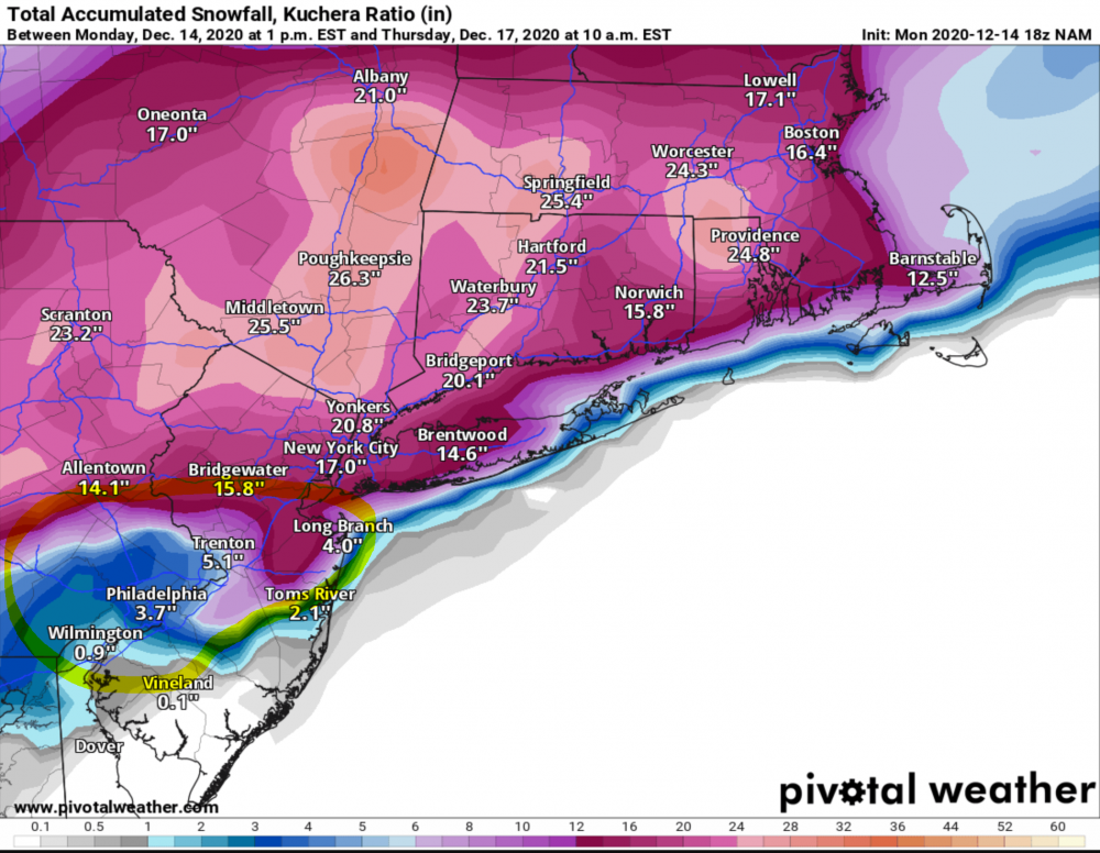
December 16-17, 2020 Winter Storm
Blizzard-on-GFS replied to Ralph Wiggum's topic in Philadelphia Region
Euro run is horrible. No one from I-95 east is getting more than slop with that track. Let’s hope the GFS holds serve. The Euro has been over amping some coastal storms in our area the last few years so we have hope. -
Yuck, horrible track for CNJ. I’m hoping the Euro is over amping this.
-
I'm from central NJ. (Southern Mercer County). There's gonna be a razer sharp cutoff around my parts. I think NYC and north is game set and match to get hammered regardless.
- 3,762 replies
-
- 1
-

-
- heavy snow
- heavy rain
- (and 3 more)
-
I meant to say ZR and Sleet. I'm real nervous for my area just NE of philly. NYC should be fine due to the latitude. I think the farther north you are the better with this storm.
-
Ugly as hell for I-95 and east, I have a feeling this is going to end up being a sleet fest for I-95. That warm nose is gonna muck things up for the coastal crew.
- 3,762 replies
-
- 2
-
-
- heavy snow
- heavy rain
- (and 3 more)
-
Aw man that’s perfect for I-95. This is my dream track, just a hair SE of the GFS.
- 3,762 replies
-
- 1
-
-
- heavy snow
- heavy rain
- (and 3 more)
-
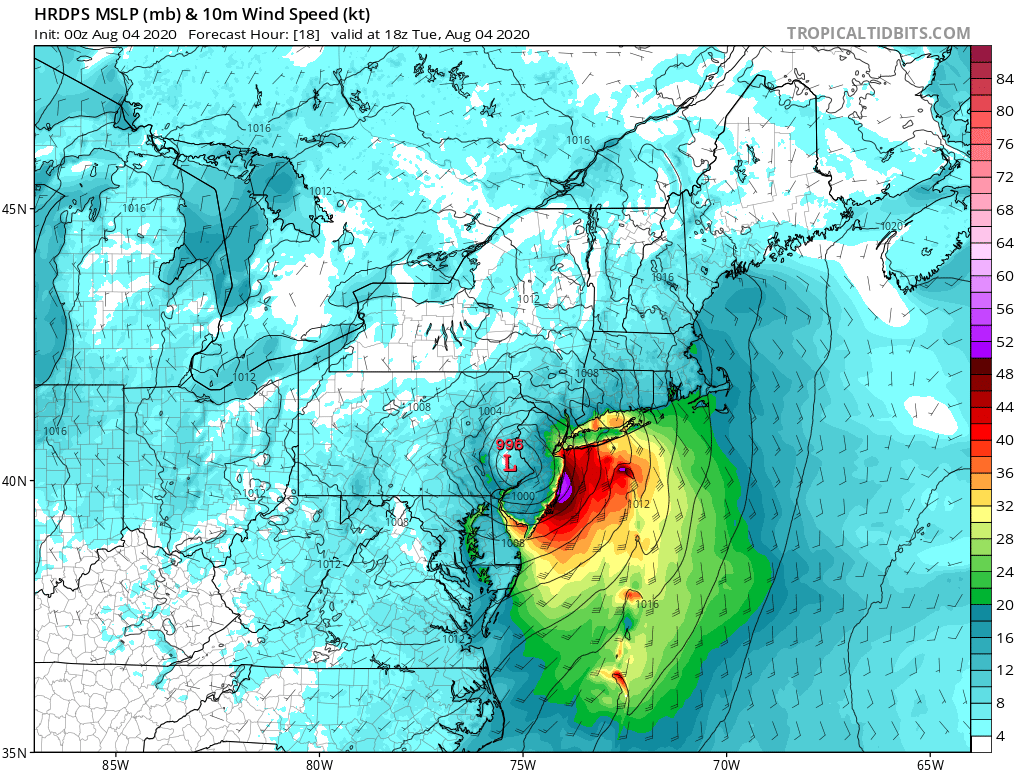
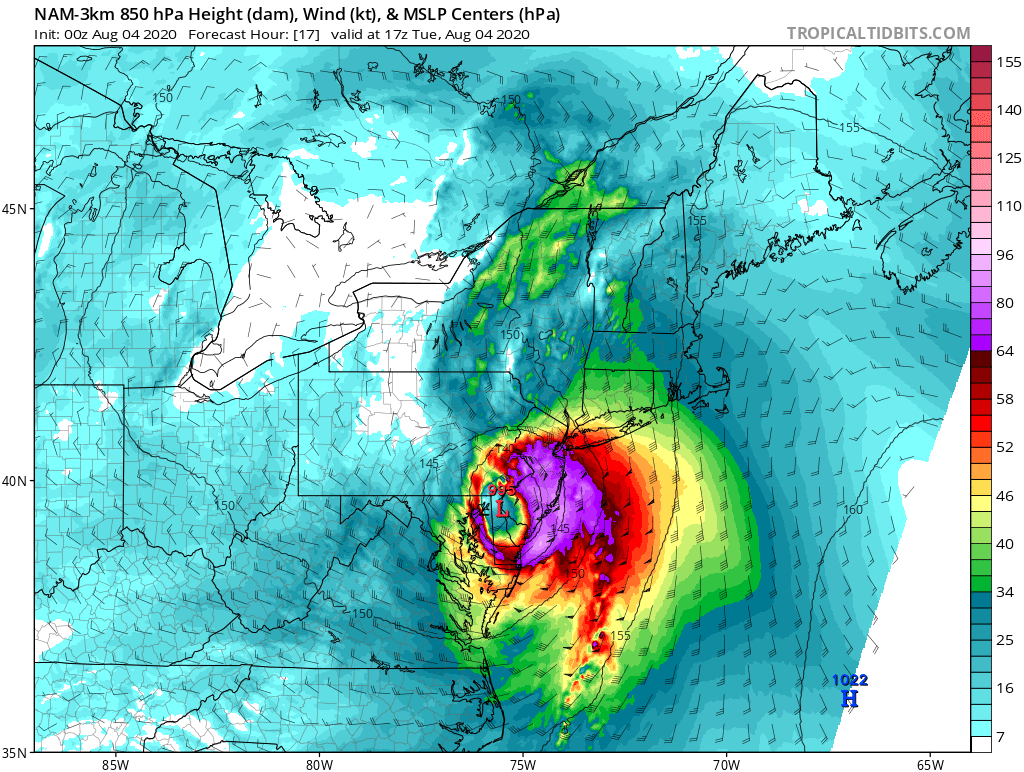
I am in Long Beach island and it appears instead of the worst of the winds are from the Cape May area on the due east side of the eyewall moving north East, can anyone confirm that with reports??
-
Yeah agree, I'm expecting a brief period of 50 mph. Some of the models have shown higher but they are most likely over done.
-
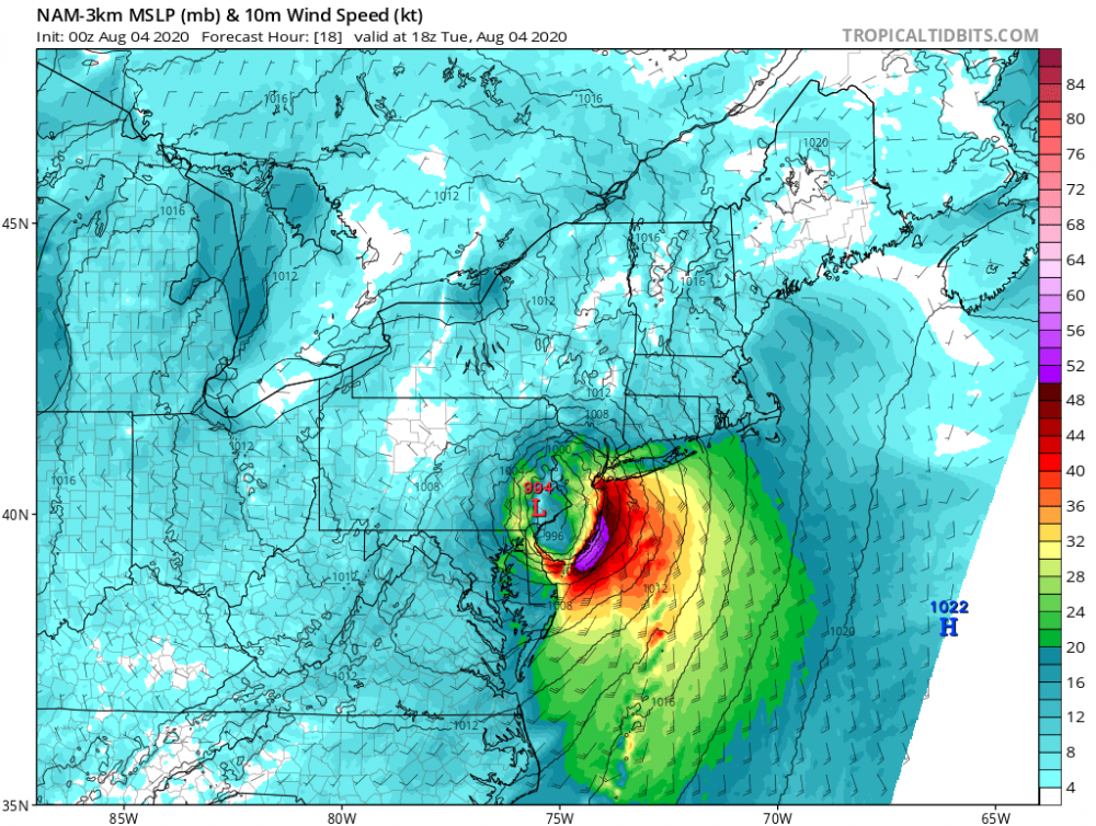
Nearly all of the MESO models show an intense band of roughly 60 MPH sustained winds making its way up the barrier islands of NJ. It's hard to believe but almost every model has it. Gusts would be even higher. I know it's crazy but these winds would probably warrant a hurricane warning for these areas; I doubt the warnings will be hoisted but it will be interesting to see how bad it gets.

-
Awesome, same. I'm in Ship Bottom, NJ on the bay side.
-
Not to be a downer but it's a shame this sub forum is dead. I'll be riding this storm out down LBI but there's not many people here to talk too. It's kind of annoying being a drifter between the Mid-Atlantic, NY, and New England sub-forums to find discussion. The true philly/jersey shore area posts get stuck here. Just my 2 cents, I get it if this post is deleted. Just please don't 5 post me.
-
These winds are going to be WICKED for the coast line. I don't care what anyone else says. This is a unique setup.

-
Wow! Yeah the Jersey Shore and Long Island are gonna get clocked with winds. I’m surprised people are downplaying it. Nearly all the models show hurricane force gusts for the shore points... Care to share the ukie wind map?
-
July 2020 General Discussions & Observations Thread
Blizzard-on-GFS replied to Rtd208's topic in New York City Metro
Here comes the eye!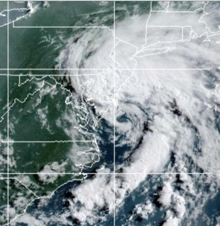
-
A tropical storm is likely gonna landfall in the area in the next 48 hours and there’s radio silence in this sub, where is everyone lol? People are sleeping on Fayz
-
Attention All Philly Subforum Members
Blizzard-on-GFS replied to Rjay's topic in Philadelphia Region
This subforum was great back in the day but it is now really beyond dead. I frequent the NYC forum much more even though my location doesn't quite align with the discussion.