wxsniss
-
Posts
5,780 -
Joined
-
Last visited
Content Type
Profiles
Blogs
Forums
American Weather
Media Demo
Store
Gallery
Everything posted by wxsniss
-
Just found you can actually see a mean SLR... begins 18:1 Sunday afternoon, drops to 13:1 overnight Monday across SNE... nothing too crazy In any case, I agree I don't see any guidance supporting widespread 20"+ amounts
-
Curious what goes into this blend... it keeps revving up. Here's the 1z Jan 23 NBM output:
-
I haven't had 6" in 4 years... I'd be thrilled with 12-18" On the other hand, ask every single member of this board wearing a lie detector test... the answer might be "when is any amount of snow enough?"
-
I think the isoentropic lift portion is slightly better (despite less cyclogen-CCB Monday) hence the relatively stable / slightly increased in CNE QPF in this run But the coastal portion of the storm... 0z last night has the best depiction of coastal portion I could find, mini CCB into Tuesday 6z... that portion of the storm I haven't seen recovered yet, but there are varying hints of it across the models. Need the energy to round trough and interact sooner
-
ICON has not recovered it's best look for Monday coastal development from 24 hours ago (0z Jan 22). Trough tilt was too progressive this run
-
ICON spread goods a tick more north in CNE 1.2+ most of SNE, 1.3-1.6 eastern areas Kuchera widespread 14-20
-
ICON!
-
Great stuff. Your posts read like a thriller that educates. What I'm looking for in next 72 hours to optimize that handoff from isoentropic to cyclogenic-CCB mechanisms: beyond just looking for an 850/925 low closing as far southwest as we can get it and maintaining easterly inflow lasting to 0z-6z Tuesday, I'm thinking earlier arrival of the energy rounding the trough and better tilt of the trough will help. At the moment, 0z ICON last night was the best depiction of getting this done I could find, with widespread 20"+ possible in eastern SNE. It's backed off a bit since but there are still hints on all guidance. Fwiw, 18z NAM at 6z Monday looks alot like 0z ICON... ie., potential to get very interesting Monday.
-
12z AIFS crushes and continues to hint at lingering coastal through Monday evening
-
An example of what I and others posted earlier... 0z ICON last night showed this as well (but backed off at 12z today). This is from 12z UK, keeps low level easterly flow into 0z-6z Tuesday... this is what we'd need to get us closer to 20": (EDIT: this is 850, 0z Tuesday, from 12z UK run Jan 22):
-
Without digging deeper for a better example, 0z ICON last night had the closest depiction of this we have a closed low 925-850 just southeast-east with easterly flow well into 0z-6z Tuesday Not totally outlandish either for these lower levels... Higher up 850-700 probably not happening fast enough
-
Agree, one of the more suspenseful remaining aspects of this imo if we're looking for the more "exotic" "nirvana" solutions of SWFE + CCB to get us to 20" and over I think ICON has had some of the better depictions of this, by virtue of faster infusion of energy and tilting of the trough
-
Agree Jerry I think 10-16" is a lock for most of SNE... but a few model runs flirting with better coastal development and capture... that would get us to 20" and more 13z Jan 22 NBM output...
-
Agree, exactly why in the cold vs. qpf debate about what's more important for a snowy winter, I always go with cold, even if it risks cold dry runs. The historic ones are often preceded by an anomalous cold dome... 2-14F, –2-27 Jan 21,22, 2005 3-19F Jan 6, 1996
-
12z ICON is great, but did back off a bit on the coastal development and capture... you can see at H5 the energy is slower to infuse and tilt the trough compared to the 0z ICON Just something to watch if we're looking for the more "exotic" "nirvana" solutions of SWFE on steroids + CCB to get us above 20"
-
NESIS 4-5 likely... these geographically massive ones you can see a mile away https://www.ncei.noaa.gov/access/monitoring/rsi/nesis
-
Very similar to 12z run at H5 and surface Doesn't quite develop and capture coastal like 0z ICON, but still would deliver 10-20" all of SNE assuming better than 10:1
-
Yeah EC AIFS followed same pattern as GFS... 0z and 12z similar, 18z outlier 0z and 12z better phase, coastal redevelopment, big hit SNE especially east
-
I like the comparisons, was lucky to experience both In terms of phase interactions, 0z GFS resembles 12z GFS as well as 0z ICON (ie., 18z GFS disconnect was hopefully an anomaly)
-
12z CMC and UK also had hints of more potent backend vorticity rounding the trough which would improve coastal development Just catching up... been a while since we've been staring at a region-wide foot+ with lots of buffer. Quick look, key variables determining 12"+ vs. 20"+ in SNE include • proficiency of coastal development, and how well it can vertically stack and better develop a comma head • ratios: 12-15:1? • CF enhancement for eastern areas? Thanks @MegaMike for that link earlier... here's an NBM product I haven't seen before, run 13z Jan 21:
-
January 2026 regional war/obs/disco thread
wxsniss replied to Baroclinic Zone's topic in New England
0z EPS jumped ~150 north compared to 12z EPS mean QPF now 0.7-1" all of SNE -
January 2026 regional war/obs/disco thread
wxsniss replied to Baroclinic Zone's topic in New England
Agree I've been browsing through NARR there are H5 similarities to Jan 1994 and Feb 2013... it's nice to be in a favorable setup for a change... in the what's-more-important cold vs. qpf debate for optimizing chances, we're rolling with cold for a few weeks and I think we do well -
January 2026 regional war/obs/disco thread
wxsniss replied to Baroclinic Zone's topic in New England
Quick glance and thoughts, sorry if posted earlier: • GFS / AIGFS alone in terms of timing of stream interactions, too little too late for SNE... can't be certain it's wrong, but I favor this having impact on SNE, and potentially very big impact if we can get northern stream interaction sooner rather than a later infusion of trailing energy at exit • some similarities to Feb 15-18 2003 aka PD2 at H5... https://www.meteo.psu.edu/ewall/NARR/2003/us0217.php • interesting that AI-GFS vs. AI-EC very different from each other compared to their strong consensus for Jan 18 event • lost in the trenches of forecasting an upcoming event... this definitely feels like we're turning a corner in SNE compared to last 4 years -
Rise of the Machines: January 18-19 Winter Storm Obs Thread
wxsniss replied to WxWatcher007's topic in New England
Appreciate it Vortex The flaws of KBOS/Logan snow reports (at some point near a water treatment area? jutting out into the ocean?) and poor representation of the downtown area such as Boston Commons are very familiar to this board lol In this specific case, my own measurement of 5.5” in Coolidge Corner area and neighboring PNS reports are validating… even with some margin of error, the city probably has not yet broken 6”: 1 S Brighton 5.5 in 1015 AM 01/19 Public Logan AP 5.3 in 1041 AM 01/19 Official NWS Obs Chelsea 5.2 in 1043 AM 01/19 Trained Spotter Boston 6.5 SW 5.1 in 0700 AM 01/19 COCORAHS West Roxbury 5.0 in 0940 AM 01/19 Trained Spotter Chelsea 4.9 in 0848 AM 01/19 Trained Spotter Boston 3.1 SW 4.7 in 0700 AM 01/19 COCORAHS Logan AP 4.6 in 0703 AM 01/19 Official NWS Obs Chelsea 4.5 in 0800 AM 01/19 Trained Spotter West Roxbury 4.3 in 0815 AM 01/19 Amateur Radio Logan AP 3.4 in 1200 AM 01/19 -
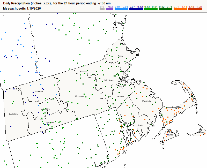
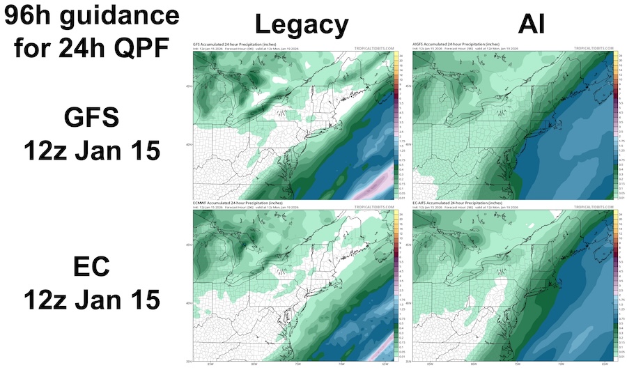
Quoted the above to help consolidate our tallies and impressions into the same thread for rolling reference... I agree: for Jan 18-19 2026 event, my impression was the AI models crushed legacy physics models in the 2-5 day range... we had multiple legacy models and cycles showing 0 QPF beyond far southeast MA vs. AI models showing with remarkable consistency solutions like those below. Within 24-48h, legacy models including EC/GFS and hi-res models NAM/HRRR etc were helpful to refine details. Can anyone suggest an objective and easily accessible measure of verification if not QPF? Here are CoCoRaHS QPF estimates for 7a-7a, compared to guidance below, all 24h ending 12z 1/19/2026: