
Jonathan
-
Posts
1,466 -
Joined
-
Last visited
Content Type
Profiles
Blogs
Forums
American Weather
Media Demo
Store
Gallery
Posts posted by Jonathan
-
-
23 minutes ago, burgertime said:
I can be one!
I second this nomination!
-
16 minutes ago, wncsnow said:
The GFS FV3 still gives us around a foot too. I think we are ok for 4-8 at least for now. Euro may say otherwise. The CMC and RGEM came north and the GFS did slightly too from its far south run
12z FV3?
-
47 minutes ago, superjames1992 said:
LOL, you guys always do this in SW VA, then after that lead minute NW jog end up getting 8-16" all snow while the areas south of the state line turn over to a raging sleet storm.

Meh, I get sleeted on too sometimes. If we lose the EURO this afternoon, it's officially worry time for real.
Currently hugging the 3k NAM/RGEM/CMC/ICON...that's perfectly reasonable, right?!
-
5 minutes ago, Disc said:
And RGEM and ICON.

Seriously though, are we still in this? I mean I'm further south than you but I still cant help but to feel it's slipping away. Guess for SWVA it's 3K NAM/ICON/RGEM vs 12K NAM and the globals?
-
48 minutes ago, Disc said:
I just got Oklahoma NAM'd. 12" to nada.
dat 3K NAM tho
-
I'm just really depressed this morning. Going to call out of work and drink.
-
 1
1
-
-
GFS ensemble is hundreds of miles south. Hundreds.
-
 3
3
-
 1
1
-
 1
1
-
-
8 minutes ago, BIG FROSTY said:
I’m not liking the shift south for us folks in NW NC and S Va. if the Euro shifts south imma gonna be very concerned! Until then I’ll hug the CMC

.Eh, I think we'll like the outcome of the FV3 actually. It has a very long duration event.
-
1
-
-
4 minutes ago, kvegas-wx said:
I was so trying to avoid this place. It feels kinda ookie in here. Like a bunch of people in VA had nightmares about suppression and collectively sweat the bed. I need a shower.....
We'll bathe in your NC tears come Monday.
 Enjoy your sleet.
 ")
-
47 minutes ago, Disc said:
I'm in full on weenie mode after seeing that NAM run.
Well that GFS run should drag you back to reality! Zero precip north of NC. Unreal.
-
Just now, WidreMann said:
It's not un-probably maybe going to be unable to definitely not unsnow.
I counted 5 negatives in there. I think 2 cancel each other out which leaves 1 negative, 1 undetermined and 1 positive. So everything's going according to plan. Except Brick's 6"+
1 minute ago, Disc said:Yes. Still very much in this. We are in a good spot and 6-12" is likely.
Good deal. Hopefully the precip doesn't underperform like the NAM's massive fail out in OK/TX. That was absolutely brutal. Also the 850 temps are crazy borderline. Bet I sleet down here closer to the NC border.
-
Man, with a winter storm impending you CAN'T miss a few hours on this board. It's great though. So much info.
I need a quick recap! @Buddy1987 @Disc we still in for this baby in SW VA?
-
9 minutes ago, GunBlade said:
I really really hope this storm is as great as many models show, but a word of caution, especially for those around 85 in NC. Enjoy the model runs but don’t live and die by them. Read the thread below and temper expectations. Better to be pleasantly surprised if the totals are close.
The pic and thread are from the Jan 17 storm that was a big bust. Not saying these storms are the same, just that the cutoff line and WAA are notoriously hard for models to get right. Union county was looking great the morning before the storm and we got shafted. QPF was also way overdone by the models
Its easy for most of us and myself to get wrapped up in these models but this is a tough area even for short range models to get right.
Hopefully this doesn’t repeat itself with this storm though!!

Reading back on that...good Lord...absolutely terrifying. I think EVERYONE needs to go back and read that.
-
2
-
-
Just now, wncsnow said:
Through 90 there is less total precip over WNC
Couple of models now showing that...hope that's not a trend
-
1
-
-
R.I.P. to the entire 18z GFS suite, old and new. But damn if the FV3 isn't lookin' like a snack!
-
1
-
-
Much lighter precip in W NC and S VA this time around.
-
Dew points are 4+ degrees colder in a lot of places on the NAM
-
1
-
2
-
-
Of course the Euro is beautiful, but we still had north trends on the before rock-solid FV3 and the wishy washy Canadian.
I don't like that all of a sudden we have this northern stream energy to throw a wrench in this deal. That's going to cause madness the next 48 hours.
-
1 minute ago, burgertime said:
Late end thump most of NC....if that happens it's just gonna snow itself out. Looks fantastic for you guys in CNC. CLT is also in on the action.
Jonathan, your stormvista maps are way ahead of WxBell, how's it look across the border around and west of Martinsville? I see sleet creeping to the border on WxBell maps.
-
Just now, burgertime said:
BOOM!
BURGER BOOM ENGAGE
-
2
-
-
1 minute ago, Jet Stream Rider said:
Does anyone have insight as to why the FV3 has had problems loading the last couple of days? Bothersome when its supposed to go operational any day now, right?
You'd think it'd be better as we approach January when it takes over.
I guess we wait til 5:00PM for frame hr102.
-
1
-
-
1 minute ago, ILMRoss said:
FV3 is fine, the low is going to gravitate towards the Huntsville/Knoxville area a little before the transfer because of the CAD forming lower pressures on the OTHER side of the Apps... One more thing to think about is the overall pressure field remains similar, but that little "L" icon is going to shift. It's there because Levi's or whoever's code puts that L at every local minimum... and in a transfer like this, that could be a lot of areas! Run to run, the "L" could jump by hundreds of miles, but in the grand scheme of things, it's probably not a big shift. It's a psychological thing!
Good point, sir. I am guilty of "quickly" rushing through surface output rather than MSLP anomalies, etc.
-
1
-
-
1 minute ago, Queencitywx said:
Like the euro PBP last night?

You can say what you want Jeremy but the EURO was much further north and 4-5 degrees warmer across the board. It was 3am and I was squinting at a cellphone. Totals cut, temps higher, more phasing. It was "OK" but it wasn't pretty or a continuation of our "southern slider" it'd previously been showing.
-
1
-
-
2 hours ago, burgertime said:
It could be worse. I've been here 3 years and the best snow we got stuck around for a whole half a day after it snowed....but we run into the same problems here. Mixing mixing mixing. Someone south of 40 on this storm is gonna get the screwing of a lifetime (and not a good one!) I'll bet.
I have a feeling that even I am gonna have mixing issues here across the border. ROA-DCA will end up jackpotting, you watch.

December 8-10, 2018 Winter Storm
in Southeastern States
Posted
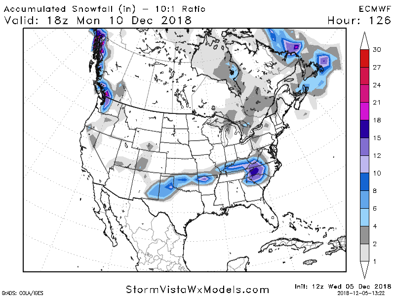
Euro was an absolute paste bomb for western NC all the way through SWVA.
Roanoke VA 12"
Martinsville 20"
Greensboro 17"
Hickory 20"
Wilkesboro 20"
Wake County 5-13" from SE to NW
Charlotte 7-10" from SE to NW