
Jonathan
-
Posts
1,466 -
Joined
-
Last visited
Content Type
Profiles
Blogs
Forums
American Weather
Media Demo
Store
Gallery
Posts posted by Jonathan
-
-
8 minutes ago, Blue_Ridge_Escarpment said:
03Z SREF really amped. Showing 4-6 in SW NC
Wow, yeah. SREF is juicy. Probably the most juiced run its had.
-
 1
1
-
-
Well the 6z GFS was one of the better runs we've had. Low closer to the coast, precip shield further west.
-
*crickets*
Turn the lights out and close down the thread, this one's over. Goodnight, Irene!
-
Comforting words will be needed ASAP.

-
2
-
-
2 minutes ago, BIG FROSTY said:
That's my hope, but it's early in the season. So they might catch this one and us next time!! I would like to see a storm where most on the board sees snow...... Hey I love my fellow weather junkies, But I'm really punching the walls hoping on that NW jog. lol

Same! We need a good old fashioned southern slider then a turn up the coast to give the Raleigh guys a shot too. I always root for everyone, but when it comes down to it, everyone wants it in their own backyard.

-
1
-
-
Just now, BIG FROSTY said:
I'm expecting to see a few flurries maybe a shower, why looking to my SE and seeing some real snow off in a distance!!! lol. Good luck down that way everybody!!!! Be sure and post some pics..............
I wouldn't rule out a tick more than token flakes for us, Frosty! Watch this thing jog NW tomorrow.
")
-
2
-
-
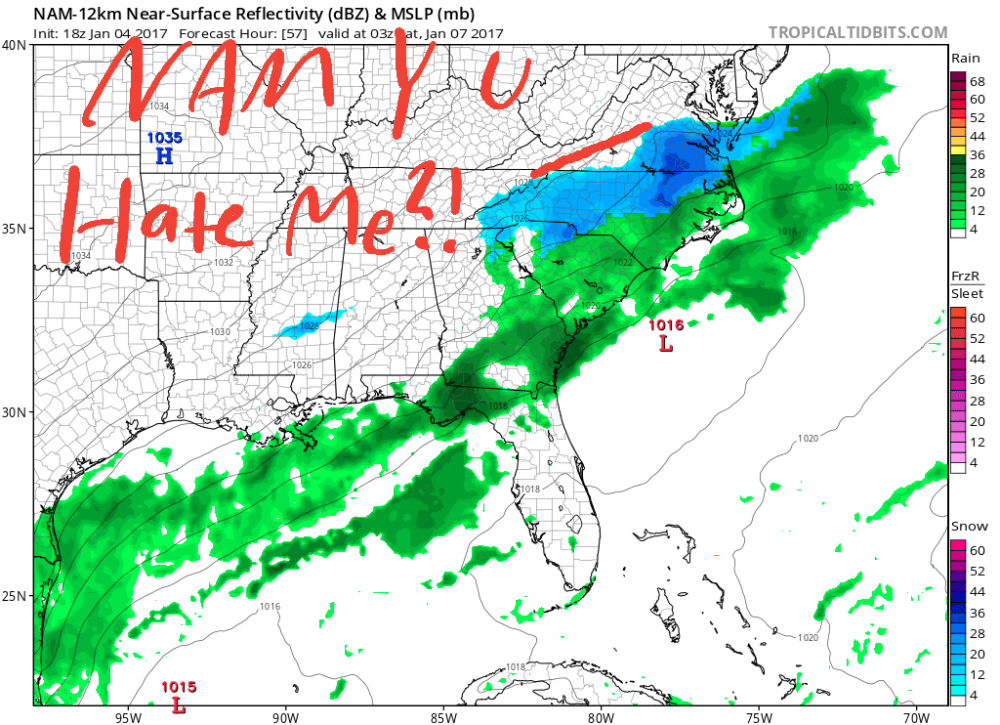
The precip shield on the models is still baffling me. Straight up razor blade cutoff with copious GOM moisture and some orographic lift east of the mtns. Does not compute lol.
-
Just now, CaryWx said:
Is that the mean Cheez?
Yes.
-
Why do the Pivotal maps look so different from TT maps? Precip is doubled on pivotal it looks like.
-
2 minutes ago, yoda said:
Meteocentre goes out to 144... but precipitation and h5 only goes out to 72
Gotcha, thanks yoda!
Anyway, to get back on topic, for those in western NC into southern VA (I-85 / I-77 corridors), do any models have a known sort of bias for not having enough precip on the western side of storm systems? Can't remember ever looking at a radar with a razor-edged cutoff on any side of a storm system. Even if precip is lighter (this isn't a huge system after all), I would think these areas would have a better shot at an all-snow event.
-
1
-
-
Think I'll stay up for the EURO to crush my dreams.
Where do you guys go to view the UKMET? The meteocentre site I have only goes out to 72 hours. Doesn't it go out to 120?
-
2
-
-
At this rate, we won't have a clue till Friday morning. I've seen plenty of flip flopping with models before, but this is the worst. And for such an insignificant system. Oy.
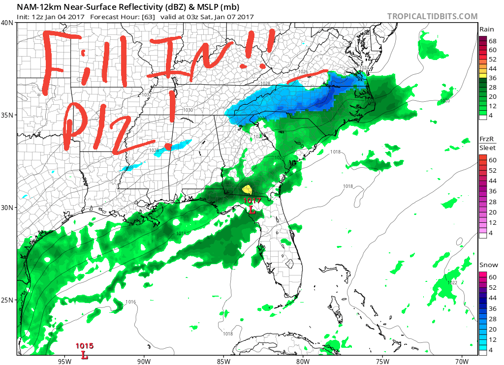
Something just doesn't look right with the NAM here. Two GL lows? The 500mb setup looks weird.
-
-
3 hours ago, franklin NCwx said:
Gfs will
It did
-
GFS BAYBEEEEE!!!!
-
What's with this precip gap in the NAM?
This is just cruel. Supernatural powers at hand here.

-
EURO, you have betrayed me.
Someone hold me.

-
Here's Webber's first call for those interested.
-
32 minutes ago, Cold Rain said:
Let me know if the hounds need any help!
Unfortunately, we're going to have to start to see some significant north shifts to get to storm mode.
You throwing out the EC/UK/CMC, CR? The GFS is the only model squashing this thing ATM.
-
2 minutes ago, buckeyefan1 said:
I have no idea

Figured it out. I had no idea your attachments got saved to your member profile. Now I have to go in and delete 127 attachments one by one with the board going up and down.
-
Never forget.
P.S. Why does the post attachment size change at random?
-
30 minutes ago, superjames1992 said:
This storm is making me miss Greensboro.
Hell, at this rate, GSO might miss out too.
-
"Taking a blend" is a cop out. Someone put out a REAL forecast.

-
2 minutes ago, mackerel_sky said:
Virginia too
VA BEEN up in here since 18z yesterday, fam!

The December to Remember 7th-8th blue turd winter threat thread.
in Southeastern States
Posted
Agreed, but question. Does the kuchera ratio not take those variables into its output?