
Jonathan
-
Posts
1,466 -
Joined
-
Last visited
Content Type
Profiles
Blogs
Forums
American Weather
Media Demo
Store
Gallery
Posts posted by Jonathan
-
-
1 minute ago, NorthHillsWx said:
Straight trash for sure
That's a shame. A local met around here said he used the FV3 for the December 2018 storm and it was almost spot-on with snow totals. He called it his "secret weapon" lol.
-
 2
2
-
-
How much credence do we lend to the FV3? Because that's about the snowiest, less sleety/icy modelk for southern VA into norther NC.
Isn't it a NAM upgrade?
-
1 minute ago, Disc said:
We're sitting good up here. I'm not ready to say 12" is a lock, but the trends this morning have been good.
You think we have a chance to hold on to sleet rather than freezing rain down towards Franklin and Patrick counties?
-
2 minutes ago, HKY_WX said:
The NAM is a realistic projection given the strength of the upper low. It's not truly a miller A if you look closely. There will be a surface/mid level Low over the northern deep south which throw those SE winds aloft (thus warming up mid-levels and causing sleet/zr). Still trying to see a way RDU doesn't changeover to rain but it's looking likely for a least a few hours given the strength of the coastal front. I do think it's possible we continue to see a trend SE due to the anomalous nature of the projection. It's not often you see Myrtle Beach get Zr and raleigh changeover to rain. Make me think there are some additional shifts to come.
So maybe no snow into VA? Talk about going from talks of 1-2 feet of snow to all sleet and ice that's wild.
-
Wow, what an absolute dumpster fire train wreck the Euro is...unreal. holy trucking buckets it's bad.
-
Of course we finally get the GFS to lay down now the Euro is gonna amp up.
-
5 minutes ago, BornAgain13 said:
It's not finished...
Actually, I...I think it is...what in the world lol cuts totals drastically.
-
GEFS 0z left 18z right
-
 2
2
-
-
EPS Control run is nuts. And this is just the weekend system.
-
 2
2
-
-
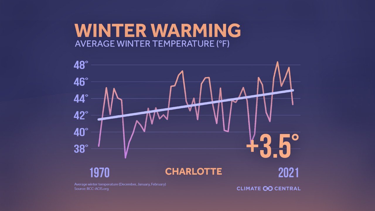
9 minutes ago, Jonathan said:
Can't believe we're still laughing at climate change in 2021, almost 2022.
This is an example of CLT from Brad P, it's the same no matter what city you look at.

-
4
-
-
6 hours ago, JoshM said:
Can't believe we're still laughing at climate change in 2021, almost 2022.
-
2
-
1
-
-
1 hour ago, CaryWx said:
Why do you say that?
Climate change.
-
If nothing else, I believe this winter will show us that the PNA is the most important teleconnection for anything even resembling wintertime in the east and especially the southeast.
We've scored many a time without a -NAO/AO because of just enough ridging out west. We can't "win" without a +PNA period.
-
4
-
-
The upcoming pattern really goes to show that south of New England (and especially south of the mid-Atlantic) you literally need EVERY. SINGLE. INDEX. to be in your favor to get cold or snow.
We have a MONSTER -NAO coming (ya know, the one they say is most important for SE wintry mischief), a MONSTER -EPO coming (ya know, the one they said would be the hardest to flip this winter), the MJO looking to move through phases 8-1-2 (ya know, the best cycle for SE wintry chances) but because of the ONE bad index, the -PNA, it all means squat to us for any shot of prolonged cold or even an outside shot at wintry precip.
What does it take to kill the SE ridge? Seems like climate change has made that feature permanent at this point.
-
1
-
-
13 hours ago, NorthHillsWx said:
There are some signs the western trough tries to propagate eastward and the raging pacific flow trends away with more west coast ridging towards the first week of January. SE ridge never goes away but at least our cutters will be going over the mountains instead of the UP of Michigan and cold air will be much closer instead of north of the Canadian border…
I believe the saying goes "close only counts in horseshoes and hand grenades." Even with a -EPO and a mega -NAO we still flop in the winter department with persistent west coast troughing. Insane but not unexpected. Better luck next year, fingers crossed for a Nino to return.
-
Isn't there a way to link your Tempest with your profile here on this site? I swear I thought I'd seen someone's in their signature or something before.
-
At least for southern VA, the precip is beginning to fill back in to the south and west. Several more hours of freezing drizzle look possible, which would accrue much faster than the heavy batch that came through this morning. The upper energy is still way out west. Plus we still have the evening batch of freezing rain. Don't think we're out of the woods at all yet.
-
Soundings still scream ZR though. Would really love a sleet storm but just don't see it happening.
-
1
-
 1
1
-
-
21 hours ago, Buddy1987 said:
I honestly hate even looking at any maps for this one. It's like getting punched in the gut while I'm still reeling from the left hook from Friday-Saturday. Lot of folks here still without power. We're in the bullseye yet again. Praying for more sleet or at least heavier rain so it'll be harder to accumulate.
Feels helpless basically KNOWING I'm gonna get clocked and there's nothing I can do about it. Can't even find any generators around here. Contemplated going to the OBX, as I'm off work Thursday thru Monday anyway.

-
Welp, it was nice knowing y'all!
-
1
-
-
Just now, Blue_Ridge_Escarpment said:
12Z UK looks really good at the end of the run for system 2.
Dang, already on to our next failure.
-
4
-
-
Well, that was fun while it lasted!

-
Well there's your 200+ mile north shift on the GFS.
Congrats Maryland!
-
1
-
-
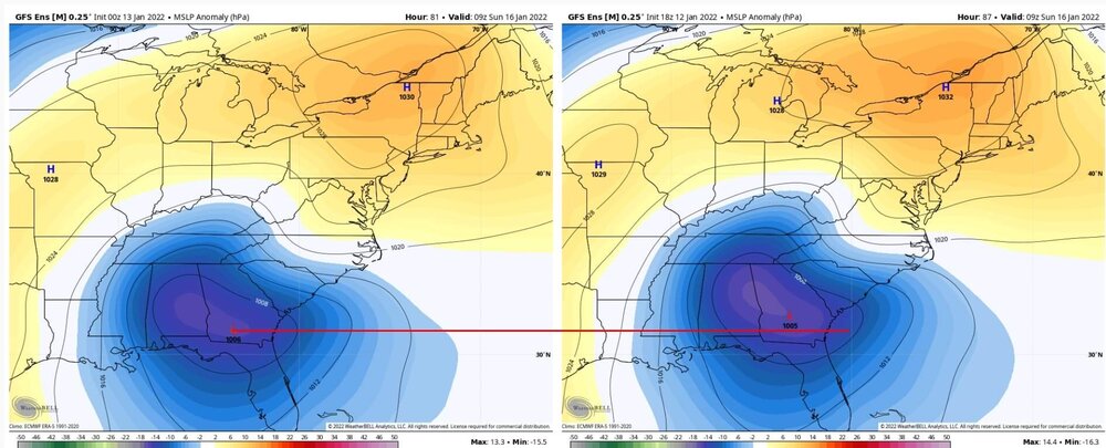
With the 0z/6z model suite, inside 36 hours, Virginia has been taken completely out of play. Absolutely unprecedented 100+ mile SOUTH shift on every single model. Congratulations GA, SC and NC. Unreal.

Jan 15-16 Winter Storm
in Southeastern States
Posted
Guess the old adage about the blind squirrel.
I am happy to see over the past 24 hours the trend for more sleet and less zr for the foothills. I never got my hands on a generator before last winter's ice storm and I doubt I could get one this weekend either.